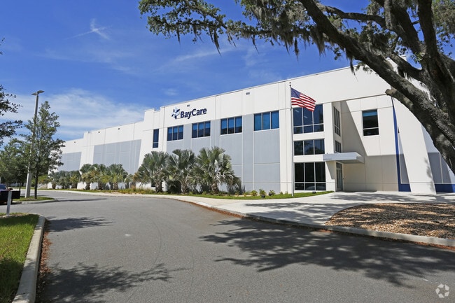
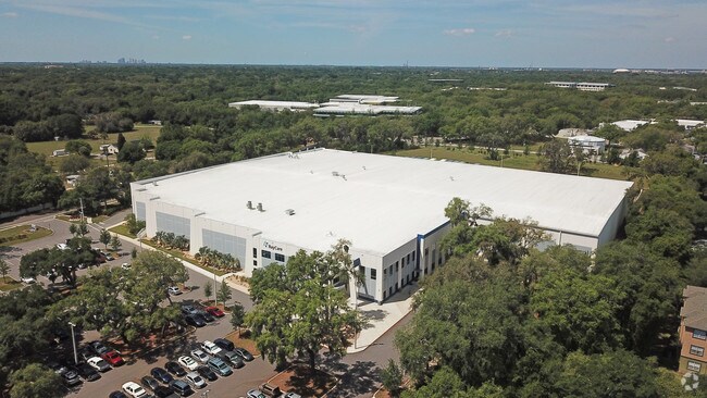
Property Record
7802 E Telecom Pky, Temple Terrace, FL 33637

Property Detail
7802 E Telecom Pky
T-12-28-19-5KQ-000000-0000B.0
TAMPA TELECOM PARK EASTERN 20 ACRES SUBDIVIS LOT B
Warehouse
Hillsborough
PROF
Florida
B and X Area of moderate flood hazard, usually the area between the limits of the 100-year and 500-year floods.
b
2024
18.08 AC
2025
NE Hillsborough/Univ
010810
Tampa/St Petersburg
170,172 SF
Tampa-St. Petersburg-Clearwater, FL
NEARBY LISTINGS FOR SALE OR LEASE
DEMOGRAPHICS near 7802 E Telecom Pky
1 mile
3 mile
5 mile
2025 Total Population
8,441
72,909
193,792
2030 Population
9,082
77,666
207,560
Pop Growth 2025-2030
+ 7.59%
+ 6.52%
+ 7.10%
Average Age
37
36
36
2025 Total Households
3,844
27,010
74,472
HH Growth 2025-2030
+ 7.80%
+ 7.06%
+ 7.33%
Median Household Inc
$67,546
$59,231
$52,972
Avg Household Size
2.10
2.30
2.40
2025 Avg HH Vehicles
1.00
2.00
2.00
Median Home Value
$367,611
$357,912
$341,625
Median Year Built
1993
1986
1986
Nearby Places
Map Layers
Map Styles
 Street
 Aerial
Layers
 Traffic
 Biking
Places
Listings with unknown addresses are not visible on the map
- Restaurants
- Banks
- Shops
- Fitness
- Groceries
PUBLIC TRANSPORTATION
AIRPORT
Tampa International
Drive
Walk
Distance
Tampa International
33 min
23.1 mi
St Pete-Clearwater International
Drive
Walk
Distance
St Pete-Clearwater International
51 min
32.4 mi
Freight Ports
Port of Tampa Bay
Drive
Walk
Distance
Port of Tampa Bay
26 min
16.6 mi
Nearby Properties
Address
Land Use
TOTAL SIZE
Lot Size
Zoning
Address
Land Use
TOTAL SIZE
Lot Size
Zoning
4,011,409 SF
1,558.97 AC
UC
Address
Land Use
TOTAL SIZE
Lot Size
Zoning
2,604,100 SF
83.27 AC
PD
Address
Land Use
TOTAL SIZE
Lot Size
Zoning
727,236 SF
61.10 AC
CU
Address
Land Use
TOTAL SIZE
Lot Size
Zoning
671,677 SF
72.27 AC
RMFA
Address
Land Use
TOTAL SIZE
Lot Size
Zoning
702,607 SF
63.42 AC
PROF
Address
Land Use
TOTAL SIZE
Lot Size
Zoning
598,043 SF
47.58 AC
PD
Address
Land Use
TOTAL SIZE
Lot Size
Zoning
594,270 SF
23.02 AC
PD
Address
Land Use
TOTAL SIZE
Lot Size
Zoning
319,292 SF
31.71 AC
PD
Address
Land Use
TOTAL SIZE
Lot Size
Zoning
344,877 SF
47.21 AC
PD
Address
Land Use
TOTAL SIZE
Lot Size
Zoning
306,031 SF
16.15 AC
PD-A
Address
Land Use
TOTAL SIZE
Lot Size
Zoning
351,811 SF
70.56 AC
CU
Address
Land Use
TOTAL SIZE
Lot Size
Zoning
287,530 SF
9.09 AC
PD
Address
Land Use
TOTAL SIZE
Lot Size
Zoning
374,282 SF
13.50 AC
PD
Address
Land Use
TOTAL SIZE
Lot Size
Zoning
706,512 SF
76.54 AC
PD
Address
Land Use
TOTAL SIZE
Lot Size
Zoning
285,330 SF
34.74 AC
RDC-12
Address
Land Use
TOTAL SIZE
Lot Size
Zoning
207,965 SF
20.94 AC
PD-A
Address
Land Use
TOTAL SIZE
Lot Size
Zoning
381,196 SF
10.69 AC
SPI-UC-1
Address
Land Use
TOTAL SIZE
Lot Size
Zoning
251,681 SF
4.33 AC
PD
Address
Land Use
TOTAL SIZE
Lot Size
Zoning
280,650 SF
11.92 AC
UMU-20
Address
Land Use
TOTAL SIZE
Lot Size
Zoning
365,401 SF
4.87 AC
SPI-UC-1
Address
Land Use
TOTAL SIZE
Lot Size
Zoning
163,045 SF
32.18 AC
PD
Address
Land Use
TOTAL SIZE
Lot Size
Zoning
193,509 SF
4.67 AC
DMU-35
Address
Land Use
TOTAL SIZE
Lot Size
Zoning
127,528 SF
11.45 AC
PD-A
Address
Land Use
TOTAL SIZE
Lot Size
Zoning
230,806 SF
20.72 AC
PD
Address
Land Use
TOTAL SIZE
Lot Size
Zoning
303,325 SF
17.01 AC
EI
Address
Land Use
TOTAL SIZE
Lot Size
Zoning
210,916 SF
16.22 AC
PROF
Address
Land Use
TOTAL SIZE
Lot Size
Zoning
377,800 SF
13.74 AC
IH
Address
Land Use
TOTAL SIZE
Lot Size
Zoning
155,769 SF
18.53 AC
CMU-12
Address
Land Use
TOTAL SIZE
Lot Size
Zoning
197,708 SF
9.81 AC
PD
The World's #1 Commercial Real Estate Marketplace
Connect with us
© 2026 CoStar Group
The information above has been obtained from sources believed reliable. While we do not doubt its accuracy we have not verified it and make no guarantee, warranty or representation about it. It is your responsibility to independently confirm its accuracy and completeness. Any projections, opinions, assumptions, or estimates used are for example only and do not represent the current or future performance of the property. The value of this transaction to you depends on tax and other factors which should be evaluated by your tax, financial, and legal advisors. You and your advisors should conduct a careful, independent investigation of the property to determine to your satisfaction the suitability of the property for your needs.