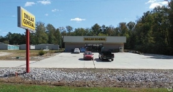
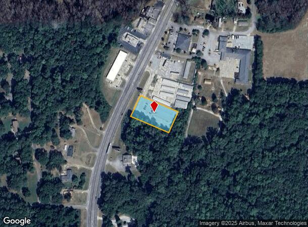
Property Record
7802 Highway 19 S, Zebulon, GA 30295
NEARBY LISTINGS FOR SALE OR LEASE
-
-
View all Zebulon listings for sale on LoopNet.com
Property Detail
7802 Highway 19 S
067B-066-C
City Of Zebulon Comm
Storebuilding
7802 U S HWY 19 TRACT 2
X
Pike
13171C0075C
Georgia
2024
0.98 AC
2024
Pike County
010102
Atlanta
9,100 SF
Atlanta-Sandy Springs-Roswell, GA
DEMOGRAPHICS near 7802 Highway 19 S
1 Mile
3 Mile
5 Mile
2024 Total Population
1,186
3,240
7,943
2029 Population
1,342
3,677
9,033
Pop Growth 2024-2029
+ 13.15%
+ 13.49%
+ 13.72%
Average Age
38
39
40
2024 Total Households
400
1,112
2,784
HH Growth 2024-2029
+ 12.75%
+ 13.04%
+ 13.22%
Median Household Inc
$62,426
$74,137
$82,663
Avg Household Size
2.80
2.80
2.80
2024 Avg HH Vehicles
2.00
2.00
3.00
Median Home Value
$240,594
$250,704
$259,655
Median Year Built
1986
1991
1994
Nearby Places
- Restaurants
- Banks
- Shops
- Fitness
- Groceries
SALE & LEASE HISTORY
LISTING DATE
SALE/LEASE

Jan 30, 2018
For Sale
Nearby Properties
Address
Land Use
TOTAL SIZE
Lot Size
Zoning
Address
Land Use
TOTAL SIZE
Lot Size
Zoning
94.92 AC
RESIDENTIA
Address
Land Use
TOTAL SIZE
Lot Size
Zoning
61,210 SF
11.21 AC
RESIDENTIA
Address
Land Use
TOTAL SIZE
Lot Size
Zoning
57.92 AC
RESIDENTIA
Address
Land Use
TOTAL SIZE
Lot Size
Zoning
43 AC
RESIDENTIA
Address
Land Use
TOTAL SIZE
Lot Size
Zoning
31.29 AC
RESIDENTIA
Address
Land Use
TOTAL SIZE
Lot Size
Zoning
22,626 SF
22.06 AC
RESIDENTIA
Address
Land Use
TOTAL SIZE
Lot Size
Zoning
16,625 SF
22.01 AC
Address
Land Use
TOTAL SIZE
Lot Size
Zoning
8,468 SF
42.01 AC
RESIDENTIA
Address
Land Use
TOTAL SIZE
Lot Size
Zoning
27,275 SF
10 AC
RESIDENTIA
Address
Land Use
TOTAL SIZE
Lot Size
Zoning
18,425 SF
1.21 AC
RESIDENTIA
Address
Land Use
TOTAL SIZE
Lot Size
Zoning
5,192 SF
4.97 AC
RESIDENTIA
Address
Land Use
TOTAL SIZE
Lot Size
Zoning
19,390 SF
3.49 AC
RESIDENTIA
Address
Land Use
TOTAL SIZE
Lot Size
Zoning
89,460 SF
17.50 AC
RESIDENTIA
Address
Land Use
TOTAL SIZE
Lot Size
Zoning
27,500 SF
9.65 AC
Address
Land Use
TOTAL SIZE
Lot Size
Zoning
23,608 SF
21.82 AC
RESIDENTIA
Address
Land Use
TOTAL SIZE
Lot Size
Zoning
5,000 SF
212.48 AC
RESIDENTIA
Address
Land Use
TOTAL SIZE
Lot Size
Zoning
24.58 AC
RESIDENTIA
Address
Land Use
TOTAL SIZE
Lot Size
Zoning
3,200 SF
200 AC
RESIDENTIA
Address
Land Use
TOTAL SIZE
Lot Size
Zoning
13,731 SF
2.50 AC
RESIDENTIA
Address
Land Use
TOTAL SIZE
Lot Size
Zoning
238.60 AC
Address
Land Use
TOTAL SIZE
Lot Size
Zoning
5,824 SF
1.47 AC
RESIDENTIA
Address
Land Use
TOTAL SIZE
Lot Size
Zoning
6,300 SF
2.29 AC
Address
Land Use
TOTAL SIZE
Lot Size
Zoning
7,369 SF
1.68 AC
RESIDENTIA
Address
Land Use
TOTAL SIZE
Lot Size
Zoning
213.54 AC
RESIDENTIA
Address
Land Use
TOTAL SIZE
Lot Size
Zoning
9,062 SF
2.11 AC
RESIDENTIA
Address
Land Use
TOTAL SIZE
Lot Size
Zoning
9,000 SF
2.36 AC
RESIDENTIA
Address
Land Use
TOTAL SIZE
Lot Size
Zoning
25,200 SF
4.50 AC
Address
Land Use
TOTAL SIZE
Lot Size
Zoning
256.49 AC
Address
Land Use
TOTAL SIZE
Lot Size
Zoning
202.60 AC
RESIDENTIA
Address
Land Use
TOTAL SIZE
Lot Size
Zoning
10,014 SF
3.27 AC
COMMERCIAL
The World's #1 Commercial Real Estate Marketplace
Connect with us
© 2025 CoStar Group
The information above has been obtained from sources believed reliable. While we do not doubt its accuracy we have not verified it and make no guarantee, warranty or representation about it. It is your responsibility to independently confirm its accuracy and completeness. Any projections, opinions, assumptions, or estimates used are for example only and do not represent the current or future performance of the property. The value of this transaction to you depends on tax and other factors which should be evaluated by your tax, financial, and legal advisors. You and your advisors should conduct a careful, independent investigation of the property to determine to your satisfaction the suitability of the property for your needs.