Property Record
7807 Baymeadows Rd E, Jacksonville, FL 32256

Property Detail
7807 Baymeadows Rd E
167745-3338
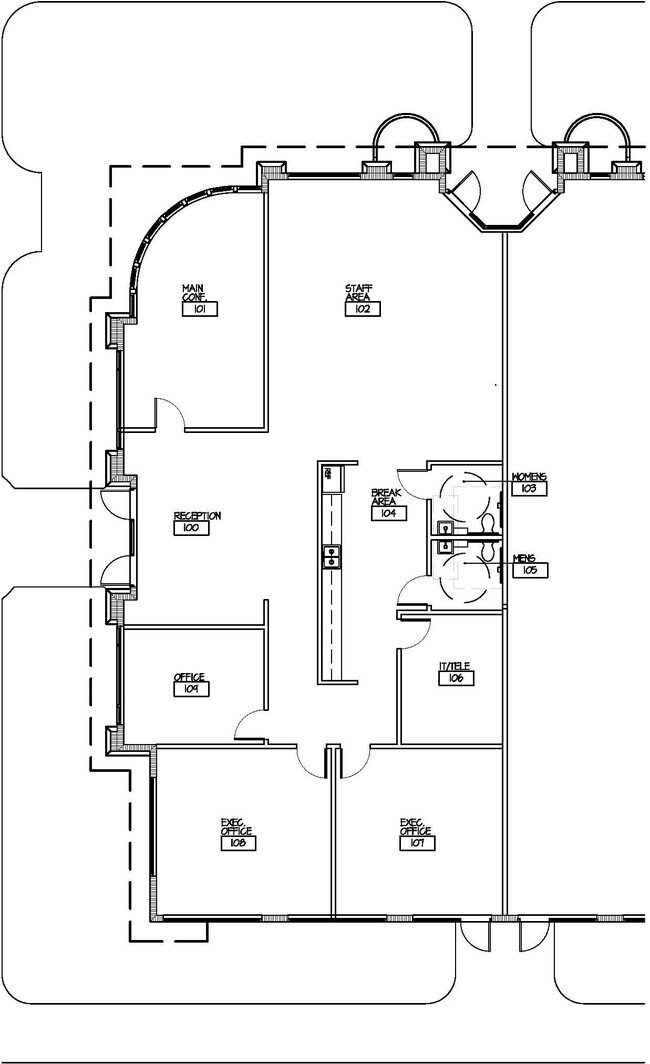
20-3S-28E HAMPTON PROFESSIONAL PARK OFFICE CONDOMINIUM UNIT 401 BLDG 4 6.66% INT COMMON ELEMENTS O/R 12869-684
Officecondo
Duval
PUD
Florida
C and X Area of minimal flood hazard, usually depicted on FIRMs as above the 500-year flood level.
0.06 AC
2025
Butler/Baymeadows
2026
Jacksonville (Florida)
014424
Jacksonville, FL
3,649 SF
NEARBY LISTINGS FOR SALE OR LEASE
DEMOGRAPHICS near 7807 Baymeadows Rd E
1 mile
3 mile
5 mile
2025 Total Population
7,195
48,918
138,948
2030 Population
7,710
52,260
148,107
Pop Growth 2025-2030
+ 7.16%
+ 6.83%
+ 6.59%
Average Age
40
38
38
2025 Total Households
3,592
21,963
60,921
HH Growth 2025-2030
+ 7.38%
+ 6.97%
+ 6.85%
Median Household Inc
$83,293
$83,999
$79,699
Avg Household Size
2.00
2.10
2.20
2025 Avg HH Vehicles
2.00
2.00
2.00
Median Home Value
$431,881
$420,848
$407,948
Median Year Built
2009
2003
2000
Nearby Places
Map Layers
Map Styles
 Street
 Aerial
Layers
 Traffic
 Biking
Places
Listings with unknown addresses are not visible on the map
- Restaurants
- Banks
- Shops
- Fitness
- Groceries
PUBLIC TRANSPORTATION
AIRPORT
Jacksonville International
Drive
Walk
Distance
Jacksonville International
34 min
24.5 mi
Freight Ports
Jacksonville Port
Drive
Walk
Distance
Jacksonville Port
25 min
16.1 mi
SALE & LEASE HISTORY
LISTING DATE
SALE/LEASE

May 12, 2025
For Sale
Jun 12, 2018
For Lease
Apr 30, 2021
For Lease
Nearby Properties
Address
Land Use
TOTAL SIZE
Lot Size
Zoning
Address
Land Use
TOTAL SIZE
Lot Size
Zoning
387,908 SF
32.59 AC
PUD
Address
Land Use
TOTAL SIZE
Lot Size
Zoning
297,275 SF
38.30 AC
PUD
Address
Land Use
TOTAL SIZE
Lot Size
Zoning
1,037,304 SF
103.91 AC
PUD
Address
Land Use
TOTAL SIZE
Lot Size
Zoning
1,013,318 SF
131.30 AC
PUD
Address
Land Use
TOTAL SIZE
Lot Size
Zoning
449,658 SF
8.78 AC
PUD
Address
Land Use
TOTAL SIZE
Lot Size
Zoning
371,068 SF
19.22 AC
PUD
Address
Land Use
TOTAL SIZE
Lot Size
Zoning
283,724 SF
28.50 AC
PUD
Address
Land Use
TOTAL SIZE
Lot Size
Zoning
444,532 SF
27.22 AC
PUD
Address
Land Use
TOTAL SIZE
Lot Size
Zoning
186,482 SF
33.57 AC
PUD
Address
Land Use
TOTAL SIZE
Lot Size
Zoning
223,939 SF
13.28 AC
PUD
Address
Land Use
TOTAL SIZE
Lot Size
Zoning
242,868 SF
13.45 AC
PUD
Address
Land Use
TOTAL SIZE
Lot Size
Zoning
345,841 SF
15.16 AC
PUD
Address
Land Use
TOTAL SIZE
Lot Size
Zoning
216,370 SF
10.02 AC
PUD
Address
Land Use
TOTAL SIZE
Lot Size
Zoning
279,038 SF
28.39 AC
PUD
Address
Land Use
TOTAL SIZE
Lot Size
Zoning
954,167 SF
56.79 AC
PUD
Address
Land Use
TOTAL SIZE
Lot Size
Zoning
262,453 SF
17.09 AC
PUD
Address
Land Use
TOTAL SIZE
Lot Size
Zoning
475,463 SF
37.20 AC
PUD
Address
Land Use
TOTAL SIZE
Lot Size
Zoning
255,951 SF
5.58 AC
PUD
Address
Land Use
TOTAL SIZE
Lot Size
Zoning
306,416 SF
12.27 AC
PUD
Address
Land Use
TOTAL SIZE
Lot Size
Zoning
371,698 SF
12.86 AC
PUD
Address
Land Use
TOTAL SIZE
Lot Size
Zoning
258,174 SF
10.55 AC
PUD
Address
Land Use
TOTAL SIZE
Lot Size
Zoning
383,228 SF
40.69 AC
PUD
Address
Land Use
TOTAL SIZE
Lot Size
Zoning
276,424 SF
5.06 AC
PUD
Address
Land Use
TOTAL SIZE
Lot Size
Zoning
171,972 SF
9 AC
PUD
Address
Land Use
TOTAL SIZE
Lot Size
Zoning
288,252 SF
4.60 AC
PUD
Address
Land Use
TOTAL SIZE
Lot Size
Zoning
464,189 SF
44.85 AC
RMD-D
Address
Land Use
TOTAL SIZE
Lot Size
Zoning
282,233 SF
13.70 AC
PUD
Address
Land Use
TOTAL SIZE
Lot Size
Zoning
296,145 SF
23.22 AC
PUD
Address
Land Use
TOTAL SIZE
Lot Size
Zoning
322,363 SF
14.96 AC
PUD
Address
Land Use
TOTAL SIZE
Lot Size
Zoning
249,222 SF
42.67 AC
PUD
The World's #1 Commercial Real Estate Marketplace
Connect with us
© 2026 CoStar Group
The information above has been obtained from sources believed reliable. While we do not doubt its accuracy we have not verified it and make no guarantee, warranty or representation about it. It is your responsibility to independently confirm its accuracy and completeness. Any projections, opinions, assumptions, or estimates used are for example only and do not represent the current or future performance of the property. The value of this transaction to you depends on tax and other factors which should be evaluated by your tax, financial, and legal advisors. You and your advisors should conduct a careful, independent investigation of the property to determine to your satisfaction the suitability of the property for your needs.