Property Record
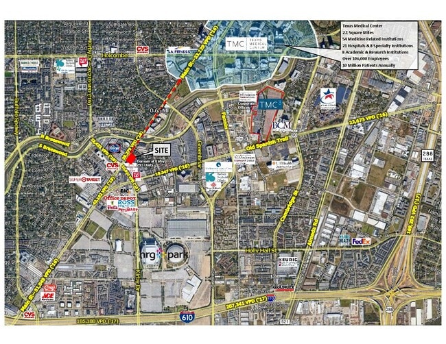
7807 Main St, Houston, TX 77030


Property Detail
7807 Main St
0440920000940
TR 7H-1A ABST 645 P W ROSE
Warehouse
HARRIS
AE The base floodplain where base flood elevations are provided. AE Zones are now used on new format FIRMs instead of A1-A30 Zones.
Texas
2024
1.36 AC
2025
Inner Loop University
412201
Houston
47,918 SF
Houston-Pasadena-The Woodlands, TX
NEARBY LISTINGS FOR SALE OR LEASE
DEMOGRAPHICS near 7807 Main St
1 mile
3 mile
5 mile
2025 Total Population
24,782
169,567
509,653
2030 Population
26,815
182,787
549,966
Pop Growth 2025-2030
+ 8.20%
+ 7.80%
+ 7.91%
Average Age
36
38
38
2025 Total Households
13,295
79,231
228,864
HH Growth 2025-2030
+ 8.34%
+ 8.17%
+ 8.38%
Median Household Inc
$68,634
$82,869
$77,588
Avg Household Size
1.80
2.00
2.10
2025 Avg HH Vehicles
1.00
1.00
1.00
Median Home Value
$401,923
$676,678
$469,318
Median Year Built
1991
1993
1991
Nearby Places
Map Layers
Map Styles
 Street
 Aerial
Layers
 Traffic
 Biking
Places
Listings with unknown addresses are not visible on the map
- Restaurants
- Banks
- Shops
- Fitness
- Groceries
PUBLIC TRANSPORTATION
TRANSIT/SUBWAY
Smith Lands (Redline - Harris County Metropolitan Transit Authority METRO Rail (METRORail))
Drive
Walk
Distance
Smith Lands (Redline - Harris County Metropolitan Transit Authority METRO Rail (METRORail))
2 min
14 min
0.7 mi
AIRPORT
William P Hobby
Drive
Walk
Distance
William P Hobby
26 min
13.4 mi
George Bush Intcntl/Houston
Drive
Walk
Distance
George Bush Intcntl/Houston
35 min
24.4 mi
SALE & LEASE HISTORY
LISTING DATE
SALE/LEASE

Oct 12, 2021
For Lease
Jun 12, 2019
For Lease
Jul 23, 2019
For Lease
Jan 22, 2021
For Lease
Nearby Properties
Address
Land Use
TOTAL SIZE
Lot Size
Zoning
Address
Land Use
TOTAL SIZE
Lot Size
Zoning
519,409 SF
1.52 AC
Address
Land Use
TOTAL SIZE
Lot Size
Zoning
1,252,274 SF
2.02 AC
Address
Land Use
TOTAL SIZE
Lot Size
Zoning
1,880,742 SF
20.77 AC
Address
Land Use
TOTAL SIZE
Lot Size
Zoning
704,249 SF
2.34 AC
Address
Land Use
TOTAL SIZE
Lot Size
Zoning
1,044,305 SF
3.16 AC
Address
Land Use
TOTAL SIZE
Lot Size
Zoning
1,359,194 SF
Address
Land Use
TOTAL SIZE
Lot Size
Zoning
402,467 SF
28.30 AC
Address
Land Use
TOTAL SIZE
Lot Size
Zoning
1,009,859 SF
28.73 AC
Address
Land Use
TOTAL SIZE
Lot Size
Zoning
464,134 SF
3.57 AC
Address
Land Use
TOTAL SIZE
Lot Size
Zoning
701,043 SF
4.69 AC
Address
Land Use
TOTAL SIZE
Lot Size
Zoning
958,147 SF
16.60 AC
Address
Land Use
TOTAL SIZE
Lot Size
Zoning
507,499 SF
7.66 AC
Address
Land Use
TOTAL SIZE
Lot Size
Zoning
310,967 SF
1.38 AC
Address
Land Use
TOTAL SIZE
Lot Size
Zoning
444,589 SF
11 AC
Address
Land Use
TOTAL SIZE
Lot Size
Zoning
577,327 SF
28.80 AC
Address
Land Use
TOTAL SIZE
Lot Size
Zoning
828,746 SF
7.76 AC
Address
Land Use
TOTAL SIZE
Lot Size
Zoning
396,888 SF
2.02 AC
Address
Land Use
TOTAL SIZE
Lot Size
Zoning
840,388 SF
0.91 AC
Address
Land Use
TOTAL SIZE
Lot Size
Zoning
1,279,489 SF
2.83 AC
Address
Land Use
TOTAL SIZE
Lot Size
Zoning
1,098,342 SF
8.81 AC
Address
Land Use
TOTAL SIZE
Lot Size
Zoning
261,388 SF
1.56 AC
Address
Land Use
TOTAL SIZE
Lot Size
Zoning
171,997 SF
1.15 AC
Address
Land Use
TOTAL SIZE
Lot Size
Zoning
486,076 SF
3.79 AC
Address
Land Use
TOTAL SIZE
Lot Size
Zoning
565,246 SF
1.14 AC
Address
Land Use
TOTAL SIZE
Lot Size
Zoning
552,795 SF
4.29 AC
Address
Land Use
TOTAL SIZE
Lot Size
Zoning
320,710 SF
1.19 AC
Address
Land Use
TOTAL SIZE
Lot Size
Zoning
517,548 SF
1.60 AC
Address
Land Use
TOTAL SIZE
Lot Size
Zoning
519,237 SF
1.73 AC
Address
Land Use
TOTAL SIZE
Lot Size
Zoning
316,101 SF
2.12 AC
Address
Land Use
TOTAL SIZE
Lot Size
Zoning
527,457 SF
6.21 AC
The World's #1 Commercial Real Estate Marketplace
Connect with us
© 2026 CoStar Group
The information above has been obtained from sources believed reliable. While we do not doubt its accuracy we have not verified it and make no guarantee, warranty or representation about it. It is your responsibility to independently confirm its accuracy and completeness. Any projections, opinions, assumptions, or estimates used are for example only and do not represent the current or future performance of the property. The value of this transaction to you depends on tax and other factors which should be evaluated by your tax, financial, and legal advisors. You and your advisors should conduct a careful, independent investigation of the property to determine to your satisfaction the suitability of the property for your needs.