Property Record
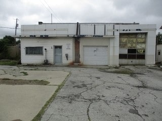
781 Davids St, Marion, OH 43302

Property Detail
781 Davids St
Marion, OH
OAKGROVE LOTS 10147-8 PG 29
12-3290003.500
Marion
Autorepair
Ohio
B and X Area of moderate flood hazard, usually the area between the limits of the 100-year and 500-year floods.
10147
2024
0.17 AC
2025
Ohio North Area
000400
Other Market Areas
1,452 SF
NEARBY LISTINGS FOR SALE OR LEASE
DEMOGRAPHICS near 781 Davids St
1 mile
3 mile
5 mile
2025 Total Population
10,900
36,256
47,125
2030 Population
10,958
36,424
47,190
Pop Growth 2025-2030
+ 0.53%
+ 0.46%
+ 0.14%
Average Age
39
40
41
2025 Total Households
4,460
15,186
18,696
HH Growth 2025-2030
+ 0.56%
+ 0.43%
+ 0.13%
Median Household Inc
$50,256
$47,875
$51,534
Avg Household Size
2.30
2.30
2.30
2025 Avg HH Vehicles
2.00
2.00
2.00
Median Home Value
$89,450
$125,560
$142,722
Median Year Built
1949
1955
1960
Nearby Places
Map Layers
Map Styles
 Street
 Aerial
Layers
 Traffic
 Biking
Places
Listings with unknown addresses are not visible on the map
- Restaurants
- Banks
- Shops
- Fitness
- Groceries
SALE & LEASE HISTORY
LISTING DATE
SALE/LEASE

Oct 08, 2018
For Sale
Nearby Properties
Address
Land Use
TOTAL SIZE
Lot Size
Zoning
Address
Land Use
TOTAL SIZE
Lot Size
Zoning
304,391 SF
19.05 AC
Address
Land Use
TOTAL SIZE
Lot Size
Zoning
135,911 SF
19.60 AC
Address
Land Use
TOTAL SIZE
Lot Size
Zoning
232,864 SF
38.03 AC
Address
Land Use
TOTAL SIZE
Lot Size
Zoning
264,578 SF
40.74 AC
Address
Land Use
TOTAL SIZE
Lot Size
Zoning
340,408 SF
47.81 AC
Address
Land Use
TOTAL SIZE
Lot Size
Zoning
67,783 SF
21.85 AC
Address
Land Use
TOTAL SIZE
Lot Size
Zoning
93,835 SF
14.41 AC
Address
Land Use
TOTAL SIZE
Lot Size
Zoning
60,165 SF
Address
Land Use
TOTAL SIZE
Lot Size
Zoning
68,111 SF
14.24 AC
Address
Land Use
TOTAL SIZE
Lot Size
Zoning
61,664 SF
10.86 AC
Address
Land Use
TOTAL SIZE
Lot Size
Zoning
63,161 SF
10.02 AC
Address
Land Use
TOTAL SIZE
Lot Size
Zoning
588,222 SF
27.92 AC
Address
Land Use
TOTAL SIZE
Lot Size
Zoning
263,963 SF
40.86 AC
Address
Land Use
TOTAL SIZE
Lot Size
Zoning
23,386 SF
78.15 AC
Address
Land Use
TOTAL SIZE
Lot Size
Zoning
645,632 SF
45.90 AC
Address
Land Use
TOTAL SIZE
Lot Size
Zoning
51,030 SF
4.19 AC
Address
Land Use
TOTAL SIZE
Lot Size
Zoning
140,834 SF
16.63 AC
Address
Land Use
TOTAL SIZE
Lot Size
Zoning
32,260 SF
7.73 AC
Address
Land Use
TOTAL SIZE
Lot Size
Zoning
58,756 SF
0.15 AC
Address
Land Use
TOTAL SIZE
Lot Size
Zoning
37,566 SF
Address
Land Use
TOTAL SIZE
Lot Size
Zoning
57,802 SF
5.66 AC
Address
Land Use
TOTAL SIZE
Lot Size
Zoning
265,232 SF
17.45 AC
Address
Land Use
TOTAL SIZE
Lot Size
Zoning
45,588 SF
5.23 AC
Address
Land Use
TOTAL SIZE
Lot Size
Zoning
147,097 SF
12.07 AC
Address
Land Use
TOTAL SIZE
Lot Size
Zoning
32,124 SF
2.05 AC
Address
Land Use
TOTAL SIZE
Lot Size
Zoning
60,130 SF
7.41 AC
Address
Land Use
TOTAL SIZE
Lot Size
Zoning
116,215 SF
13.32 AC
Address
Land Use
TOTAL SIZE
Lot Size
Zoning
38,142 SF
40.27 AC
Address
Land Use
TOTAL SIZE
Lot Size
Zoning
433,652 SF
8.10 AC
Address
Land Use
TOTAL SIZE
Lot Size
Zoning
75,324 SF
8.57 AC
The World's #1 Commercial Real Estate Marketplace
Connect with us
© 2026 CoStar Group
The information above has been obtained from sources believed reliable. While we do not doubt its accuracy we have not verified it and make no guarantee, warranty or representation about it. It is your responsibility to independently confirm its accuracy and completeness. Any projections, opinions, assumptions, or estimates used are for example only and do not represent the current or future performance of the property. The value of this transaction to you depends on tax and other factors which should be evaluated by your tax, financial, and legal advisors. You and your advisors should conduct a careful, independent investigation of the property to determine to your satisfaction the suitability of the property for your needs.