Property Record
781 Lodge Rd, Ardmore, OK 73401

NEARBY LISTINGS FOR SALE OR LEASE
-
-
View all Ardmore listings for sale on LoopNet.com
Property Detail
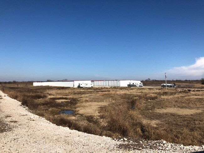
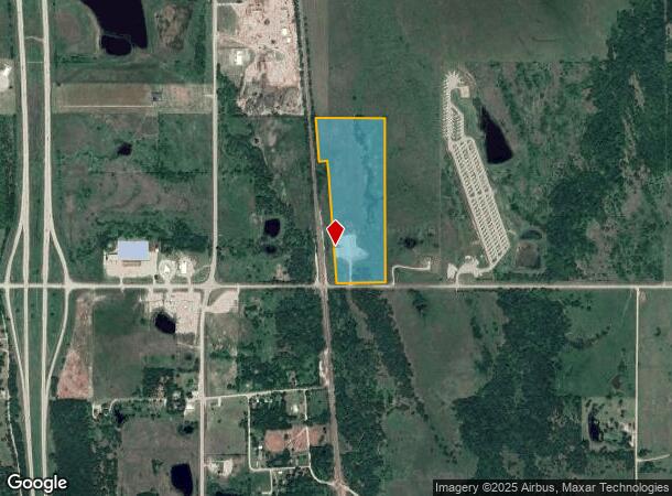
781 Lodge Rd
Ardmore, OK
Unplatted
0000-31-05S-02E-3-001-00
W/2 SE SW-SE SW SW LESS PT S/2 OF E 20 AC OF GOVT LOT 4 LYING E OF W LINE OF RR -PT SW NE SW & PT S/2 GOVT LOT 3 LYING E OF ELY ROW LINE OF RR-SW NE SW LYING E OF RR-LESS 2.20 AC TO RR-31 05S 02E
Shipyard
Carter
A
Oklahoma
40019C0600C
3,4
2024
29.73 AC
2025
Oklahoma East Area
893100
Other Market Areas
9,380 SF
DEMOGRAPHICS near 781 Lodge Rd
1 Mile
3 Mile
5 Mile
2024 Total Population
57
666
2,739
2029 Population
57
670
2,792
Pop Growth 2024-2029
0.00%
+ 0.60%
+ 1.94%
Average Age
44
42
41
2024 Total Households
23
264
1,045
HH Growth 2024-2029
0.00%
+ 0.38%
+ 1.91%
Median Household Inc
$59,999
$60,968
$70,591
Avg Household Size
2.30
2.50
2.60
2024 Avg HH Vehicles
2.00
2.00
2.00
Median Home Value
$179,999
$195,081
$223,518
Median Year Built
1980
1983
1986
Nearby Places
Map Layers
Map Styles
 Street
 Aerial
- Restaurants
- Banks
- Shops
- Fitness
- Groceries
PUBLIC TRANSPORTATION
COMMUTER RAIL
Ardmore Amtrak Station (Heartland Flyer - Amtrak)
DRIVE
WALK
Distance
Ardmore Amtrak Station (Heartland Flyer - Amtrak)
13 min
9.5 mi
Freight Ports
Tulsa Port of Inola
DRIVE
WALK
Distance
Tulsa Port of Inola
245 min
212.2 mi
SALE & LEASE HISTORY
LISTING DATE
SALE/LEASE

Feb 14, 2020
For Sale
Aug 14, 2020
For Sale
Nearby Properties
Address
Land Use
TOTAL SIZE
Lot Size
Zoning
Address
Land Use
TOTAL SIZE
Lot Size
Zoning
408 SF
78.62 AC
C1
Address
Land Use
TOTAL SIZE
Lot Size
Zoning
5,571 SF
37.97 AC
C1
Address
Land Use
TOTAL SIZE
Lot Size
Zoning
3,080 SF
5.17 AC
Address
Land Use
TOTAL SIZE
Lot Size
Zoning
4,419 SF
9.50 AC
R1
Address
Land Use
TOTAL SIZE
Lot Size
Zoning
640 SF
2.91 AC
C1
Address
Land Use
TOTAL SIZE
Lot Size
Zoning
3,000 SF
6.17 AC
C1
Address
Land Use
TOTAL SIZE
Lot Size
Zoning
5,580 SF
2 AC
R1
Address
Land Use
TOTAL SIZE
Lot Size
Zoning
448 SF
3.34 AC
C1
Address
Land Use
TOTAL SIZE
Lot Size
Zoning
357 SF
10 AC
C1
Address
Land Use
TOTAL SIZE
Lot Size
Zoning
12,000 SF
41.76 AC
NP
Address
Land Use
TOTAL SIZE
Lot Size
Zoning
4,560 SF
11.35 AC
C1
Address
Land Use
TOTAL SIZE
Lot Size
Zoning
3,964 SF
4.72 AC
C1
Address
Land Use
TOTAL SIZE
Lot Size
Zoning
10,818 SF
37.67 AC
C1
Address
Land Use
TOTAL SIZE
Lot Size
Zoning
4,948 SF
1 AC
Address
Land Use
TOTAL SIZE
Lot Size
Zoning
1,368 SF
19 AC
R1
Address
Land Use
TOTAL SIZE
Lot Size
Zoning
1,881 SF
157.96 AC
CR
Address
Land Use
TOTAL SIZE
Lot Size
Zoning
1,500 SF
R1
Address
Land Use
TOTAL SIZE
Lot Size
Zoning
4,372 SF
3 AC
C1
Address
Land Use
TOTAL SIZE
Lot Size
Zoning
3,200 SF
2.18 AC
IP
Address
Land Use
TOTAL SIZE
Lot Size
Zoning
2,481 SF
2 AC
C1
Address
Land Use
TOTAL SIZE
Lot Size
Zoning
580 SF
0.94 AC
C1
Address
Land Use
TOTAL SIZE
Lot Size
Zoning
1,140 SF
7.06 AC
C1
Address
Land Use
TOTAL SIZE
Lot Size
Zoning
12.07 AC
Address
Land Use
TOTAL SIZE
Lot Size
Zoning
1,336 SF
100 AC
R1
Address
Land Use
TOTAL SIZE
Lot Size
Zoning
3,200 SF
2.15 AC
Address
Land Use
TOTAL SIZE
Lot Size
Zoning
5.04 AC
C1
Address
Land Use
TOTAL SIZE
Lot Size
Zoning
924 SF
3.75 AC
R1
Address
Land Use
TOTAL SIZE
Lot Size
Zoning
5 AC
R1
The World's #1 Commercial Real Estate Marketplace
Connect with us
© 2025 CoStar Group
The information above has been obtained from sources believed reliable. While we do not doubt its accuracy we have not verified it and make no guarantee, warranty or representation about it. It is your responsibility to independently confirm its accuracy and completeness. Any projections, opinions, assumptions, or estimates used are for example only and do not represent the current or future performance of the property. The value of this transaction to you depends on tax and other factors which should be evaluated by your tax, financial, and legal advisors. You and your advisors should conduct a careful, independent investigation of the property to determine to your satisfaction the suitability of the property for your needs.