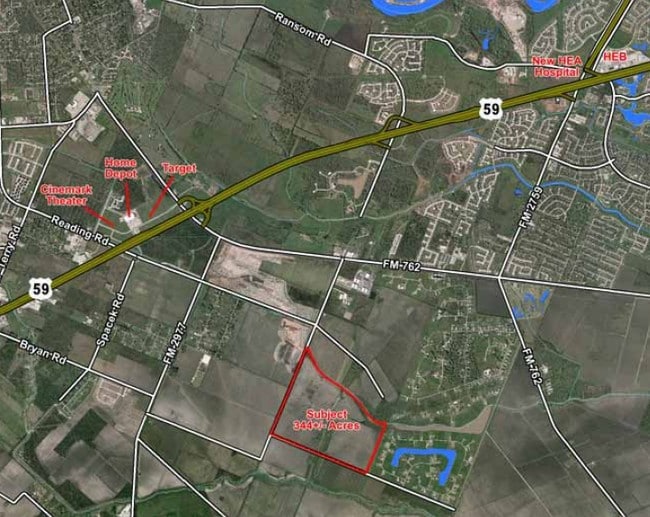
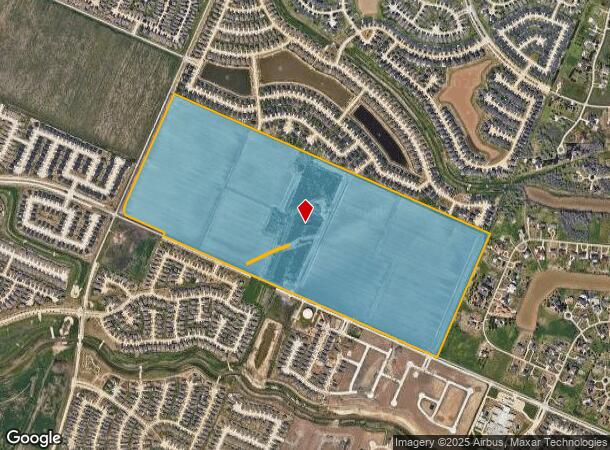
Property Record
7813 7815 A Meyers Rd, Richmond, TX 77469
NEARBY LISTINGS FOR SALE OR LEASE
Property Detail
7813 7815 A Meyers Rd
Houston-The Woodlands-Sugar Land, TX
Wiley Martin
0056-00-000-0060-901
0056 WILEY MARTIN, ACRES 194.5928
Commercialnec
Fort Bend
AE
Texas
48157C0265L
6
2024
200 AC
2025
Southwest Outlier
675502
Houston
864 SF
DEMOGRAPHICS near 7813 7815 A Meyers Rd
1 Mile
3 Mile
5 Mile
2024 Total Population
12,937
56,670
118,795
2029 Population
15,838
69,193
143,919
Pop Growth 2024-2029
+ 22.42%
+ 22.10%
+ 21.15%
Average Age
34
38
38
2024 Total Households
3,868
19,507
40,042
HH Growth 2024-2029
+ 22.93%
+ 22.79%
+ 21.82%
Median Household Inc
$108,021
$95,739
$81,565
Avg Household Size
3.40
2.90
2.90
2024 Avg HH Vehicles
2.00
2.00
2.00
Median Home Value
$294,045
$299,480
$284,997
Median Year Built
2011
2010
2005
Nearby Places
Map Layers
Map Styles
 Street
 Aerial
- Restaurants
- Banks
- Shops
- Fitness
- Groceries
PUBLIC TRANSPORTATION
AIRPORT
William P Hobby
DRIVE
WALK
Distance
William P Hobby
54 min
36.9 mi
Freight Ports
Port of Houston
DRIVE
WALK
Distance
Port of Houston
55 min
37.6 mi
Nearby Properties
Address
Land Use
TOTAL SIZE
Lot Size
Zoning
Address
Land Use
TOTAL SIZE
Lot Size
Zoning
50.46 AC
Address
Land Use
TOTAL SIZE
Lot Size
Zoning
133,259 SF
9.99 AC
Address
Land Use
TOTAL SIZE
Lot Size
Zoning
11.65 AC
Address
Land Use
TOTAL SIZE
Lot Size
Zoning
10.84 AC
Address
Land Use
TOTAL SIZE
Lot Size
Zoning
307,832 SF
14.06 AC
Address
Land Use
TOTAL SIZE
Lot Size
Zoning
15.95 AC
Address
Land Use
TOTAL SIZE
Lot Size
Zoning
13.21 AC
Address
Land Use
TOTAL SIZE
Lot Size
Zoning
573,314 SF
115.57 AC
Address
Land Use
TOTAL SIZE
Lot Size
Zoning
78,077 SF
16.29 AC
Address
Land Use
TOTAL SIZE
Lot Size
Zoning
85,021 SF
12 AC
Address
Land Use
TOTAL SIZE
Lot Size
Zoning
224,099 SF
11.85 AC
Address
Land Use
TOTAL SIZE
Lot Size
Zoning
11.40 AC
Address
Land Use
TOTAL SIZE
Lot Size
Zoning
129,092 SF
9.55 AC
Address
Land Use
TOTAL SIZE
Lot Size
Zoning
60.86 AC
Address
Land Use
TOTAL SIZE
Lot Size
Zoning
Address
Land Use
TOTAL SIZE
Lot Size
Zoning
16.48 AC
Address
Land Use
TOTAL SIZE
Lot Size
Zoning
12.21 AC
Address
Land Use
TOTAL SIZE
Lot Size
Zoning
14.92 AC
Address
Land Use
TOTAL SIZE
Lot Size
Zoning
2,131 SF
17.68 AC
Address
Land Use
TOTAL SIZE
Lot Size
Zoning
95,890 SF
14.26 AC
Address
Land Use
TOTAL SIZE
Lot Size
Zoning
86,856 SF
10 AC
X
Address
Land Use
TOTAL SIZE
Lot Size
Zoning
90,741 SF
11.82 AC
Address
Land Use
TOTAL SIZE
Lot Size
Zoning
123,941 SF
11.24 AC
Address
Land Use
TOTAL SIZE
Lot Size
Zoning
88,728 SF
5.04 AC
Address
Land Use
TOTAL SIZE
Lot Size
Zoning
132,171 SF
8.86 AC
Address
Land Use
TOTAL SIZE
Lot Size
Zoning
Address
Land Use
TOTAL SIZE
Lot Size
Zoning
Address
Land Use
TOTAL SIZE
Lot Size
Zoning
2.13 AC
Address
Land Use
TOTAL SIZE
Lot Size
Zoning
104,306 SF
7.59 AC
Address
Land Use
TOTAL SIZE
Lot Size
Zoning
60,391 SF
5.50 AC
The World's #1 Commercial Real Estate Marketplace
Connect with us
© 2025 CoStar Group
The information above has been obtained from sources believed reliable. While we do not doubt its accuracy we have not verified it and make no guarantee, warranty or representation about it. It is your responsibility to independently confirm its accuracy and completeness. Any projections, opinions, assumptions, or estimates used are for example only and do not represent the current or future performance of the property. The value of this transaction to you depends on tax and other factors which should be evaluated by your tax, financial, and legal advisors. You and your advisors should conduct a careful, independent investigation of the property to determine to your satisfaction the suitability of the property for your needs.