Property Record
Beulah Church Rd, Louisville, KY 40211
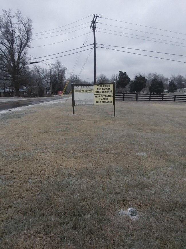
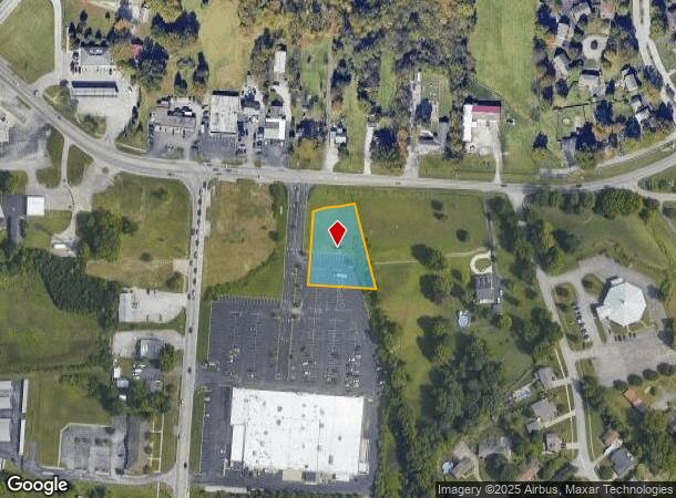
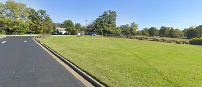
This Property Is For Sale
Current Lease Availabilities
NEARBY LISTINGS FOR SALE OR LEASE
Property Detail
Beulah Church Rd
064603570000
Jefferson
Storebuilding
Kentucky
X
0.77 AC
21111C0095F
South Central
2024
Louisville
2024
Louisville-Jefferson County, KY-IN
001000
DEMOGRAPHICS near Beulah Church Rd
1 Mile
3 Mile
5 Mile
2024 Total Population
9,722
68,644
180,190
2029 Population
9,586
67,823
178,073
Pop Growth 2024-2029
(1.40%)
(1.20%)
(1.17%)
Average Age
42
41
40
2024 Total Households
4,048
27,573
71,603
HH Growth 2024-2029
(1.51%)
(1.28%)
(1.26%)
Median Household Inc
$79,826
$73,656
$67,933
Avg Household Size
2.40
2.40
2.40
2024 Avg HH Vehicles
2.00
2.00
2.00
Median Home Value
$217,958
$221,136
$210,636
Median Year Built
1978
1985
1978
Nearby Places
- Restaurants
- Banks
- Shops
- Fitness
- Groceries
PUBLIC TRANSPORTATION
AIRPORT
Louisville Muhammad Ali International
DRIVE
WALK
Distance
Louisville Muhammad Ali International
18 min
9.9 mi
Freight Ports
Port of Toledo
DRIVE
WALK
Distance
Port of Toledo
362 min
309.7 mi
Nearby Properties
Address
Land Use
TOTAL SIZE
Lot Size
Zoning
Address
Land Use
TOTAL SIZE
Lot Size
Zoning
32.44 AC
Address
Land Use
TOTAL SIZE
Lot Size
Zoning
7,042 SF
30.40 AC
R5A-RESIDE
Address
Land Use
TOTAL SIZE
Lot Size
Zoning
1,450 SF
87.64 AC
M2-INDUSTR
Address
Land Use
TOTAL SIZE
Lot Size
Zoning
11.17 AC
R6-RESIDEN
Address
Land Use
TOTAL SIZE
Lot Size
Zoning
13.68 AC
Address
Land Use
TOTAL SIZE
Lot Size
Zoning
10.22 AC
C1-COMMERC
Address
Land Use
TOTAL SIZE
Lot Size
Zoning
401,443 SF
28.92 AC
M2-INDUSTR
Address
Land Use
TOTAL SIZE
Lot Size
Zoning
4,000 SF
15.46 AC
C2-COMMERC
Address
Land Use
TOTAL SIZE
Lot Size
Zoning
370,297 SF
28.31 AC
M2-INDUSTR
Address
Land Use
TOTAL SIZE
Lot Size
Zoning
4,344 SF
35.38 AC
R5A-RESIDE
Address
Land Use
TOTAL SIZE
Lot Size
Zoning
17,648 SF
8.96 AC
R6-RESIDEN
Address
Land Use
TOTAL SIZE
Lot Size
Zoning
22,076 SF
9.49 AC
R6-RESIDEN
Address
Land Use
TOTAL SIZE
Lot Size
Zoning
15.24 AC
Address
Land Use
TOTAL SIZE
Lot Size
Zoning
16,372 SF
9.75 AC
CN-NEIGHBO
Address
Land Use
TOTAL SIZE
Lot Size
Zoning
33,820 SF
11.87 AC
R6-RESIDEN
Address
Land Use
TOTAL SIZE
Lot Size
Zoning
14.13 AC
R4-RESIDEN
Address
Land Use
TOTAL SIZE
Lot Size
Zoning
Address
Land Use
TOTAL SIZE
Lot Size
Zoning
Address
Land Use
TOTAL SIZE
Lot Size
Zoning
6.97 AC
R4-RESIDEN
Address
Land Use
TOTAL SIZE
Lot Size
Zoning
220,847 SF
25.37 AC
C2-COMMERC
Address
Land Use
TOTAL SIZE
Lot Size
Zoning
Address
Land Use
TOTAL SIZE
Lot Size
Zoning
58,962 SF
18.40 AC
R4-RESIDEN
Address
Land Use
TOTAL SIZE
Lot Size
Zoning
1,526 SF
10.80 AC
R6-RESIDEN
Address
Land Use
TOTAL SIZE
Lot Size
Zoning
6.92 AC
C1-COMMERC
Address
Land Use
TOTAL SIZE
Lot Size
Zoning
15,006 SF
9.03 AC
R6-RESIDEN
Address
Land Use
TOTAL SIZE
Lot Size
Zoning
77,134 SF
6.97 AC
C1-COMMERC
Address
Land Use
TOTAL SIZE
Lot Size
Zoning
9,380 SF
10.99 AC
R6-RESIDEN
Address
Land Use
TOTAL SIZE
Lot Size
Zoning
6.78 AC
R6-RESIDEN
Address
Land Use
TOTAL SIZE
Lot Size
Zoning
576 SF
33.85 AC
R4-RESIDEN
Address
Land Use
TOTAL SIZE
Lot Size
Zoning
1,972 SF
92.61 AC
R4-RESIDEN
The World's #1 Commercial Real Estate Marketplace
Connect with us
© 2025 CoStar Group
The information above has been obtained from sources believed reliable. While we do not doubt its accuracy we have not verified it and make no guarantee, warranty or representation about it. It is your responsibility to independently confirm its accuracy and completeness. Any projections, opinions, assumptions, or estimates used are for example only and do not represent the current or future performance of the property. The value of this transaction to you depends on tax and other factors which should be evaluated by your tax, financial, and legal advisors. You and your advisors should conduct a careful, independent investigation of the property to determine to your satisfaction the suitability of the property for your needs.