Property Record
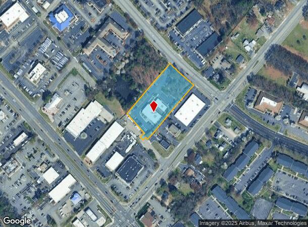
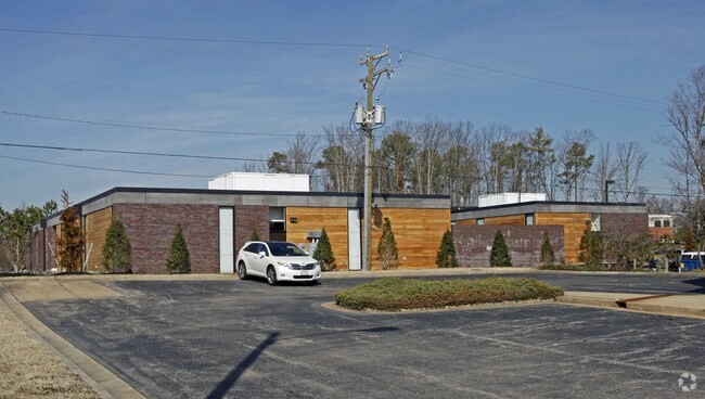
7813 Shrader Rd, Henrico, VA 23294


NEARBY LISTINGS FOR SALE OR LEASE
Property Detail
7813 Shrader Rd
764-752-9619
Woodlawn Farms
Medicalbuilding
0070100001 0002; WOODLAWN FARMS AC 1.910 93 A1 37
X
Henrico
5101290010E
Virginia
2025
1.91 AC
2025
Parham East
200409
Richmond VA
9,712 SF
Richmond, VA
DEMOGRAPHICS near 7813 Shrader Rd
1 Mile
3 Mile
5 Mile
2024 Total Population
13,743
96,759
212,349
2029 Population
13,769
96,568
212,653
Pop Growth 2024-2029
+ 0.19%
(0.20%)
+ 0.14%
Average Age
37
39
40
2024 Total Households
5,581
40,799
88,527
HH Growth 2024-2029
+ 0.20%
(0.17%)
+ 0.25%
Median Household Inc
$57,316
$72,773
$84,758
Avg Household Size
2.30
2.30
2.30
2024 Avg HH Vehicles
2.00
2.00
2.00
Median Home Value
$244,965
$282,135
$341,136
Median Year Built
1978
1976
1977
Nearby Places
Map Layers
Map Styles
 Street
 Aerial
- Restaurants
- Banks
- Shops
- Fitness
- Groceries
PUBLIC TRANSPORTATION
COMMUTER RAIL
Richmond Staples Mill Road Amtrak Station (Carolinian - Amtrak, Northeast Regional - Amtrak, Palmetto - Amtrak, Silver Meteor - Amtrak)
DRIVE
WALK
Distance
Richmond Staples Mill Road Amtrak Station (Carolinian - Amtrak, Northeast Regional - Amtrak, Palmetto - Amtrak, Silver Meteor - Amtrak)
5 min
2.0 mi
Richmond Main Street Amtrak Station (Northeast Regional - Amtrak)
DRIVE
WALK
Distance
Richmond Main Street Amtrak Station (Northeast Regional - Amtrak)
15 min
9.8 mi
AIRPORT
Richmond International
DRIVE
WALK
Distance
Richmond International
28 min
17.7 mi
Freight Ports
Virginia Port Authority - Richmond
DRIVE
WALK
Distance
Virginia Port Authority - Richmond
26 min
16.0 mi
Nearby Properties
Address
Land Use
TOTAL SIZE
Lot Size
Zoning
Address
Land Use
TOTAL SIZE
Lot Size
Zoning
172,000 SF
48.58 AC
R-3
Address
Land Use
TOTAL SIZE
Lot Size
Zoning
585,792 SF
38.94 AC
R-5
Address
Land Use
TOTAL SIZE
Lot Size
Zoning
597,042 SF
41.03 AC
R-6C
Address
Land Use
TOTAL SIZE
Lot Size
Zoning
382,570 SF
2.98 AC
UMUC
Address
Land Use
TOTAL SIZE
Lot Size
Zoning
568,334 SF
26.13 AC
MIXE
Address
Land Use
TOTAL SIZE
Lot Size
Zoning
173,400 SF
42 AC
MIXE
Address
Land Use
TOTAL SIZE
Lot Size
Zoning
527,410 SF
40.70 AC
A-1
Address
Land Use
TOTAL SIZE
Lot Size
Zoning
104,972 SF
108.49 AC
MIXE
Address
Land Use
TOTAL SIZE
Lot Size
Zoning
321,552 SF
UMUC
Address
Land Use
TOTAL SIZE
Lot Size
Zoning
266,138 SF
96.10 AC
R-2C
Address
Land Use
TOTAL SIZE
Lot Size
Zoning
184,760 SF
51.60 AC
A-1
Address
Land Use
TOTAL SIZE
Lot Size
Zoning
309,500 SF
29.78 AC
MIXE
Address
Land Use
TOTAL SIZE
Lot Size
Zoning
344,965 SF
28.33 AC
MIXE
Address
Land Use
TOTAL SIZE
Lot Size
Zoning
271,060 SF
18.31 AC
R-6
Address
Land Use
TOTAL SIZE
Lot Size
Zoning
2.51 AC
UMUC
Address
Land Use
TOTAL SIZE
Lot Size
Zoning
250,146 SF
20.41 AC
R-5
Address
Land Use
TOTAL SIZE
Lot Size
Zoning
1,404 SF
30.52 AC
R-5
Address
Land Use
TOTAL SIZE
Lot Size
Zoning
395,435 SF
13.26 AC
O-3C
Address
Land Use
TOTAL SIZE
Lot Size
Zoning
224,768 SF
18.08 AC
R-6
Address
Land Use
TOTAL SIZE
Lot Size
Zoning
296,784 SF
23.11 AC
R-5
Address
Land Use
TOTAL SIZE
Lot Size
Zoning
182,188 SF
21.84 AC
R-5
Address
Land Use
TOTAL SIZE
Lot Size
Zoning
257,130 SF
33.65 AC
B-3
Address
Land Use
TOTAL SIZE
Lot Size
Zoning
159,980 SF
21.38 AC
R-5C
Address
Land Use
TOTAL SIZE
Lot Size
Zoning
500,400 SF
31.15 AC
R-5
Address
Land Use
TOTAL SIZE
Lot Size
Zoning
232,368 SF
26.11 AC
R-5
Address
Land Use
TOTAL SIZE
Lot Size
Zoning
174,500 SF
8.57 AC
O-3
Address
Land Use
TOTAL SIZE
Lot Size
Zoning
182,264 SF
15.91 AC
R-5
Address
Land Use
TOTAL SIZE
Lot Size
Zoning
227,905 SF
58.94 AC
R-3
Address
Land Use
TOTAL SIZE
Lot Size
Zoning
371,568 SF
21.19 AC
R-5
Address
Land Use
TOTAL SIZE
Lot Size
Zoning
413,600 SF
36.28 AC
R-5
The World's #1 Commercial Real Estate Marketplace
Connect with us
© 2025 CoStar Group
The information above has been obtained from sources believed reliable. While we do not doubt its accuracy we have not verified it and make no guarantee, warranty or representation about it. It is your responsibility to independently confirm its accuracy and completeness. Any projections, opinions, assumptions, or estimates used are for example only and do not represent the current or future performance of the property. The value of this transaction to you depends on tax and other factors which should be evaluated by your tax, financial, and legal advisors. You and your advisors should conduct a careful, independent investigation of the property to determine to your satisfaction the suitability of the property for your needs.