Property Record
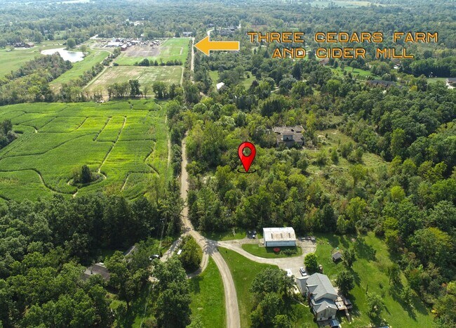
Stonegate Dr, Northville, MI 48167

This Property Is For Sale
NEARBY LISTINGS FOR SALE OR LEASE
-
-
No Photo
-
View all Northville listings for sale on LoopNet.com
Property Detail
Stonegate Dr
01-09-400-018
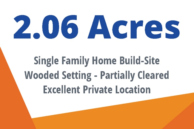
SM 9-16A-2A (002) COM AT SE COR SEC 9 TH W 856.28 FT, TH N 05-39-30 W 1989.44 FT TH CONT N 05-39-30 W 210 FT FOR POB, TH W 230 FT, TH N 390 FT, TH E 230 FT, TH S 390 FT TO POB, PART SE 1/4 SEC 9 T1S,R7E 2.06 AC
Residentialacreage
Washtenaw
X
Michigan
26161C0140E
2.06 AC
2025
Washtenaw E of 23
2025
Detroit
560100
Ann Arbor, MI
DEMOGRAPHICS near Stonegate Dr
1 Mile
3 Mile
5 Mile
2024 Total Population
525
7,901
44,849
2029 Population
512
7,845
44,485
Pop Growth 2024-2029
(2.48%)
(0.71%)
(0.81%)
Average Age
45
42
40
2024 Total Households
188
2,840
16,077
HH Growth 2024-2029
(2.66%)
(0.95%)
(0.96%)
Median Household Inc
$115,416
$110,592
$126,948
Avg Household Size
2.80
2.80
2.80
2024 Avg HH Vehicles
2.00
3.00
2.00
Median Home Value
$389,515
$401,206
$419,432
Median Year Built
1975
1993
1996
Nearby Places
- Restaurants
- Banks
- Shops
- Fitness
- Groceries
PUBLIC TRANSPORTATION
AIRPORT
Detroit Metro Wayne County
DRIVE
WALK
Distance
Detroit Metro Wayne County
40 min
30.4 mi
Freight Ports
Port of Toledo
DRIVE
WALK
Distance
Port of Toledo
90 min
72.0 mi
Nearby Properties
Address
Land Use
TOTAL SIZE
Lot Size
Zoning
Address
Land Use
TOTAL SIZE
Lot Size
Zoning
4,228 SF
105.74 AC
DI
Address
Land Use
TOTAL SIZE
Lot Size
Zoning
4,885 SF
67.51 AC
Address
Land Use
TOTAL SIZE
Lot Size
Zoning
61,746 SF
20.61 AC
Address
Land Use
TOTAL SIZE
Lot Size
Zoning
18,764 SF
415.68 AC
FH
Address
Land Use
TOTAL SIZE
Lot Size
Zoning
56,780 SF
5.13 AC
BI
Address
Land Use
TOTAL SIZE
Lot Size
Zoning
64.30 AC
AR AGR
Address
Land Use
TOTAL SIZE
Lot Size
Zoning
782 SF
29.85 AC
Address
Land Use
TOTAL SIZE
Lot Size
Zoning
10,031 SF
160 AC
MM
Address
Land Use
TOTAL SIZE
Lot Size
Zoning
10,000 SF
1.65 AC
BV
Address
Land Use
TOTAL SIZE
Lot Size
Zoning
19,530 SF
5.57 AC
BI
Address
Land Use
TOTAL SIZE
Lot Size
Zoning
6,800 SF
81.55 AC
II
Address
Land Use
TOTAL SIZE
Lot Size
Zoning
6,724 SF
80 AC
II
Address
Land Use
TOTAL SIZE
Lot Size
Zoning
20,214 SF
5.75 AC
Address
Land Use
TOTAL SIZE
Lot Size
Zoning
7,583 SF
184.35 AC
RC REC
Address
Land Use
TOTAL SIZE
Lot Size
Zoning
80 AC
SV
Address
Land Use
TOTAL SIZE
Lot Size
Zoning
6,360 SF
36.11 AC
Address
Land Use
TOTAL SIZE
Lot Size
Zoning
5 AC
RI
Address
Land Use
TOTAL SIZE
Lot Size
Zoning
21,459 SF
2.11 AC
BI
Address
Land Use
TOTAL SIZE
Lot Size
Zoning
20,000 SF
7 AC
II
Address
Land Use
TOTAL SIZE
Lot Size
Zoning
71.15 AC
FI
Address
Land Use
TOTAL SIZE
Lot Size
Zoning
6,000 SF
9.56 AC
Address
Land Use
TOTAL SIZE
Lot Size
Zoning
9,780 SF
6 AC
II
Address
Land Use
TOTAL SIZE
Lot Size
Zoning
8,197 SF
1.85 AC
BI
Address
Land Use
TOTAL SIZE
Lot Size
Zoning
Address
Land Use
TOTAL SIZE
Lot Size
Zoning
Address
Land Use
TOTAL SIZE
Lot Size
Zoning
2,732 SF
159.66 AC
FH
Address
Land Use
TOTAL SIZE
Lot Size
Zoning
78 AC
RI
Address
Land Use
TOTAL SIZE
Lot Size
Zoning
4,736 SF
225.64 AC
FH
Address
Land Use
TOTAL SIZE
Lot Size
Zoning
3,000 SF
51 AC
AR AGR
Address
Land Use
TOTAL SIZE
Lot Size
Zoning
3,511 SF
74.98 AC
ER
The World's #1 Commercial Real Estate Marketplace
Connect with us
© 2025 CoStar Group
The information above has been obtained from sources believed reliable. While we do not doubt its accuracy we have not verified it and make no guarantee, warranty or representation about it. It is your responsibility to independently confirm its accuracy and completeness. Any projections, opinions, assumptions, or estimates used are for example only and do not represent the current or future performance of the property. The value of this transaction to you depends on tax and other factors which should be evaluated by your tax, financial, and legal advisors. You and your advisors should conduct a careful, independent investigation of the property to determine to your satisfaction the suitability of the property for your needs.