Property Record
7815 Maris Rd, North Chesterfield, VA 23237
This Property Is For Sale
NEARBY LISTINGS FOR SALE OR LEASE
-
-
View all North Chesterfield listings for sale on LoopNet.com
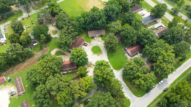
Property Detail
7815 Maris Rd
Richmond, VA
Bellwood Terrace
792-67-76-98-600-000
BELLWOOD TERR BK G RSB PAR A
Apartment
Chesterfield
A
Virginia
5101290100E
1
2025
4.35 AC
2025
Chesterfield County
100404
Richmond VA
13,104 SF
DEMOGRAPHICS near 7815 Maris Rd
1 Mile
3 Mile
5 Mile
2024 Total Population
3,491
37,835
101,716
2029 Population
3,843
41,415
110,043
Pop Growth 2024-2029
+ 10.08%
+ 9.46%
+ 8.19%
Average Age
37
38
39
2024 Total Households
1,431
13,688
37,996
HH Growth 2024-2029
+ 10.20%
+ 9.59%
+ 8.29%
Median Household Inc
$33,045
$57,601
$60,207
Avg Household Size
2.40
2.70
2.60
2024 Avg HH Vehicles
1.00
2.00
2.00
Median Home Value
$152,439
$239,719
$245,212
Median Year Built
1986
1980
1982
Nearby Places
- Restaurants
- Banks
- Shops
- Fitness
- Groceries
PUBLIC TRANSPORTATION
COMMUTER RAIL
Richmond Main Street Amtrak Station (Northeast Regional - Amtrak)
DRIVE
WALK
Distance
Richmond Main Street Amtrak Station (Northeast Regional - Amtrak)
15 min
8.9 mi
AIRPORT
Richmond International
DRIVE
WALK
Distance
Richmond International
22 min
13.6 mi
Freight Ports
Virginia Port Authority - Richmond
DRIVE
WALK
Distance
Virginia Port Authority - Richmond
12 min
6.2 mi
Nearby Properties
Address
Land Use
TOTAL SIZE
Lot Size
Zoning
Address
Land Use
TOTAL SIZE
Lot Size
Zoning
100 SF
652.52 AC
A - AGRICU
Address
Land Use
TOTAL SIZE
Lot Size
Zoning
231,168 SF
57.31 AC
R7 - SINGL
Address
Land Use
TOTAL SIZE
Lot Size
Zoning
413.51 AC
I3 - HVY I
Address
Land Use
TOTAL SIZE
Lot Size
Zoning
437,024 SF
39.40 AC
I3 - HVY I
Address
Land Use
TOTAL SIZE
Lot Size
Zoning
406,110 SF
57.69 AC
I3 - HVY I
Address
Land Use
TOTAL SIZE
Lot Size
Zoning
462,732 SF
24.94 AC
M-2 HEAVY
Address
Land Use
TOTAL SIZE
Lot Size
Zoning
448,888 SF
35.33 AC
M-2 HEAVY
Address
Land Use
TOTAL SIZE
Lot Size
Zoning
290,200 SF
50.99 AC
R7 - SINGL
Address
Land Use
TOTAL SIZE
Lot Size
Zoning
320,853 SF
33.68 AC
I3 - HVY I
Address
Land Use
TOTAL SIZE
Lot Size
Zoning
220,825 SF
55.17 AC
I3 - HVY I
Address
Land Use
TOTAL SIZE
Lot Size
Zoning
55,952 SF
11.82 AC
C3 - COMMU
Address
Land Use
TOTAL SIZE
Lot Size
Zoning
406,490 SF
19.58 AC
I3 - HVY I
Address
Land Use
TOTAL SIZE
Lot Size
Zoning
406,490 SF
33.22 AC
I3 - HVY I
Address
Land Use
TOTAL SIZE
Lot Size
Zoning
67,060 SF
4.93 AC
C5 - GEN B
Address
Land Use
TOTAL SIZE
Lot Size
Zoning
23,586 SF
41.23 AC
I2 - GEN I
Address
Land Use
TOTAL SIZE
Lot Size
Zoning
100 SF
15.43 AC
RMF - RES,
Address
Land Use
TOTAL SIZE
Lot Size
Zoning
103,863 SF
20.55 AC
R7 - SINGL
Address
Land Use
TOTAL SIZE
Lot Size
Zoning
86,564 SF
22.62 AC
M-2 HEAVY
Address
Land Use
TOTAL SIZE
Lot Size
Zoning
318,611 SF
24.17 AC
I3 - HVY I
Address
Land Use
TOTAL SIZE
Lot Size
Zoning
115,080 SF
124 AC
M-2 HEAVY
Address
Land Use
TOTAL SIZE
Lot Size
Zoning
138,860 SF
23.68 AC
RMF - RES,
Address
Land Use
TOTAL SIZE
Lot Size
Zoning
324,530 SF
31.47 AC
I3 - HVY I
Address
Land Use
TOTAL SIZE
Lot Size
Zoning
100 SF
10.85 AC
R7 - SINGL
Address
Land Use
TOTAL SIZE
Lot Size
Zoning
6.90 AC
R7 - SINGL
Address
Land Use
TOTAL SIZE
Lot Size
Zoning
5,412 SF
18.62 AC
C3 - COMMU
Address
Land Use
TOTAL SIZE
Lot Size
Zoning
100 SF
17.10 AC
RMF - RES,
Address
Land Use
TOTAL SIZE
Lot Size
Zoning
161,915 SF
21.43 AC
I3 - HVY I
Address
Land Use
TOTAL SIZE
Lot Size
Zoning
100 SF
7.70 AC
R7 - SINGL
Address
Land Use
TOTAL SIZE
Lot Size
Zoning
133,039 SF
10.40 AC
I3 - HVY I
Address
Land Use
TOTAL SIZE
Lot Size
Zoning
77,331 SF
11.54 AC
R7 - SINGL
The World's #1 Commercial Real Estate Marketplace
Connect with us
© 2025 CoStar Group
The information above has been obtained from sources believed reliable. While we do not doubt its accuracy we have not verified it and make no guarantee, warranty or representation about it. It is your responsibility to independently confirm its accuracy and completeness. Any projections, opinions, assumptions, or estimates used are for example only and do not represent the current or future performance of the property. The value of this transaction to you depends on tax and other factors which should be evaluated by your tax, financial, and legal advisors. You and your advisors should conduct a careful, independent investigation of the property to determine to your satisfaction the suitability of the property for your needs.