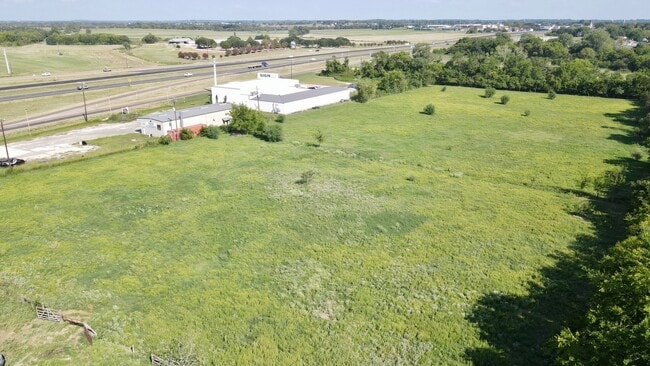
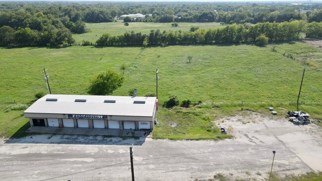
Property Record
7818 Highway 6 Loop, Navasota, TX 77868

Property Detail
7818 Highway 6 Loop
R10158
S8490 - VIVALDI SUBDIVISION, LOT 1-R, ACRES 4.214, (REPLAT 2022-326635)
Commercialnec
Grimes
1C
Texas
AE The base floodplain where base flood elevations are provided. AE Zones are now used on new format FIRMs instead of A1-A30 Zones.
1-r
2024
4.21 AC
2025
Central Texas Area
180201
Other Market Areas
3,990 SF
NEARBY LISTINGS FOR SALE OR LEASE
DEMOGRAPHICS near 7818 Highway 6 Loop
1 mile
3 mile
5 mile
2025 Total Population
3,030
8,943
11,066
2030 Population
3,361
9,932
12,307
Pop Growth 2025-2030
+ 10.92%
+ 11.06%
+ 11.21%
Average Age
39
40
40
2025 Total Households
1,103
3,282
4,069
HH Growth 2025-2030
+ 11.24%
+ 11.40%
+ 11.60%
Median Household Inc
$45,192
$54,267
$57,522
Avg Household Size
2.70
2.60
2.60
2025 Avg HH Vehicles
2.00
2.00
2.00
Median Home Value
$202,489
$189,164
$206,159
Median Year Built
1984
1984
1986
Nearby Places
Map Layers
Map Styles
 Street
 Aerial
Transit
 Traffic
 Biking
Places
Listings with unknown addresses are not visible on the map
- Restaurants
- Banks
- Shops
- Fitness
- Groceries
PUBLIC TRANSPORTATION
AIRPORT
Easterwood Field
Drive
Walk
Distance
Easterwood Field
39 min
26.9 mi
Freight Ports
Port of Houston
Drive
Walk
Distance
Port of Houston
98 min
76.7 mi
SALE & LEASE HISTORY
LISTING DATE
SALE/LEASE

Sep 27, 2022
For Sale
Oct 23, 2023
For Sale
Oct 06, 2025
For Sale
Nearby Properties
Address
Land Use
TOTAL SIZE
Lot Size
Zoning
Address
Land Use
TOTAL SIZE
Lot Size
Zoning
70.65 AC
1C
Address
Land Use
TOTAL SIZE
Lot Size
Zoning
267,353 SF
20 AC
1C
Address
Land Use
TOTAL SIZE
Lot Size
Zoning
47,579 SF
20.26 AC
Address
Land Use
TOTAL SIZE
Lot Size
Zoning
12.67 AC
1
Address
Land Use
TOTAL SIZE
Lot Size
Zoning
81,239 SF
3.77 AC
1C
Address
Land Use
TOTAL SIZE
Lot Size
Zoning
Address
Land Use
TOTAL SIZE
Lot Size
Zoning
Address
Land Use
TOTAL SIZE
Lot Size
Zoning
65,913 SF
2.62 AC
Address
Land Use
TOTAL SIZE
Lot Size
Zoning
101,643 SF
4.14 AC
1
Address
Land Use
TOTAL SIZE
Lot Size
Zoning
13.87 AC
2
Address
Land Use
TOTAL SIZE
Lot Size
Zoning
548 SF
3.46 AC
1
Address
Land Use
TOTAL SIZE
Lot Size
Zoning
Address
Land Use
TOTAL SIZE
Lot Size
Zoning
81,358 SF
11.62 AC
Address
Land Use
TOTAL SIZE
Lot Size
Zoning
1,216 SF
28.77 AC
5
Address
Land Use
TOTAL SIZE
Lot Size
Zoning
1,287,420 SF
82.07 AC
1
Address
Land Use
TOTAL SIZE
Lot Size
Zoning
39,200 SF
7.58 AC
2
Address
Land Use
TOTAL SIZE
Lot Size
Zoning
96.62 AC
Address
Land Use
TOTAL SIZE
Lot Size
Zoning
78,538 SF
7.91 AC
1C
Address
Land Use
TOTAL SIZE
Lot Size
Zoning
10.35 AC
Address
Land Use
TOTAL SIZE
Lot Size
Zoning
39,523 SF
2.87 AC
Address
Land Use
TOTAL SIZE
Lot Size
Zoning
70,326 SF
4.67 AC
Address
Land Use
TOTAL SIZE
Lot Size
Zoning
47,415 SF
4.60 AC
1C
Address
Land Use
TOTAL SIZE
Lot Size
Zoning
33,745 SF
5 AC
Address
Land Use
TOTAL SIZE
Lot Size
Zoning
23,750 SF
17.98 AC
1C
Address
Land Use
TOTAL SIZE
Lot Size
Zoning
31,227 SF
54.69 AC
1
Address
Land Use
TOTAL SIZE
Lot Size
Zoning
13,257 SF
5.95 AC
Address
Land Use
TOTAL SIZE
Lot Size
Zoning
6,753 SF
12.97 AC
Address
Land Use
TOTAL SIZE
Lot Size
Zoning
62,641 SF
640.36 AC
Address
Land Use
TOTAL SIZE
Lot Size
Zoning
38,592 SF
3.60 AC
1C
Address
Land Use
TOTAL SIZE
Lot Size
Zoning
The World's #1 Commercial Real Estate Marketplace
Connect with us
© 2026 CoStar Group
The information above has been obtained from sources believed reliable. While we do not doubt its accuracy we have not verified it and make no guarantee, warranty or representation about it. It is your responsibility to independently confirm its accuracy and completeness. Any projections, opinions, assumptions, or estimates used are for example only and do not represent the current or future performance of the property. The value of this transaction to you depends on tax and other factors which should be evaluated by your tax, financial, and legal advisors. You and your advisors should conduct a careful, independent investigation of the property to determine to your satisfaction the suitability of the property for your needs.