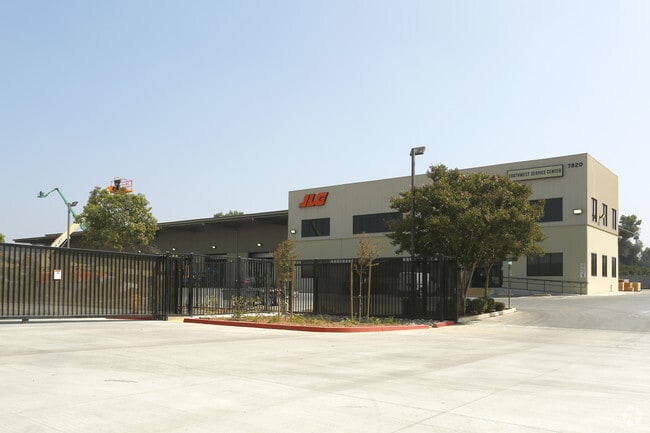
Property Record
7820 Lincoln Ave, Riverside, CA 92504


Save to a Folder
{{folder.Name}}
{{folder.ListingIds.length}} Properties
{{folder.ListingIds.length}} Property
Create a New Folder
Property Detail
7820 Lincoln Ave
Riverside-San Bernardino-Ontario, CA
6.46 ACRES M/L IN POR LOTS 1 & 2 BLK 51 MB 011/020 SB ARLINGTON HEIGHTS
237-040-021
RIVERSIDE
Lightindustrial
California
C and X Area of minimal flood hazard, usually depicted on FIRMs as above the 500-year flood level.
2
2024
6.46 AC
2025
Riverside
031701
Inland Empire (California)
54,130 SF
NEARBY LISTINGS FOR SALE OR LEASE
DEMOGRAPHICS near 7820 Lincoln Ave
1 mile
3 mile
5 mile
2025 Total Population
8,817
99,373
272,010
2030 Population
8,972
101,802
278,081
Pop Growth 2025-2030
+ 1.76%
+ 2.44%
+ 2.23%
Average Age
36
38
37
2025 Total Households
2,489
30,297
80,547
HH Growth 2025-2030
+ 1.33%
+ 2.00%
+ 1.79%
Median Household Inc
$82,945
$91,115
$93,265
Avg Household Size
3.30
3.10
3.20
2025 Avg HH Vehicles
2.00
2.00
2.00
Median Home Value
$517,751
$630,693
$661,331
Median Year Built
1967
1968
1975
Nearby Places
Map Layers
Map Styles
 Street
 Aerial
Layers
 Traffic
 Biking
Places
Listings with unknown addresses are not visible on the map
- Restaurants
- Banks
- Shops
- Fitness
- Groceries
PUBLIC TRANSPORTATION
COMMUTER RAIL
Riverside-Downtown (91 Line - Southern California Regional Rail Authority (Metrolink), Inland Empire-Orange County Line - Southern California Regional Rail Authority (Metrolink), Riverside Line - Southern California Regional Rail Authority (Metrolink))
Drive
Walk
Distance
Riverside-Downtown (91 Line - Southern California Regional Rail Authority (Metrolink), Inland Empire-Orange County Line - Southern California Regional Rail Authority (Metrolink), Riverside Line - Southern California Regional Rail Authority (Metrolink))
11 min
5.2 mi
Riverside-La Sierra (91 Line - Southern California Regional Rail Authority (Metrolink), Inland Empire-Orange County Line - Southern California Regional Rail Authority (Metrolink))
Drive
Walk
Distance
Riverside-La Sierra (91 Line - Southern California Regional Rail Authority (Metrolink), Inland Empire-Orange County Line - Southern California Regional Rail Authority (Metrolink))
11 min
5.7 mi
AIRPORT
Ontario International
Drive
Walk
Distance
Ontario International
30 min
17.6 mi
John Wayne/Orange County
Drive
Walk
Distance
John Wayne/Orange County
49 min
38.9 mi
Freight Ports
Port of Long Beach
Drive
Walk
Distance
Port of Long Beach
70 min
52.9 mi
Nearby Properties
Address
Land Use
TOTAL SIZE
Lot Size
Zoning
Address
Land Use
TOTAL SIZE
Lot Size
Zoning
412,950 SF
23.16 AC
C2
Address
Land Use
TOTAL SIZE
Lot Size
Zoning
154,680 SF
3.13 AC
R1
Address
Land Use
TOTAL SIZE
Lot Size
Zoning
45,862 SF
5.12 AC
Address
Land Use
TOTAL SIZE
Lot Size
Zoning
32,830 SF
6.66 AC
Address
Land Use
TOTAL SIZE
Lot Size
Zoning
169,980 SF
10.51 AC
C3
Address
Land Use
TOTAL SIZE
Lot Size
Zoning
37,729 SF
3.23 AC
Address
Land Use
TOTAL SIZE
Lot Size
Zoning
234,750 SF
13.31 AC
R3150
Address
Land Use
TOTAL SIZE
Lot Size
Zoning
129,739 SF
5.08 AC
Address
Land Use
TOTAL SIZE
Lot Size
Zoning
249,729 SF
15.60 AC
R3
Address
Land Use
TOTAL SIZE
Lot Size
Zoning
179,589 SF
18.62 AC
Address
Land Use
TOTAL SIZE
Lot Size
Zoning
8.75 AC
R1065
Address
Land Use
TOTAL SIZE
Lot Size
Zoning
127,770 SF
12.94 AC
Address
Land Use
TOTAL SIZE
Lot Size
Zoning
163,325 SF
6.42 AC
R1
Address
Land Use
TOTAL SIZE
Lot Size
Zoning
483,726 SF
3.47 AC
C2
Address
Land Use
TOTAL SIZE
Lot Size
Zoning
125,169 SF
5 AC
C1
Address
Land Use
TOTAL SIZE
Lot Size
Zoning
18,480 SF
7.19 AC
Address
Land Use
TOTAL SIZE
Lot Size
Zoning
40,024 SF
4.84 AC
Address
Land Use
TOTAL SIZE
Lot Size
Zoning
77,640 SF
10.11 AC
R1065
Address
Land Use
TOTAL SIZE
Lot Size
Zoning
54,046 SF
3.05 AC
Address
Land Use
TOTAL SIZE
Lot Size
Zoning
5,520 SF
4.24 AC
MP
Address
Land Use
TOTAL SIZE
Lot Size
Zoning
6.38 AC
Address
Land Use
TOTAL SIZE
Lot Size
Zoning
30,628 SF
7.58 AC
R1080
Address
Land Use
TOTAL SIZE
Lot Size
Zoning
621,300 SF
38.69 AC
MP
Address
Land Use
TOTAL SIZE
Lot Size
Zoning
106,685 SF
11.26 AC
Address
Land Use
TOTAL SIZE
Lot Size
Zoning
112,558 SF
9.19 AC
BMP
Address
Land Use
TOTAL SIZE
Lot Size
Zoning
6.25 AC
C3
Address
Land Use
TOTAL SIZE
Lot Size
Zoning
49,661 SF
3.71 AC
C-G
Address
Land Use
TOTAL SIZE
Lot Size
Zoning
75,822 SF
2.34 AC
The World's #1 Commercial Real Estate Marketplace
Connect with us
© 2026 CoStar Group
The information above has been obtained from sources believed reliable. While we do not doubt its accuracy we have not verified it and make no guarantee, warranty or representation about it. It is your responsibility to independently confirm its accuracy and completeness. Any projections, opinions, assumptions, or estimates used are for example only and do not represent the current or future performance of the property. The value of this transaction to you depends on tax and other factors which should be evaluated by your tax, financial, and legal advisors. You and your advisors should conduct a careful, independent investigation of the property to determine to your satisfaction the suitability of the property for your needs.