Property Record
7820 N Leadbetter Rd, Portland, OR 97203
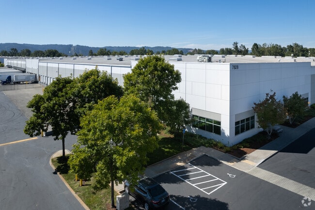

Property Detail
7820 N Leadbetter Rd
R518992
BYBEE LAKE INDUSTRIAL PARK, LOT 4 TL 400
Industrialgeneral
MULTNOMAH
IH
Oregon
C and X Area of minimal flood hazard, usually depicted on FIRMs as above the 500-year flood level.
4
2025
21.30 AC
2025
Rivergate
007202
Portland
438,700 SF
Portland-Vancouver-Hillsboro, OR-WA
NEARBY LISTINGS FOR SALE OR LEASE
DEMOGRAPHICS near 7820 N Leadbetter Rd
1 mile
3 mile
5 mile
2025 Total Population
21
13,893
77,197
2030 Population
22
13,667
77,632
Pop Growth 2025-2030
+ 4.76%
(1.63%)
+ 0.56%
Average Age
37
39
40
2025 Total Households
6
5,907
32,395
HH Growth 2025-2030
0.00%
(1.79%)
+ 0.90%
Median Household Inc
$59,999
$75,083
$85,881
Avg Household Size
1.80
2.20
2.20
2025 Avg HH Vehicles
2.00
2.00
2.00
Median Home Value
$99,999
$468,317
$496,686
Median Year Built
1979
1967
1968
Nearby Places
Map Layers
Map Styles
 Street
 Aerial
Transit
 Traffic
 Biking
Places
Listings with unknown addresses are not visible on the map
- Restaurants
- Banks
- Shops
- Fitness
- Groceries
PUBLIC TRANSPORTATION
COMMUTER RAIL
Drive
Walk
Distance
17 min
7.4 mi
AIRPORT
Portland International
Drive
Walk
Distance
Portland International
26 min
12.8 mi
SALE & LEASE HISTORY
LISTING DATE
SALE/LEASE

Sep 25, 2016
For Lease
Sep 22, 2021
For Lease
Oct 14, 2019
For Lease
Feb 26, 2019
For Lease
Feb 10, 2025
For Lease
Feb 05, 2024
For Lease
Feb 01, 2023
For Lease
Nearby Properties
Address
Land Use
TOTAL SIZE
Lot Size
Zoning
Address
Land Use
TOTAL SIZE
Lot Size
Zoning
546,069 SF
142 AC
IH
Address
Land Use
TOTAL SIZE
Lot Size
Zoning
332,800 SF
12.78 AC
IH
Address
Land Use
TOTAL SIZE
Lot Size
Zoning
890,408 SF
22.48 AC
IH
Address
Land Use
TOTAL SIZE
Lot Size
Zoning
262,045 SF
17.10 AC
R5
Address
Land Use
TOTAL SIZE
Lot Size
Zoning
Address
Land Use
TOTAL SIZE
Lot Size
Zoning
Address
Land Use
TOTAL SIZE
Lot Size
Zoning
335.31 AC
OS
Address
Land Use
TOTAL SIZE
Lot Size
Zoning
48.39 AC
NULL
Address
Land Use
TOTAL SIZE
Lot Size
Zoning
918,400 SF
48.13 AC
IH
Address
Land Use
TOTAL SIZE
Lot Size
Zoning
75.20 AC
IH
Address
Land Use
TOTAL SIZE
Lot Size
Zoning
Address
Land Use
TOTAL SIZE
Lot Size
Zoning
5,045,000 SF
116.53 AC
IH
Address
Land Use
TOTAL SIZE
Lot Size
Zoning
352,560 SF
18.34 AC
IL
Address
Land Use
TOTAL SIZE
Lot Size
Zoning
258,882 SF
15.50 AC
IL
Address
Land Use
TOTAL SIZE
Lot Size
Zoning
294,955 SF
14.10 AC
IL
Address
Land Use
TOTAL SIZE
Lot Size
Zoning
100 SF
82.93 AC
IH
Address
Land Use
TOTAL SIZE
Lot Size
Zoning
361,120 SF
20 AC
IH
Address
Land Use
TOTAL SIZE
Lot Size
Zoning
313,214 SF
NULL
Address
Land Use
TOTAL SIZE
Lot Size
Zoning
5,499,311 SF
40.90 AC
IH
Address
Land Use
TOTAL SIZE
Lot Size
Zoning
192,958 SF
10.28 AC
IL
Address
Land Use
TOTAL SIZE
Lot Size
Zoning
200 SF
50.40 AC
IH
Address
Land Use
TOTAL SIZE
Lot Size
Zoning
523,196 SF
21.97 AC
IHH
Address
Land Use
TOTAL SIZE
Lot Size
Zoning
425,395 SF
16.65 AC
IHH
Address
Land Use
TOTAL SIZE
Lot Size
Zoning
309,393 SF
14.87 AC
IH
Address
Land Use
TOTAL SIZE
Lot Size
Zoning
459,662 SF
19.41 AC
IHH
Address
Land Use
TOTAL SIZE
Lot Size
Zoning
385,275 SF
25.29 AC
IH
Address
Land Use
TOTAL SIZE
Lot Size
Zoning
573,020 SF
27.30 AC
IH
Address
Land Use
TOTAL SIZE
Lot Size
Zoning
96.34 AC
IH
Address
Land Use
TOTAL SIZE
Lot Size
Zoning
2,124 SF
417.17 AC
IH
Address
Land Use
TOTAL SIZE
Lot Size
Zoning
15 AC
IHH
The World's #1 Commercial Real Estate Marketplace
Connect with us
© 2026 CoStar Group
The information above has been obtained from sources believed reliable. While we do not doubt its accuracy we have not verified it and make no guarantee, warranty or representation about it. It is your responsibility to independently confirm its accuracy and completeness. Any projections, opinions, assumptions, or estimates used are for example only and do not represent the current or future performance of the property. The value of this transaction to you depends on tax and other factors which should be evaluated by your tax, financial, and legal advisors. You and your advisors should conduct a careful, independent investigation of the property to determine to your satisfaction the suitability of the property for your needs.