Property Record
7820 Quivira Rd, Shawnee, KS 66216

NEARBY LISTINGS FOR SALE OR LEASE
Property Detail
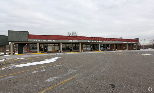
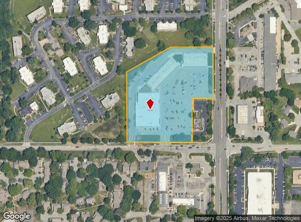
7820 Quivira Rd
IF241222-4008
22-12-24 PT SE1/4 SE1/4 BG SE CR N 635' W 318.45' SW 313.42'S 471.18' E 586.2' TO POB EX .816 AC EX .027 AC IN ST EX S 40' & E 50' S 500' IN STS & EX .152AC IN ST 6.009 ACS M/L LEC 4
Regionalshoppingcenterormallwithanchorstore
Johnson
X
Kansas
20091C0036G
5.87 AC
2024
Northwest Johnson County
2024
Kansas City
052419
Kansas City, MO-KS
53,625 SF
DEMOGRAPHICS near 7820 Quivira Rd
1 Mile
3 Mile
5 Mile
2024 Total Population
14,068
101,997
211,186
2029 Population
14,724
105,885
219,002
Pop Growth 2024-2029
+ 4.66%
+ 3.81%
+ 3.70%
Average Age
38
40
41
2024 Total Households
6,389
44,153
93,051
HH Growth 2024-2029
+ 4.73%
+ 3.96%
+ 3.89%
Median Household Inc
$64,851
$73,707
$77,403
Avg Household Size
2.10
2.20
2.20
2024 Avg HH Vehicles
2.00
2.00
2.00
Median Home Value
$267,062
$257,441
$274,270
Median Year Built
1977
1975
1974
Nearby Places
Map Layers
Map Styles
 Street
 Aerial
- Restaurants
- Banks
- Shops
- Fitness
- Groceries
PUBLIC TRANSPORTATION
AIRPORT
Kansas City International
DRIVE
WALK
Distance
Kansas City International
41 min
30.3 mi
SALE & LEASE HISTORY
LISTING DATE
SALE/LEASE

Sep 24, 2016
For Lease
Jun 28, 2024
For Lease
Nearby Properties
Address
Land Use
TOTAL SIZE
Lot Size
Zoning
Address
Land Use
TOTAL SIZE
Lot Size
Zoning
857,568 SF
38.48 AC
PUD-G
Address
Land Use
TOTAL SIZE
Lot Size
Zoning
740,953 SF
88.91 AC
RP5
Address
Land Use
TOTAL SIZE
Lot Size
Zoning
279,588 SF
19.50 AC
RP5
Address
Land Use
TOTAL SIZE
Lot Size
Zoning
203,079 SF
8.10 AC
BP2
Address
Land Use
TOTAL SIZE
Lot Size
Zoning
202,842 SF
10.20 AC
PD
Address
Land Use
TOTAL SIZE
Lot Size
Zoning
234,968 SF
37.40 AC
R-1
Address
Land Use
TOTAL SIZE
Lot Size
Zoning
133,505 SF
16.41 AC
R-1
Address
Land Use
TOTAL SIZE
Lot Size
Zoning
166,039 SF
35.38 AC
R-1
Address
Land Use
TOTAL SIZE
Lot Size
Zoning
96,501 SF
6.49 AC
Address
Land Use
TOTAL SIZE
Lot Size
Zoning
81,762 SF
9.66 AC
R-1
Address
Land Use
TOTAL SIZE
Lot Size
Zoning
120,492 SF
10 AC
R1
Address
Land Use
TOTAL SIZE
Lot Size
Zoning
146,143 SF
10.59 AC
CP-2
Address
Land Use
TOTAL SIZE
Lot Size
Zoning
411,435 SF
17.41 AC
CP-2
Address
Land Use
TOTAL SIZE
Lot Size
Zoning
89,477 SF
16.45 AC
R-1
Address
Land Use
TOTAL SIZE
Lot Size
Zoning
75,010 SF
5.53 AC
PD
Address
Land Use
TOTAL SIZE
Lot Size
Zoning
72,994 SF
7.99 AC
RP3
Address
Land Use
TOTAL SIZE
Lot Size
Zoning
85,703 SF
7.84 AC
R-1
Address
Land Use
TOTAL SIZE
Lot Size
Zoning
49,282 SF
11.89 AC
RP1
Address
Land Use
TOTAL SIZE
Lot Size
Zoning
85,940 SF
9.08 AC
RGA
Address
Land Use
TOTAL SIZE
Lot Size
Zoning
96,856 SF
15.76 AC
R-1
Address
Land Use
TOTAL SIZE
Lot Size
Zoning
89,002 SF
8.77 AC
R-1
Address
Land Use
TOTAL SIZE
Lot Size
Zoning
139,880 SF
17.18 AC
R1
Address
Land Use
TOTAL SIZE
Lot Size
Zoning
79,737 SF
11.90 AC
R-1
Address
Land Use
TOTAL SIZE
Lot Size
Zoning
88,866 SF
21.54 AC
RS
Address
Land Use
TOTAL SIZE
Lot Size
Zoning
81,361 SF
3.81 AC
AG
Address
Land Use
TOTAL SIZE
Lot Size
Zoning
37,499 SF
3.72 AC
PUD-G
Address
Land Use
TOTAL SIZE
Lot Size
Zoning
70,952 SF
9.98 AC
R-1
Address
Land Use
TOTAL SIZE
Lot Size
Zoning
85,469 SF
10.32 AC
CPO
Address
Land Use
TOTAL SIZE
Lot Size
Zoning
77,758 SF
4.89 AC
R-1
Address
Land Use
TOTAL SIZE
Lot Size
Zoning
35,848 SF
74.74 AC
R1
The World's #1 Commercial Real Estate Marketplace
Connect with us
© 2025 CoStar Group
The information above has been obtained from sources believed reliable. While we do not doubt its accuracy we have not verified it and make no guarantee, warranty or representation about it. It is your responsibility to independently confirm its accuracy and completeness. Any projections, opinions, assumptions, or estimates used are for example only and do not represent the current or future performance of the property. The value of this transaction to you depends on tax and other factors which should be evaluated by your tax, financial, and legal advisors. You and your advisors should conduct a careful, independent investigation of the property to determine to your satisfaction the suitability of the property for your needs.