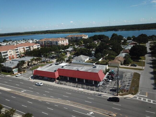
Property Record
7843 Seminole Blvd, Seminole, FL 33772


Current Lease Availabilities
NEARBY LISTINGS FOR SALE OR LEASE
Property Detail
7843 Seminole Blvd
Tampa-St. Petersburg-Clearwater, FL
Lake Seminole Vista Sub
27-30-15-48420-000-0250
LAKE SEMINOLE VISTA SUB LOTS 25 & 42
Regionalshoppingcenterormallwithanchorstore
Pinellas
X
Florida
12103C0183H
25,42
2024
0.68 AC
2025
Mid-Pinellas
025111
Tampa/St Petersburg
10,905 SF
DEMOGRAPHICS near 7843 Seminole Blvd
1 Mile
3 Mile
5 Mile
2024 Total Population
11,760
86,792
217,578
2029 Population
11,947
87,311
219,243
Pop Growth 2024-2029
+ 1.59%
+ 0.60%
+ 0.77%
Average Age
53
49
48
2024 Total Households
6,255
40,272
99,618
HH Growth 2024-2029
+ 1.63%
+ 0.62%
+ 0.81%
Median Household Inc
$51,655
$67,825
$63,545
Avg Household Size
1.80
2.10
2.10
2024 Avg HH Vehicles
1.00
2.00
2.00
Median Home Value
$238,253
$299,355
$276,951
Median Year Built
1975
1975
1975
Nearby Places
Map Layers
Map Styles
 Street
 Aerial
- Restaurants
- Banks
- Shops
- Fitness
- Groceries
PUBLIC TRANSPORTATION
AIRPORT
St Pete-Clearwater International
DRIVE
WALK
Distance
St Pete-Clearwater International
26 min
11.8 mi
Tampa International
DRIVE
WALK
Distance
Tampa International
37 min
23.2 mi
Freight Ports
Port Manatee
DRIVE
WALK
Distance
Port Manatee
51 min
33.8 mi
Nearby Properties
Address
Land Use
TOTAL SIZE
Lot Size
Zoning
Address
Land Use
TOTAL SIZE
Lot Size
Zoning
2,167,184 SF
297.75 AC
PSP
Address
Land Use
TOTAL SIZE
Lot Size
Zoning
459,848 SF
19.74 AC
R6
Address
Land Use
TOTAL SIZE
Lot Size
Zoning
372,952 SF
31.56 AC
Address
Land Use
TOTAL SIZE
Lot Size
Zoning
453,486 SF
15.73 AC
Address
Land Use
TOTAL SIZE
Lot Size
Zoning
328,466 SF
18.81 AC
Address
Land Use
TOTAL SIZE
Lot Size
Zoning
223,748 SF
100.32 AC
R3
Address
Land Use
TOTAL SIZE
Lot Size
Zoning
101,642 SF
1.43 AC
Address
Land Use
TOTAL SIZE
Lot Size
Zoning
227,858 SF
64.31 AC
AE
Address
Land Use
TOTAL SIZE
Lot Size
Zoning
206,685 SF
16.75 AC
RPD5
Address
Land Use
TOTAL SIZE
Lot Size
Zoning
582,271 SF
17.14 AC
Address
Land Use
TOTAL SIZE
Lot Size
Zoning
10,474 SF
660.47 AC
R3
Address
Land Use
TOTAL SIZE
Lot Size
Zoning
261,486 SF
30.21 AC
RPD20
Address
Land Use
TOTAL SIZE
Lot Size
Zoning
194,610 SF
36.55 AC
R3
Address
Land Use
TOTAL SIZE
Lot Size
Zoning
267,730 SF
35.84 AC
AE
Address
Land Use
TOTAL SIZE
Lot Size
Zoning
6,098 SF
374.66 AC
AE
Address
Land Use
TOTAL SIZE
Lot Size
Zoning
174,082 SF
17.08 AC
C2
Address
Land Use
TOTAL SIZE
Lot Size
Zoning
5,647 SF
187.56 AC
AE
Address
Land Use
TOTAL SIZE
Lot Size
Zoning
29,644 SF
19.13 AC
Address
Land Use
TOTAL SIZE
Lot Size
Zoning
159,667 SF
20 AC
AE
Address
Land Use
TOTAL SIZE
Lot Size
Zoning
160,086 SF
1.18 AC
Address
Land Use
TOTAL SIZE
Lot Size
Zoning
204,891 SF
18.20 AC
Address
Land Use
TOTAL SIZE
Lot Size
Zoning
236,240 SF
12.38 AC
RPD15
Address
Land Use
TOTAL SIZE
Lot Size
Zoning
222,888 SF
11.83 AC
RPD15
Address
Land Use
TOTAL SIZE
Lot Size
Zoning
385,858 SF
8.83 AC
Address
Land Use
TOTAL SIZE
Lot Size
Zoning
276,561 SF
12.24 AC
Address
Land Use
TOTAL SIZE
Lot Size
Zoning
130,331 SF
12.83 AC
C2
Address
Land Use
TOTAL SIZE
Lot Size
Zoning
176,209 SF
27.52 AC
Address
Land Use
TOTAL SIZE
Lot Size
Zoning
440 SF
3.47 AC
Address
Land Use
TOTAL SIZE
Lot Size
Zoning
160,134 SF
18.61 AC
R2
Address
Land Use
TOTAL SIZE
Lot Size
Zoning
137,240 SF
11.38 AC
RPD125
The World's #1 Commercial Real Estate Marketplace
Connect with us
© 2025 CoStar Group
The information above has been obtained from sources believed reliable. While we do not doubt its accuracy we have not verified it and make no guarantee, warranty or representation about it. It is your responsibility to independently confirm its accuracy and completeness. Any projections, opinions, assumptions, or estimates used are for example only and do not represent the current or future performance of the property. The value of this transaction to you depends on tax and other factors which should be evaluated by your tax, financial, and legal advisors. You and your advisors should conduct a careful, independent investigation of the property to determine to your satisfaction the suitability of the property for your needs.