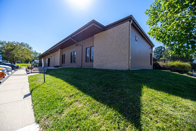
Property Record
7825 W 38Th Ave, Wheat Ridge, CO 80033

NEARBY LISTINGS FOR SALE OR LEASE
Property Detail
7825 W 38Th Ave
Denver-Aurora-Lakewood, CO
Zephyr Medical Commons
39-233-21-013
SECTION 23 TOWNSHIP 03 RANGE 69 QTR SW SUBDIVISIONCD 860600 SUBDIVISIONNAME ZEPHYR MEDICAL COMMONS BLOCK LOT 0006 TRACT
Commercialcondominium
Jefferson
X
Colorado
08059C0214G
6
2023
0.02 AC
2024
West Denver
010502
Denver
991 SF
DEMOGRAPHICS near 7825 W 38Th Ave
1 Mile
3 Mile
5 Mile
2024 Total Population
11,985
130,782
354,977
2029 Population
12,017
130,881
357,007
Pop Growth 2024-2029
+ 0.27%
+ 0.08%
+ 0.57%
Average Age
45
40
39
2024 Total Households
5,576
59,508
156,004
HH Growth 2024-2029
+ 0.27%
(0.01%)
+ 0.64%
Median Household Inc
$74,564
$77,018
$81,634
Avg Household Size
2.10
2.10
2.20
2024 Avg HH Vehicles
2.00
2.00
2.00
Median Home Value
$563,672
$583,834
$555,871
Median Year Built
1962
1966
1972
Nearby Places
Map Layers
Map Styles
 Street
 Aerial
- Restaurants
- Banks
- Shops
- Fitness
- Groceries
PUBLIC TRANSPORTATION
COMMUTER RAIL
DRIVE
WALK
Distance
5 min
2.3 mi
DRIVE
WALK
Distance
5 min
2.4 mi
AIRPORT
Denver International
DRIVE
WALK
Distance
Denver International
37 min
28.4 mi
SALE & LEASE HISTORY
LISTING DATE
SALE/LEASE

Sep 24, 2021
For Sale
Oct 06, 2023
For Sale
Nov 23, 2016
For Lease
Nov 08, 2024
For Sale
Feb 06, 2023
For Lease
Feb 03, 2025
For Sale
Nearby Properties
Address
Land Use
TOTAL SIZE
Lot Size
Zoning
Address
Land Use
TOTAL SIZE
Lot Size
Zoning
111,673 SF
29.06 AC
Address
Land Use
TOTAL SIZE
Lot Size
Zoning
298,150 SF
24.21 AC
Address
Land Use
TOTAL SIZE
Lot Size
Zoning
187,095 SF
23.42 AC
Address
Land Use
TOTAL SIZE
Lot Size
Zoning
187,745 SF
16.25 AC
Address
Land Use
TOTAL SIZE
Lot Size
Zoning
247,459 SF
2.31 AC
C-MX-8
Address
Land Use
TOTAL SIZE
Lot Size
Zoning
202,867 SF
2.28 AC
C-MX
Address
Land Use
TOTAL SIZE
Lot Size
Zoning
436,238 SF
13.94 AC
Address
Land Use
TOTAL SIZE
Lot Size
Zoning
310,267 SF
1.69 AC
C-MX
Address
Land Use
TOTAL SIZE
Lot Size
Zoning
212,995 SF
3.20 AC
R-3
Address
Land Use
TOTAL SIZE
Lot Size
Zoning
167,420 SF
5.84 AC
Address
Land Use
TOTAL SIZE
Lot Size
Zoning
389,561 SF
10.73 AC
Address
Land Use
TOTAL SIZE
Lot Size
Zoning
142,635 SF
6.84 AC
U-SU-B1
Address
Land Use
TOTAL SIZE
Lot Size
Zoning
100,615 SF
2.28 AC
Address
Land Use
TOTAL SIZE
Lot Size
Zoning
131,135 SF
2.83 AC
Address
Land Use
TOTAL SIZE
Lot Size
Zoning
262,699 SF
13.10 AC
A2
Address
Land Use
TOTAL SIZE
Lot Size
Zoning
311,200 SF
0.85 AC
Address
Land Use
TOTAL SIZE
Lot Size
Zoning
138,204 SF
3.68 AC
Address
Land Use
TOTAL SIZE
Lot Size
Zoning
76,078 SF
6.64 AC
U-SU-C
Address
Land Use
TOTAL SIZE
Lot Size
Zoning
330,357 SF
15.16 AC
Address
Land Use
TOTAL SIZE
Lot Size
Zoning
111,478 SF
8.24 AC
CMP
Address
Land Use
TOTAL SIZE
Lot Size
Zoning
241,243 SF
9.08 AC
Address
Land Use
TOTAL SIZE
Lot Size
Zoning
87,567 SF
14.98 AC
R-5
Address
Land Use
TOTAL SIZE
Lot Size
Zoning
115,719 SF
5.93 AC
Address
Land Use
TOTAL SIZE
Lot Size
Zoning
142,200 SF
9.82 AC
Address
Land Use
TOTAL SIZE
Lot Size
Zoning
7,826 SF
0.48 AC
Address
Land Use
TOTAL SIZE
Lot Size
Zoning
2,997 SF
5.28 AC
Address
Land Use
TOTAL SIZE
Lot Size
Zoning
73,915 SF
2.89 AC
U-TU-C
Address
Land Use
TOTAL SIZE
Lot Size
Zoning
163,361 SF
17.09 AC
Address
Land Use
TOTAL SIZE
Lot Size
Zoning
125,884 SF
8.88 AC
Address
Land Use
TOTAL SIZE
Lot Size
Zoning
91,734 SF
9.69 AC
The World's #1 Commercial Real Estate Marketplace
Connect with us
© 2025 CoStar Group
The information above has been obtained from sources believed reliable. While we do not doubt its accuracy we have not verified it and make no guarantee, warranty or representation about it. It is your responsibility to independently confirm its accuracy and completeness. Any projections, opinions, assumptions, or estimates used are for example only and do not represent the current or future performance of the property. The value of this transaction to you depends on tax and other factors which should be evaluated by your tax, financial, and legal advisors. You and your advisors should conduct a careful, independent investigation of the property to determine to your satisfaction the suitability of the property for your needs.