Property Record
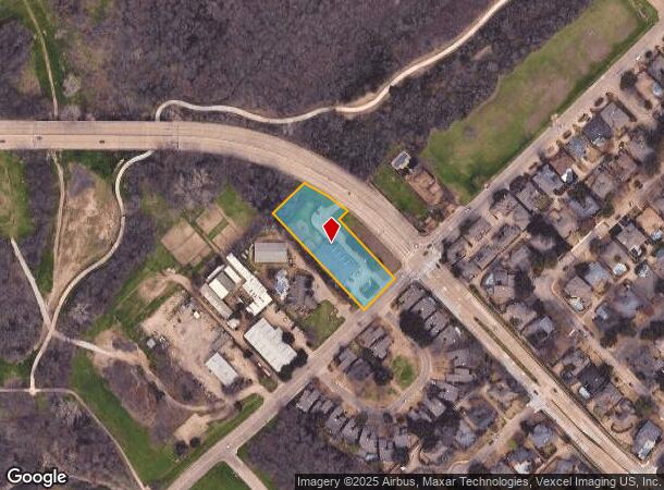
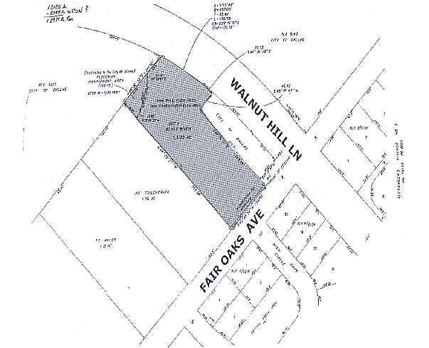
7825 Fair Oaks Ave, Dallas, TX 75231

NEARBY LISTINGS FOR SALE OR LEASE
Property Detail
7825 Fair Oaks Ave
Dallas-Fort Worth-Arlington, TX
Fair Oaks Private School Addn
0052150B000010000
FAIR OAKS PRIVATE SCHOOL ADDN BLK B/5215 LOT 1 1.2971 ACS INT202100195788 DD06242021 CO-DC 5215 B00 00100 7DA5215 B00
Daycare
Dallas
AE
Texas
48113C0215K
1
2024
1.30 AC
2025
Upper Greenville
007812
Dallas/Ft Worth
8,228 SF
DEMOGRAPHICS near 7825 Fair Oaks Ave
1 Mile
3 Mile
5 Mile
2024 Total Population
20,118
172,865
391,082
2029 Population
20,142
172,818
389,679
Pop Growth 2024-2029
+ 0.12%
(0.03%)
(0.36%)
Average Age
35
37
37
2024 Total Households
8,269
79,756
163,842
HH Growth 2024-2029
+ 0.21%
(0.04%)
(0.35%)
Median Household Inc
$49,731
$58,916
$68,700
Avg Household Size
2.40
2.10
2.30
2024 Avg HH Vehicles
1.00
1.00
2.00
Median Home Value
$466,841
$480,480
$489,824
Median Year Built
1978
1980
1977
Nearby Places
Map Layers
Map Styles
 Street
 Aerial
- Restaurants
- Banks
- Shops
- Fitness
- Groceries
PUBLIC TRANSPORTATION
COMMUTER RAIL
DRIVE
WALK
Distance
13 min
9.1 mi
AIRPORT
Dallas Love Field
DRIVE
WALK
Distance
Dallas Love Field
19 min
9.2 mi
Dallas-Fort Worth International
DRIVE
WALK
Distance
Dallas-Fort Worth International
34 min
25.9 mi
Nearby Properties
Address
Land Use
TOTAL SIZE
Lot Size
Zoning
Address
Land Use
TOTAL SIZE
Lot Size
Zoning
4,157,377 SF
76.79 AC
Z248
Address
Land Use
TOTAL SIZE
Lot Size
Zoning
2,186,362 SF
48.27 AC
Z239
Address
Land Use
TOTAL SIZE
Lot Size
Zoning
502,529 SF
3.08 AC
Z239
Address
Land Use
TOTAL SIZE
Lot Size
Zoning
1,252,860 SF
57.08 AC
Z239
Address
Land Use
TOTAL SIZE
Lot Size
Zoning
3,423,779 SF
32.42 AC
Z151
Address
Land Use
TOTAL SIZE
Lot Size
Zoning
77.76 AC
Z239
Address
Land Use
TOTAL SIZE
Lot Size
Zoning
1,086,919 SF
5.85 AC
Z239
Address
Land Use
TOTAL SIZE
Lot Size
Zoning
557,392 SF
10.06 AC
Z239
Address
Land Use
TOTAL SIZE
Lot Size
Zoning
395,377 SF
14.61 AC
Z163
Address
Land Use
TOTAL SIZE
Lot Size
Zoning
835,301 SF
9.29 AC
Z239
Address
Land Use
TOTAL SIZE
Lot Size
Zoning
674,474 SF
18.81 AC
Z164
Address
Land Use
TOTAL SIZE
Lot Size
Zoning
776,707 SF
8.47 AC
Address
Land Use
TOTAL SIZE
Lot Size
Zoning
717,809 SF
4.88 AC
Z239
Address
Land Use
TOTAL SIZE
Lot Size
Zoning
421,798 SF
9 AC
Z151
Address
Land Use
TOTAL SIZE
Lot Size
Zoning
852,562 SF
13.86 AC
Z151
Address
Land Use
TOTAL SIZE
Lot Size
Zoning
399,256 SF
13.19 AC
Z164
Address
Land Use
TOTAL SIZE
Lot Size
Zoning
184,388 SF
18.89 AC
Z298
Address
Land Use
TOTAL SIZE
Lot Size
Zoning
485,067 SF
14.87 AC
Z239
Address
Land Use
TOTAL SIZE
Lot Size
Zoning
611,288 SF
8.80 AC
Z163
Address
Land Use
TOTAL SIZE
Lot Size
Zoning
462,916 SF
15.67 AC
Z248
Address
Land Use
TOTAL SIZE
Lot Size
Zoning
249,692 SF
244.62 AC
Z239
Address
Land Use
TOTAL SIZE
Lot Size
Zoning
1,009,203 SF
33.32 AC
Z125
Address
Land Use
TOTAL SIZE
Lot Size
Zoning
441,400 SF
6.56 AC
Z239
Address
Land Use
TOTAL SIZE
Lot Size
Zoning
302,553 SF
15.59 AC
Z164
Address
Land Use
TOTAL SIZE
Lot Size
Zoning
403,339 SF
16.42 AC
Z239
Address
Land Use
TOTAL SIZE
Lot Size
Zoning
595,526 SF
6.92 AC
Z151
Address
Land Use
TOTAL SIZE
Lot Size
Zoning
336,786 SF
4.30 AC
Z239
Address
Land Use
TOTAL SIZE
Lot Size
Zoning
592,314 SF
4.19 AC
Z96
Address
Land Use
TOTAL SIZE
Lot Size
Zoning
819,202 SF
15.47 AC
Z163
Address
Land Use
TOTAL SIZE
Lot Size
Zoning
456,300 SF
10.92 AC
Z239
The World's #1 Commercial Real Estate Marketplace
Connect with us
© 2025 CoStar Group
The information above has been obtained from sources believed reliable. While we do not doubt its accuracy we have not verified it and make no guarantee, warranty or representation about it. It is your responsibility to independently confirm its accuracy and completeness. Any projections, opinions, assumptions, or estimates used are for example only and do not represent the current or future performance of the property. The value of this transaction to you depends on tax and other factors which should be evaluated by your tax, financial, and legal advisors. You and your advisors should conduct a careful, independent investigation of the property to determine to your satisfaction the suitability of the property for your needs.