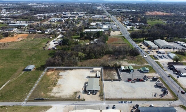
Property Record
783 W Morris Ave, Springdale, AR 72764


NEARBY LISTINGS FOR SALE OR LEASE
Property Detail
783 W Morris Ave
21-00259-000
Springdale
Utilities
ALL OF THE NE 1/4 OF THE NW 1/4 OF THE SW 1/4 OF THE SW 1/4 OF SECTION 24, TOWNSHIP 18 NORTH, RANGE 30 WEST, BENTON COUNTY, ARKANSAS, BEING MORE PARTICULARLY DESCRIBED AS FOLLOWS: COMMENCING AT THE NORTHWEST CORNER OF THE SW 1/4 OF THE SW 1/4 OF SECT
A
Benton
05143C0060G
Arkansas
2025
2.50 AC
2025
Greater Springdale
021408
Fayetteville/Springdale/Rogers
5,720 SF
Fayetteville-Springdale-Rogers, AR-MO
DEMOGRAPHICS near 783 W Morris Ave
1 Mile
3 Mile
5 Mile
2024 Total Population
6,508
48,749
109,809
2029 Population
7,279
53,405
121,342
Pop Growth 2024-2029
+ 11.85%
+ 9.55%
+ 10.50%
Average Age
35
35
35
2024 Total Households
1,882
14,874
35,510
HH Growth 2024-2029
+ 12.01%
+ 9.65%
+ 10.75%
Median Household Inc
$65,711
$62,536
$67,969
Avg Household Size
3.20
3.10
3.00
2024 Avg HH Vehicles
2.00
2.00
2.00
Median Home Value
$222,075
$181,377
$221,082
Median Year Built
1997
1990
1996
Nearby Places
Map Layers
Map Styles
 Street
 Aerial
- Restaurants
- Banks
- Shops
- Fitness
- Groceries
PUBLIC TRANSPORTATION
AIRPORT
Northwest Arkansas Ntl
DRIVE
WALK
Distance
Northwest Arkansas Ntl
30 min
14.9 mi
SALE & LEASE HISTORY
LISTING DATE
SALE/LEASE

Mar 27, 2025
For Sale
Nearby Properties
Address
Land Use
TOTAL SIZE
Lot Size
Zoning
Address
Land Use
TOTAL SIZE
Lot Size
Zoning
367,076 SF
57.31 AC
Address
Land Use
TOTAL SIZE
Lot Size
Zoning
58,764 SF
1.56 AC
Address
Land Use
TOTAL SIZE
Lot Size
Zoning
403,089 SF
1.93 AC
Address
Land Use
TOTAL SIZE
Lot Size
Zoning
153,718 SF
Address
Land Use
TOTAL SIZE
Lot Size
Zoning
341,266 SF
17.61 AC
Address
Land Use
TOTAL SIZE
Lot Size
Zoning
132,494 SF
21.56 AC
Address
Land Use
TOTAL SIZE
Lot Size
Zoning
196,657 SF
18.82 AC
Address
Land Use
TOTAL SIZE
Lot Size
Zoning
191,100 SF
10.03 AC
Address
Land Use
TOTAL SIZE
Lot Size
Zoning
75,610 SF
5.62 AC
Address
Land Use
TOTAL SIZE
Lot Size
Zoning
292,470 SF
17.27 AC
Address
Land Use
TOTAL SIZE
Lot Size
Zoning
174,333 SF
25 AC
I1I2
Address
Land Use
TOTAL SIZE
Lot Size
Zoning
16,698 SF
1.11 AC
Address
Land Use
TOTAL SIZE
Lot Size
Zoning
348,916 SF
24.69 AC
Address
Land Use
TOTAL SIZE
Lot Size
Zoning
117,196 SF
9.74 AC
Address
Land Use
TOTAL SIZE
Lot Size
Zoning
224,408 SF
9.80 AC
I1
Address
Land Use
TOTAL SIZE
Lot Size
Zoning
206,446 SF
17.14 AC
Address
Land Use
TOTAL SIZE
Lot Size
Zoning
12,882 SF
12.33 AC
Address
Land Use
TOTAL SIZE
Lot Size
Zoning
31,150 SF
3.74 AC
C1
Address
Land Use
TOTAL SIZE
Lot Size
Zoning
182,415 SF
68.93 AC
Address
Land Use
TOTAL SIZE
Lot Size
Zoning
182,415 SF
12.04 AC
Address
Land Use
TOTAL SIZE
Lot Size
Zoning
80,475 SF
0.45 AC
C3
Address
Land Use
TOTAL SIZE
Lot Size
Zoning
73,711 SF
3.59 AC
Address
Land Use
TOTAL SIZE
Lot Size
Zoning
61,012 SF
18.96 AC
Address
Land Use
TOTAL SIZE
Lot Size
Zoning
147,762 SF
Address
Land Use
TOTAL SIZE
Lot Size
Zoning
352,195 SF
15 AC
Address
Land Use
TOTAL SIZE
Lot Size
Zoning
54,460 SF
6.38 AC
Address
Land Use
TOTAL SIZE
Lot Size
Zoning
153,968 SF
21 AC
Address
Land Use
TOTAL SIZE
Lot Size
Zoning
364,696 SF
4.49 AC
Address
Land Use
TOTAL SIZE
Lot Size
Zoning
189,244 SF
11.16 AC
I2
Address
Land Use
TOTAL SIZE
Lot Size
Zoning
55,663 SF
2.54 AC
The World's #1 Commercial Real Estate Marketplace
Connect with us
© 2025 CoStar Group
The information above has been obtained from sources believed reliable. While we do not doubt its accuracy we have not verified it and make no guarantee, warranty or representation about it. It is your responsibility to independently confirm its accuracy and completeness. Any projections, opinions, assumptions, or estimates used are for example only and do not represent the current or future performance of the property. The value of this transaction to you depends on tax and other factors which should be evaluated by your tax, financial, and legal advisors. You and your advisors should conduct a careful, independent investigation of the property to determine to your satisfaction the suitability of the property for your needs.