Property Record
7830 Curley Rd, Wesley Chapel, FL 33545


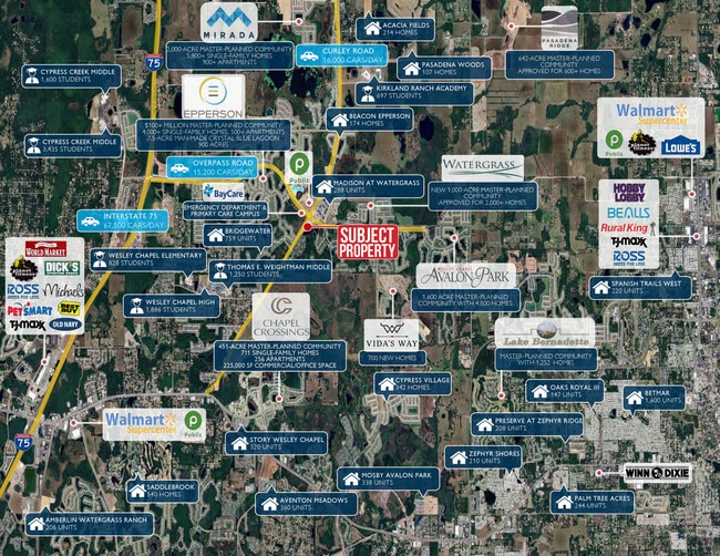
This Property Is For Sale
Current Lease Availabilities
NEARBY LISTINGS FOR SALE OR LEASE
Property Detail
7830 Curley Rd
Tampa-St. Petersburg-Clearwater, FL
Watergrass
35-25-20-0000-49900-0010
THAT PORTION OF WATERGRASS CURLEY RD ADDITIONAL R/W PART I LYING IN SEC 35 DESC AS COM AT SE COR OF SEC 34 TH S89DEG 5846W 2348.96 FT TO ELY R/W LN OF CURLEY RD TH N39DEG 3950E 2797.23 FT TO NWLY COR OF WATERGRASS PCL A & POB TH N39DEG 3950E 18.40 FT
Countyproperty
Pasco
X
Florida
12101C0268F
1
0
0.71 AC
2026
Pasco County
032103
Tampa/St Petersburg
DEMOGRAPHICS near 7830 Curley Rd
1 Mile
3 Mile
5 Mile
2024 Total Population
7,899
30,084
73,864
2029 Population
9,987
37,339
90,536
Pop Growth 2024-2029
+ 26.43%
+ 24.12%
+ 22.57%
Average Age
35
36
40
2024 Total Households
2,532
9,805
26,447
HH Growth 2024-2029
+ 26.38%
+ 24.08%
+ 22.62%
Median Household Inc
$114,712
$99,334
$82,306
Avg Household Size
3.10
3.00
2.70
2024 Avg HH Vehicles
2.00
2.00
2.00
Median Home Value
$303,744
$298,420
$282,775
Median Year Built
2010
2010
2005
Nearby Places
Map Layers
Map Styles
 Street
 Aerial
- Restaurants
- Banks
- Shops
- Fitness
- Groceries
PUBLIC TRANSPORTATION
AIRPORT
Tampa International
DRIVE
WALK
Distance
Tampa International
49 min
35.2 mi
Freight Ports
Port of Tampa Bay
DRIVE
WALK
Distance
Port of Tampa Bay
45 min
30.9 mi
Nearby Properties
Address
Land Use
TOTAL SIZE
Lot Size
Zoning
Address
Land Use
TOTAL SIZE
Lot Size
Zoning
325,024 SF
97.89 AC
AC
Address
Land Use
TOTAL SIZE
Lot Size
Zoning
398,092 SF
22.48 AC
MPUD
Address
Land Use
TOTAL SIZE
Lot Size
Zoning
301,145 SF
17.99 AC
MPUD
Address
Land Use
TOTAL SIZE
Lot Size
Zoning
418,644 SF
105.51 AC
AR
Address
Land Use
TOTAL SIZE
Lot Size
Zoning
287,834 SF
14.40 AC
MPUD
Address
Land Use
TOTAL SIZE
Lot Size
Zoning
241,371 SF
11.48 AC
MPUD
Address
Land Use
TOTAL SIZE
Lot Size
Zoning
157,694 SF
17.50 AC
MPUD
Address
Land Use
TOTAL SIZE
Lot Size
Zoning
142,552 SF
5.69 AC
MPUD
Address
Land Use
TOTAL SIZE
Lot Size
Zoning
109,440 SF
3.28 AC
C2
Address
Land Use
TOTAL SIZE
Lot Size
Zoning
92,475 SF
19.45 AC
MPUD
Address
Land Use
TOTAL SIZE
Lot Size
Zoning
189,610 SF
13.68 AC
MPUD
Address
Land Use
TOTAL SIZE
Lot Size
Zoning
93,933 SF
3.63 AC
C2
Address
Land Use
TOTAL SIZE
Lot Size
Zoning
80,584 SF
22.43 AC
MPUD
Address
Land Use
TOTAL SIZE
Lot Size
Zoning
48,241 SF
7.67 AC
MPUD
Address
Land Use
TOTAL SIZE
Lot Size
Zoning
55,697 SF
7.78 AC
MPUD
Address
Land Use
TOTAL SIZE
Lot Size
Zoning
31,857 SF
3.46 AC
MPUD
Address
Land Use
TOTAL SIZE
Lot Size
Zoning
31,435 SF
133.68 AC
AR
Address
Land Use
TOTAL SIZE
Lot Size
Zoning
14,158 SF
4.78 AC
C2
Address
Land Use
TOTAL SIZE
Lot Size
Zoning
45,757 SF
5.92 AC
MPUD
Address
Land Use
TOTAL SIZE
Lot Size
Zoning
198.90 AC
MPUD
Address
Land Use
TOTAL SIZE
Lot Size
Zoning
25.69 AC
MPUD
Address
Land Use
TOTAL SIZE
Lot Size
Zoning
37,508 SF
10.33 AC
AC
Address
Land Use
TOTAL SIZE
Lot Size
Zoning
13,050 SF
11.18 AC
C1
Address
Land Use
TOTAL SIZE
Lot Size
Zoning
12,088 SF
1.47 AC
MPUD
Address
Land Use
TOTAL SIZE
Lot Size
Zoning
30,939 SF
25.65 AC
AC
Address
Land Use
TOTAL SIZE
Lot Size
Zoning
36,732 SF
20 AC
AR
Address
Land Use
TOTAL SIZE
Lot Size
Zoning
46,183 SF
10.13 AC
AC
Address
Land Use
TOTAL SIZE
Lot Size
Zoning
5,279 SF
1.91 AC
MPUD
Address
Land Use
TOTAL SIZE
Lot Size
Zoning
12,008 SF
2.23 AC
MPUD
The World's #1 Commercial Real Estate Marketplace
Connect with us
© 2026 CoStar Group
The information above has been obtained from sources believed reliable. While we do not doubt its accuracy we have not verified it and make no guarantee, warranty or representation about it. It is your responsibility to independently confirm its accuracy and completeness. Any projections, opinions, assumptions, or estimates used are for example only and do not represent the current or future performance of the property. The value of this transaction to you depends on tax and other factors which should be evaluated by your tax, financial, and legal advisors. You and your advisors should conduct a careful, independent investigation of the property to determine to your satisfaction the suitability of the property for your needs.