Property Record
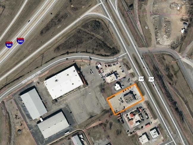
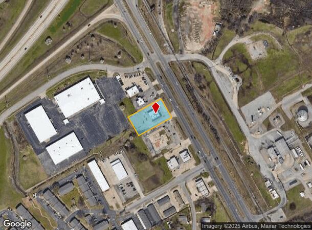
7830 S Highway 71 Hwy S, Fort Smith, AR 72908

NEARBY LISTINGS FOR SALE OR LEASE
Property Detail
7830 S Highway 71 Hwy S
Fort Smith, AR-OK
E-Z-Mart Addition
12397-0003-00000-00
TRACT 3
Storebuilding
Sebastian
X
Arkansas
05131C0120F
3
2025
3.59 AC
2025
Greater Ft Smith
000100
Fort Smith
6,282 SF
DEMOGRAPHICS near 7830 S Highway 71 Hwy S
1 Mile
3 Mile
5 Mile
2024 Total Population
3,843
26,338
64,114
2029 Population
3,885
26,717
65,469
Pop Growth 2024-2029
+ 1.09%
+ 1.44%
+ 2.11%
Average Age
39
40
40
2024 Total Households
1,632
10,957
27,577
HH Growth 2024-2029
+ 1.04%
+ 1.41%
+ 2.14%
Median Household Inc
$41,521
$55,707
$54,573
Avg Household Size
2.30
2.30
2.30
2024 Avg HH Vehicles
2.00
2.00
2.00
Median Home Value
$144,962
$163,340
$176,835
Median Year Built
1982
1982
1979
Nearby Places
Map Layers
Map Styles
 Street
 Aerial
- Restaurants
- Banks
- Shops
- Fitness
- Groceries
PUBLIC TRANSPORTATION
AIRPORT
Fort Smith Regional
DRIVE
WALK
Distance
Fort Smith Regional
12 min
5.1 mi
Freight Ports
Tulsa Port of Inola
DRIVE
WALK
Distance
Tulsa Port of Inola
139 min
110.8 mi
SALE & LEASE HISTORY
LISTING DATE
SALE/LEASE

Oct 26, 2022
For Lease
Jan 25, 2021
For Lease
Aug 07, 2019
For Sale
Nearby Properties
Address
Land Use
TOTAL SIZE
Lot Size
Zoning
Address
Land Use
TOTAL SIZE
Lot Size
Zoning
276,870 SF
36.85 AC
Address
Land Use
TOTAL SIZE
Lot Size
Zoning
364,749 SF
32.41 AC
Address
Land Use
TOTAL SIZE
Lot Size
Zoning
208,886 SF
212.42 AC
Address
Land Use
TOTAL SIZE
Lot Size
Zoning
342,092 SF
12.15 AC
Address
Land Use
TOTAL SIZE
Lot Size
Zoning
847,154 SF
66.34 AC
Address
Land Use
TOTAL SIZE
Lot Size
Zoning
21,556 SF
47 AC
Address
Land Use
TOTAL SIZE
Lot Size
Zoning
198,302 SF
42.39 AC
Address
Land Use
TOTAL SIZE
Lot Size
Zoning
1,174,056 SF
90.54 AC
Address
Land Use
TOTAL SIZE
Lot Size
Zoning
3,675 SF
21.98 AC
Address
Land Use
TOTAL SIZE
Lot Size
Zoning
13,911 SF
25.40 AC
Address
Land Use
TOTAL SIZE
Lot Size
Zoning
275,083 SF
11.29 AC
Address
Land Use
TOTAL SIZE
Lot Size
Zoning
1,350 SF
5.07 AC
C1
Address
Land Use
TOTAL SIZE
Lot Size
Zoning
356,451 SF
44.13 AC
Address
Land Use
TOTAL SIZE
Lot Size
Zoning
242,000 SF
10.62 AC
Address
Land Use
TOTAL SIZE
Lot Size
Zoning
237,553 SF
15.38 AC
Address
Land Use
TOTAL SIZE
Lot Size
Zoning
89,157 SF
15.84 AC
Address
Land Use
TOTAL SIZE
Lot Size
Zoning
613,600 SF
54.46 AC
Address
Land Use
TOTAL SIZE
Lot Size
Zoning
419,250 SF
22.86 AC
Address
Land Use
TOTAL SIZE
Lot Size
Zoning
125,968 SF
9.46 AC
Address
Land Use
TOTAL SIZE
Lot Size
Zoning
418,608 SF
27.04 AC
Address
Land Use
TOTAL SIZE
Lot Size
Zoning
108,519 SF
13.38 AC
Address
Land Use
TOTAL SIZE
Lot Size
Zoning
54,697 SF
7.87 AC
Address
Land Use
TOTAL SIZE
Lot Size
Zoning
18,492 SF
2.03 AC
Address
Land Use
TOTAL SIZE
Lot Size
Zoning
29,522 SF
25 AC
Address
Land Use
TOTAL SIZE
Lot Size
Zoning
539,722 SF
41.86 AC
Address
Land Use
TOTAL SIZE
Lot Size
Zoning
61,881 SF
8.89 AC
Address
Land Use
TOTAL SIZE
Lot Size
Zoning
74,434 SF
8.63 AC
Address
Land Use
TOTAL SIZE
Lot Size
Zoning
238,911 SF
23.57 AC
Address
Land Use
TOTAL SIZE
Lot Size
Zoning
108,000 SF
16.12 AC
Address
Land Use
TOTAL SIZE
Lot Size
Zoning
147,360 SF
20.71 AC
The World's #1 Commercial Real Estate Marketplace
Connect with us
© 2025 CoStar Group
The information above has been obtained from sources believed reliable. While we do not doubt its accuracy we have not verified it and make no guarantee, warranty or representation about it. It is your responsibility to independently confirm its accuracy and completeness. Any projections, opinions, assumptions, or estimates used are for example only and do not represent the current or future performance of the property. The value of this transaction to you depends on tax and other factors which should be evaluated by your tax, financial, and legal advisors. You and your advisors should conduct a careful, independent investigation of the property to determine to your satisfaction the suitability of the property for your needs.