Property Record
784 Route 63, Westmoreland, NH 03467
NEARBY LISTINGS FOR SALE OR LEASE
-
-
View all Westmoreland listings for sale on LoopNet.com
Property Detail
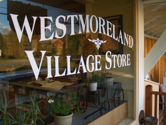
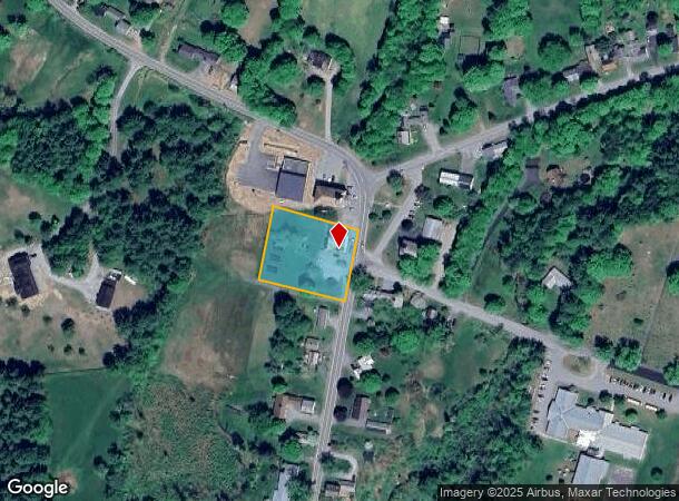
784 Route 63
Commercialbuilding
Cheshire
X
New Hampshire
33005C0229E
1 AC
2024
Manchester/New Hampshire South Area
2024
Other Market Areas
971500
Keene, NH
3,353 SF
WMLD-000007U-000015
DEMOGRAPHICS near 784 Route 63
1 Mile
3 Mile
5 Mile
2024 Total Population
264
1,298
10,462
2029 Population
265
1,301
10,617
Pop Growth 2024-2029
+ 0.38%
+ 0.23%
+ 1.48%
Average Age
50
48
46
2024 Total Households
102
516
4,220
HH Growth 2024-2029
+ 0.98%
+ 0.39%
+ 1.64%
Median Household Inc
$106,250
$104,356
$98,185
Avg Household Size
2.40
2.40
2.30
2024 Avg HH Vehicles
2.00
2.00
2.00
Median Home Value
$387,499
$377,350
$316,780
Median Year Built
1970
1970
1975
Nearby Places
- Restaurants
- Banks
- Shops
- Fitness
- Groceries
Nearby Properties
Address
Land Use
TOTAL SIZE
Lot Size
Zoning
Address
Land Use
TOTAL SIZE
Lot Size
Zoning
63,444 SF
12 AC
RR R
Address
Land Use
TOTAL SIZE
Lot Size
Zoning
26,523 SF
18.30 AC
CV V
Address
Land Use
TOTAL SIZE
Lot Size
Zoning
7,478 SF
2.01 AC
CV V
Address
Land Use
TOTAL SIZE
Lot Size
Zoning
960 SF
RR R
Address
Land Use
TOTAL SIZE
Lot Size
Zoning
1,684 SF
353 AC
RR R
Address
Land Use
TOTAL SIZE
Lot Size
Zoning
6,648 SF
56 AC
RURAL/
Address
Land Use
TOTAL SIZE
Lot Size
Zoning
Address
Land Use
TOTAL SIZE
Lot Size
Zoning
1,909 SF
2.76 AC
RESIDE
Address
Land Use
TOTAL SIZE
Lot Size
Zoning
2,415 SF
45.50 AC
RR R
Address
Land Use
TOTAL SIZE
Lot Size
Zoning
422 SF
1.18 AC
RESIDE
Address
Land Use
TOTAL SIZE
Lot Size
Zoning
2,714 SF
0.40 AC
CV V
Address
Land Use
TOTAL SIZE
Lot Size
Zoning
1,604 SF
0.31 AC
RESIDE
Address
Land Use
TOTAL SIZE
Lot Size
Zoning
3,520 SF
13 AC
MDR M
Address
Land Use
TOTAL SIZE
Lot Size
Zoning
2,544 SF
7.94 AC
RESIDE
Address
Land Use
TOTAL SIZE
Lot Size
Zoning
6,369 SF
0.53 AC
MDR M
Address
Land Use
TOTAL SIZE
Lot Size
Zoning
139.60 AC
Address
Land Use
TOTAL SIZE
Lot Size
Zoning
Address
Land Use
TOTAL SIZE
Lot Size
Zoning
955 SF
545.93 AC
MDR M
Address
Land Use
TOTAL SIZE
Lot Size
Zoning
3,649 SF
109.90 AC
RR R
Address
Land Use
TOTAL SIZE
Lot Size
Zoning
2,483 SF
5.04 AC
RR R
Address
Land Use
TOTAL SIZE
Lot Size
Zoning
1 AC
FR F
Address
Land Use
TOTAL SIZE
Lot Size
Zoning
4,138 SF
11 AC
RR R
Address
Land Use
TOTAL SIZE
Lot Size
Zoning
3,881 SF
4 AC
CV V
Address
Land Use
TOTAL SIZE
Lot Size
Zoning
1,540 SF
16 AC
C/I C
Address
Land Use
TOTAL SIZE
Lot Size
Zoning
3,011 SF
26.30 AC
MDR M
Address
Land Use
TOTAL SIZE
Lot Size
Zoning
2,926 SF
2.31 AC
RIC R
Address
Land Use
TOTAL SIZE
Lot Size
Zoning
2,648 SF
15 AC
MDR M
Address
Land Use
TOTAL SIZE
Lot Size
Zoning
1,907 SF
242.50 AC
RR R
Address
Land Use
TOTAL SIZE
Lot Size
Zoning
3,401 SF
4.50 AC
CV V
The World's #1 Commercial Real Estate Marketplace
Connect with us
© 2025 CoStar Group
The information above has been obtained from sources believed reliable. While we do not doubt its accuracy we have not verified it and make no guarantee, warranty or representation about it. It is your responsibility to independently confirm its accuracy and completeness. Any projections, opinions, assumptions, or estimates used are for example only and do not represent the current or future performance of the property. The value of this transaction to you depends on tax and other factors which should be evaluated by your tax, financial, and legal advisors. You and your advisors should conduct a careful, independent investigation of the property to determine to your satisfaction the suitability of the property for your needs.