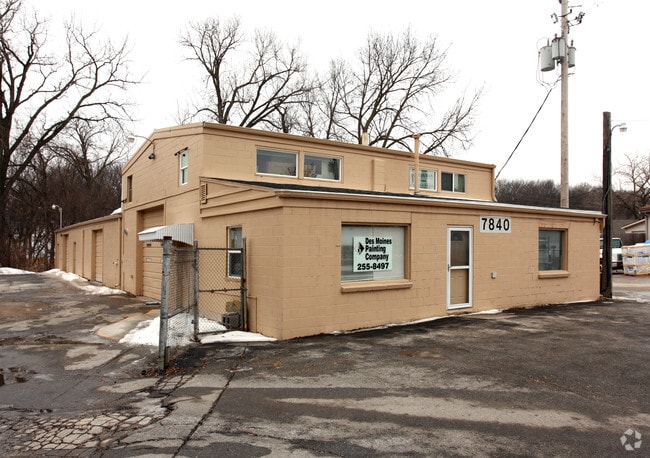
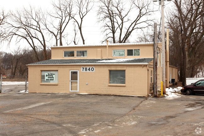
Property Record
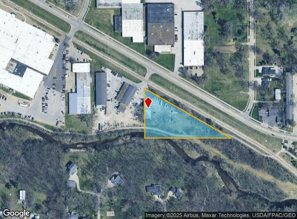
7840 University Blvd, Clive, IA 50325
NEARBY LISTINGS FOR SALE OR LEASE
Property Detail
7840 University Blvd
291-00047000000
Sec 35-79-25
Warehouse
SW 1/4 SE 1/4 S OF RY SEC 35-79-25
AE
Polk
19153C0326F
Iowa
2024
1.77 AC
2025
Western Suburbs
011205
Des Moines
4,640 SF
Des Moines-West Des Moines, IA
DEMOGRAPHICS near 7840 University Blvd
1 Mile
3 Mile
5 Mile
2024 Total Population
9,804
85,231
193,734
2029 Population
10,112
87,833
202,779
Pop Growth 2024-2029
+ 3.14%
+ 3.05%
+ 4.67%
Average Age
39
40
39
2024 Total Households
4,336
37,201
82,607
HH Growth 2024-2029
+ 3.51%
+ 3.27%
+ 4.98%
Median Household Inc
$57,856
$73,525
$72,832
Avg Household Size
2.20
2.20
2.30
2024 Avg HH Vehicles
2.00
2.00
2.00
Median Home Value
$242,008
$227,471
$238,854
Median Year Built
1971
1970
1976
Nearby Places
Map Layers
Map Styles
 Street
 Aerial
- Restaurants
- Banks
- Shops
- Fitness
- Groceries
PUBLIC TRANSPORTATION
AIRPORT
Des Moines International
DRIVE
WALK
Distance
Des Moines International
15 min
7.4 mi
Freight Ports
Port Milwaukee
DRIVE
WALK
Distance
Port Milwaukee
423 min
379.5 mi
SALE & LEASE HISTORY
LISTING DATE
SALE/LEASE

Jul 16, 2020
For Lease
Nearby Properties
Address
Land Use
TOTAL SIZE
Lot Size
Zoning
Address
Land Use
TOTAL SIZE
Lot Size
Zoning
255,521 SF
60.90 AC
RE
Address
Land Use
TOTAL SIZE
Lot Size
Zoning
422,683 SF
46.57 AC
PCP
Address
Land Use
TOTAL SIZE
Lot Size
Zoning
407,183 SF
17.02 AC
PUD
Address
Land Use
TOTAL SIZE
Lot Size
Zoning
415,320 SF
51.16 AC
PUD
Address
Land Use
TOTAL SIZE
Lot Size
Zoning
241,324 SF
21.67 AC
PUD B&C
Address
Land Use
TOTAL SIZE
Lot Size
Zoning
322,220 SF
7.61 AC
Address
Land Use
TOTAL SIZE
Lot Size
Zoning
572,809 SF
42.13 AC
M-2
Address
Land Use
TOTAL SIZE
Lot Size
Zoning
341,024 SF
12.15 AC
RH
Address
Land Use
TOTAL SIZE
Lot Size
Zoning
67,691 SF
7.30 AC
Address
Land Use
TOTAL SIZE
Lot Size
Zoning
444,073 SF
28.05 AC
RH
Address
Land Use
TOTAL SIZE
Lot Size
Zoning
151,344 SF
10.43 AC
C-3
Address
Land Use
TOTAL SIZE
Lot Size
Zoning
195,931 SF
13.66 AC
Address
Land Use
TOTAL SIZE
Lot Size
Zoning
221,654 SF
26.38 AC
PUD MD
Address
Land Use
TOTAL SIZE
Lot Size
Zoning
308,117 SF
18.33 AC
RH
Address
Land Use
TOTAL SIZE
Lot Size
Zoning
80,045 SF
5.07 AC
C-3
Address
Land Use
TOTAL SIZE
Lot Size
Zoning
150,640 SF
2.46 AC
PUD
Address
Land Use
TOTAL SIZE
Lot Size
Zoning
235,620 SF
13.18 AC
RH
Address
Land Use
TOTAL SIZE
Lot Size
Zoning
1,164,314 SF
57.72 AC
RC
Address
Land Use
TOTAL SIZE
Lot Size
Zoning
386,236 SF
9.62 AC
C-4
Address
Land Use
TOTAL SIZE
Lot Size
Zoning
117,272 SF
3.46 AC
R1-60
Address
Land Use
TOTAL SIZE
Lot Size
Zoning
175,810 SF
19.36 AC
RC
Address
Land Use
TOTAL SIZE
Lot Size
Zoning
247,414 SF
15.83 AC
RH
Address
Land Use
TOTAL SIZE
Lot Size
Zoning
192,222 SF
9.27 AC
Address
Land Use
TOTAL SIZE
Lot Size
Zoning
189,506 SF
11.78 AC
PUD HD
Address
Land Use
TOTAL SIZE
Lot Size
Zoning
166,908 SF
8.03 AC
R-3
Address
Land Use
TOTAL SIZE
Lot Size
Zoning
168,556 SF
10.92 AC
RH
Address
Land Use
TOTAL SIZE
Lot Size
Zoning
125,396 SF
12.89 AC
PUD
Address
Land Use
TOTAL SIZE
Lot Size
Zoning
101,280 SF
15.69 AC
PCP
Address
Land Use
TOTAL SIZE
Lot Size
Zoning
258,178 SF
5.95 AC
Address
Land Use
TOTAL SIZE
Lot Size
Zoning
88,590 SF
11.22 AC
C-2
The World's #1 Commercial Real Estate Marketplace
Connect with us
© 2026 CoStar Group
The information above has been obtained from sources believed reliable. While we do not doubt its accuracy we have not verified it and make no guarantee, warranty or representation about it. It is your responsibility to independently confirm its accuracy and completeness. Any projections, opinions, assumptions, or estimates used are for example only and do not represent the current or future performance of the property. The value of this transaction to you depends on tax and other factors which should be evaluated by your tax, financial, and legal advisors. You and your advisors should conduct a careful, independent investigation of the property to determine to your satisfaction the suitability of the property for your needs.