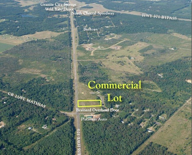
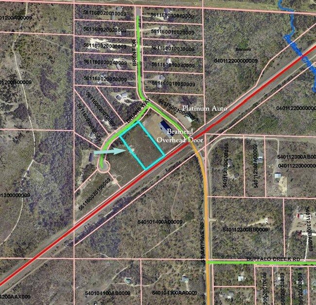
Property Record
7845 Brians Way, Brainerd, MN 56401

Property Detail
7845 Brians Way
Brainerd, MN
LOT 12 BLOCK 2
561160020120009
CROW WING
Industrialgeneral
Minnesota
B and X Area of moderate flood hazard, usually the area between the limits of the 100-year and 500-year floods.
12
2026
2.32 AC
2025
Minnesota Central Area
951400
Other Market Areas
6,000 SF
NEARBY LISTINGS FOR SALE OR LEASE
DEMOGRAPHICS near 7845 Brians Way
1 mile
3 mile
5 mile
2025 Total Population
314
7,260
21,832
2030 Population
307
7,156
21,458
Pop Growth 2025-2030
(2.23%)
(1.43%)
(1.71%)
Average Age
39
41
40
2025 Total Households
116
2,943
8,857
HH Growth 2025-2030
(2.59%)
(1.53%)
(1.87%)
Median Household Inc
$98,213
$73,749
$62,954
Avg Household Size
2.60
2.30
2.30
2025 Avg HH Vehicles
3.00
2.00
2.00
Median Home Value
$320,270
$273,548
$266,546
Median Year Built
1999
1986
1983
Nearby Places
Map Layers
Map Styles
 Street
 Aerial
Layers
 Traffic
 Biking
Places
Listings with unknown addresses are not visible on the map
- Restaurants
- Banks
- Shops
- Fitness
- Groceries
Nearby Properties
Address
Land Use
TOTAL SIZE
Lot Size
Zoning
Address
Land Use
TOTAL SIZE
Lot Size
Zoning
320,708 SF
35.89 AC
Address
Land Use
TOTAL SIZE
Lot Size
Zoning
344,274 SF
163.56 AC
Address
Land Use
TOTAL SIZE
Lot Size
Zoning
110,624 SF
5.62 AC
Address
Land Use
TOTAL SIZE
Lot Size
Zoning
33,460 SF
94.30 AC
Address
Land Use
TOTAL SIZE
Lot Size
Zoning
91,464 SF
4.83 AC
Address
Land Use
TOTAL SIZE
Lot Size
Zoning
63,251 SF
8.27 AC
Address
Land Use
TOTAL SIZE
Lot Size
Zoning
50,741 SF
13.48 AC
Address
Land Use
TOTAL SIZE
Lot Size
Zoning
55,953 SF
14.52 AC
Address
Land Use
TOTAL SIZE
Lot Size
Zoning
69,515 SF
2.14 AC
Address
Land Use
TOTAL SIZE
Lot Size
Zoning
68,675 SF
3.12 AC
Address
Land Use
TOTAL SIZE
Lot Size
Zoning
68,675 SF
3.06 AC
Address
Land Use
TOTAL SIZE
Lot Size
Zoning
209,815 SF
22.30 AC
Address
Land Use
TOTAL SIZE
Lot Size
Zoning
87,007 SF
4.98 AC
Address
Land Use
TOTAL SIZE
Lot Size
Zoning
79,048 SF
5.33 AC
Address
Land Use
TOTAL SIZE
Lot Size
Zoning
30,819 SF
9.36 AC
Address
Land Use
TOTAL SIZE
Lot Size
Zoning
50,344 SF
12.62 AC
Address
Land Use
TOTAL SIZE
Lot Size
Zoning
89,709 SF
8.69 AC
Address
Land Use
TOTAL SIZE
Lot Size
Zoning
21,876 SF
9.73 AC
Address
Land Use
TOTAL SIZE
Lot Size
Zoning
64,719 SF
2.06 AC
Address
Land Use
TOTAL SIZE
Lot Size
Zoning
64,719 SF
2.19 AC
Address
Land Use
TOTAL SIZE
Lot Size
Zoning
17,516 SF
3.46 AC
Address
Land Use
TOTAL SIZE
Lot Size
Zoning
147,000 SF
41.18 AC
Address
Land Use
TOTAL SIZE
Lot Size
Zoning
91,681 SF
6.65 AC
Address
Land Use
TOTAL SIZE
Lot Size
Zoning
15,105 SF
45.02 AC
Address
Land Use
TOTAL SIZE
Lot Size
Zoning
16,392 SF
26.78 AC
Address
Land Use
TOTAL SIZE
Lot Size
Zoning
32,540 SF
6.65 AC
Address
Land Use
TOTAL SIZE
Lot Size
Zoning
37,996 SF
6.32 AC
Address
Land Use
TOTAL SIZE
Lot Size
Zoning
125,156 SF
13.35 AC
Address
Land Use
TOTAL SIZE
Lot Size
Zoning
29,100 SF
2.35 AC
Address
Land Use
TOTAL SIZE
Lot Size
Zoning
40,728 SF
3.09 AC
The World's #1 Commercial Real Estate Marketplace
Connect with us
© 2026 CoStar Group
The information above has been obtained from sources believed reliable. While we do not doubt its accuracy we have not verified it and make no guarantee, warranty or representation about it. It is your responsibility to independently confirm its accuracy and completeness. Any projections, opinions, assumptions, or estimates used are for example only and do not represent the current or future performance of the property. The value of this transaction to you depends on tax and other factors which should be evaluated by your tax, financial, and legal advisors. You and your advisors should conduct a careful, independent investigation of the property to determine to your satisfaction the suitability of the property for your needs.