Property Record
7846 Sw Highway 200, Ocala, FL 34476


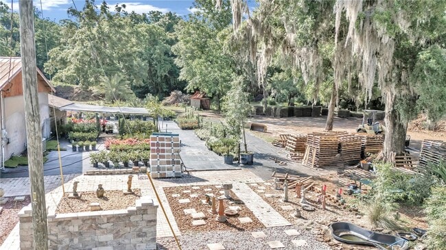
This Property Is For Sale
NEARBY LISTINGS FOR SALE OR LEASE
Property Detail
7846 Sw Highway 200
35695-019-00
SEC 19 TWP 16 RGE 21 COM AT THE SE COR OF NW 1/4 TH N 89-54-56 W 1393.38 FT TH CONT N 89-54-56 W 360.84 FT TO THE POB TH CONT N 89-54-56 W 81.53 FT TH S 35-53-23 W 158 FT TO PT BEING ON CURVE HAVING A RADIUS OF 266 FT A CENTRAL ANGLE OF 48-25-45 & A
Commercialnec
Marion
X
Florida
12083C0703E
44
2025
1.82 AC
2025
Outlying Marion County
001010
Ocala
4,990 SF
Ocala, FL
DEMOGRAPHICS near 7846 Sw Highway 200
1 Mile
3 Mile
5 Mile
2024 Total Population
4,702
39,764
64,315
2029 Population
6,003
51,008
82,542
Pop Growth 2024-2029
+ 27.67%
+ 28.28%
+ 28.34%
Average Age
66
62
55
2024 Total Households
2,600
20,519
30,553
HH Growth 2024-2029
+ 28.15%
+ 28.68%
+ 28.73%
Median Household Inc
$51,654
$59,583
$62,428
Avg Household Size
1.70
1.90
2.10
2024 Avg HH Vehicles
1.00
1.00
2.00
Median Home Value
$219,816
$288,670
$295,296
Median Year Built
1993
1997
2000
Nearby Places
Map Layers
Map Styles
 Street
 Aerial
- Restaurants
- Banks
- Shops
- Fitness
- Groceries
Nearby Properties
Address
Land Use
TOTAL SIZE
Lot Size
Zoning
Address
Land Use
TOTAL SIZE
Lot Size
Zoning
380,749 SF
40.05 AC
PUD
Address
Land Use
TOTAL SIZE
Lot Size
Zoning
304,259 SF
31.62 AC
PUD
Address
Land Use
TOTAL SIZE
Lot Size
Zoning
96,094 SF
13.66 AC
B2
Address
Land Use
TOTAL SIZE
Lot Size
Zoning
62,253 SF
6.52 AC
PUD
Address
Land Use
TOTAL SIZE
Lot Size
Zoning
103,410 SF
27.04 AC
PUD
Address
Land Use
TOTAL SIZE
Lot Size
Zoning
74,928 SF
7.80 AC
PUD
Address
Land Use
TOTAL SIZE
Lot Size
Zoning
210,937 SF
27.08 AC
B4
Address
Land Use
TOTAL SIZE
Lot Size
Zoning
28,813 SF
70.30 AC
B4
Address
Land Use
TOTAL SIZE
Lot Size
Zoning
18,035 SF
3.33 AC
B2
Address
Land Use
TOTAL SIZE
Lot Size
Zoning
43,619 SF
6.04 AC
R3
Address
Land Use
TOTAL SIZE
Lot Size
Zoning
139,728 SF
22.86 AC
B4
Address
Land Use
TOTAL SIZE
Lot Size
Zoning
101,312 SF
5,201.15 AC
A1
Address
Land Use
TOTAL SIZE
Lot Size
Zoning
65,060 SF
11.90 AC
B2
Address
Land Use
TOTAL SIZE
Lot Size
Zoning
98,205 SF
13.41 AC
B2
Address
Land Use
TOTAL SIZE
Lot Size
Zoning
77,877 SF
13.38 AC
B2
Address
Land Use
TOTAL SIZE
Lot Size
Zoning
88,777 SF
10.50 AC
B4
Address
Land Use
TOTAL SIZE
Lot Size
Zoning
69,278 SF
7.52 AC
B4
Address
Land Use
TOTAL SIZE
Lot Size
Zoning
42,673 SF
13.72 AC
A1
Address
Land Use
TOTAL SIZE
Lot Size
Zoning
42,159 SF
5.95 AC
B2
Address
Land Use
TOTAL SIZE
Lot Size
Zoning
68,180 SF
5.40 AC
B5
Address
Land Use
TOTAL SIZE
Lot Size
Zoning
82,465 SF
6.13 AC
B2
Address
Land Use
TOTAL SIZE
Lot Size
Zoning
82,904 SF
10.51 AC
B2
Address
Land Use
TOTAL SIZE
Lot Size
Zoning
16,729 SF
5 AC
B4
Address
Land Use
TOTAL SIZE
Lot Size
Zoning
27,563 SF
3.03 AC
B4
Address
Land Use
TOTAL SIZE
Lot Size
Zoning
47,378 SF
23.26 AC
A1
Address
Land Use
TOTAL SIZE
Lot Size
Zoning
286.80 AC
PUD
Address
Land Use
TOTAL SIZE
Lot Size
Zoning
58,381 SF
5.12 AC
R3
Address
Land Use
TOTAL SIZE
Lot Size
Zoning
16,214 SF
4.91 AC
B2
Address
Land Use
TOTAL SIZE
Lot Size
Zoning
38,062 SF
3.07 AC
B2
Address
Land Use
TOTAL SIZE
Lot Size
Zoning
37,213 SF
14.54 AC
A1
The World's #1 Commercial Real Estate Marketplace
Connect with us
© 2025 CoStar Group
The information above has been obtained from sources believed reliable. While we do not doubt its accuracy we have not verified it and make no guarantee, warranty or representation about it. It is your responsibility to independently confirm its accuracy and completeness. Any projections, opinions, assumptions, or estimates used are for example only and do not represent the current or future performance of the property. The value of this transaction to you depends on tax and other factors which should be evaluated by your tax, financial, and legal advisors. You and your advisors should conduct a careful, independent investigation of the property to determine to your satisfaction the suitability of the property for your needs.