Property Record
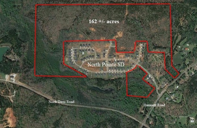
785 Hammett Rd, Lagrange, GA 30241


Property Detail
785 Hammett Rd
049-1-000-003
HAMMETT RD/PB15-PG83/TR-2 PB70 PG210/211
Residentialacreage
Troup
16- SU-R
Georgia
AE The base floodplain where base flood elevations are provided. AE Zones are now used on new format FIRMs instead of A1-A30 Zones.
142.16 AC
2025
Troup County
2025
Columbus GA
960600
LaGrange, GA-AL
NEARBY LISTINGS FOR SALE OR LEASE
DEMOGRAPHICS near 785 Hammett Rd
1 mile
3 mile
5 mile
2025 Total Population
592
16,681
35,879
2030 Population
604
17,116
37,168
Pop Growth 2025-2030
+ 2.03%
+ 2.61%
+ 3.59%
Average Age
39
38
39
2025 Total Households
236
6,656
14,007
HH Growth 2025-2030
+ 1.69%
+ 2.70%
+ 3.76%
Median Household Inc
$74,374
$52,430
$49,999
Avg Household Size
2.50
2.50
2.50
2025 Avg HH Vehicles
2.00
2.00
2.00
Median Home Value
$237,209
$248,079
$231,794
Median Year Built
1987
1987
1983
Nearby Places
Map Layers
Map Styles
 Street
 Aerial
Layers
 Traffic
 Biking
Places
Listings with unknown addresses are not visible on the map
- Restaurants
- Banks
- Shops
- Fitness
- Groceries
SALE & LEASE HISTORY
LISTING DATE
SALE/LEASE

Oct 02, 2017
For Sale
Nearby Properties
Address
Land Use
TOTAL SIZE
Lot Size
Zoning
Address
Land Use
TOTAL SIZE
Lot Size
Zoning
117,684 SF
12.61 AC
16- AC-MX
Address
Land Use
TOTAL SIZE
Lot Size
Zoning
191,357 SF
89.77 AC
01-SU-R
Address
Land Use
TOTAL SIZE
Lot Size
Zoning
2,152 SF
21.70 AC
16- CR-MR
Address
Land Use
TOTAL SIZE
Lot Size
Zoning
141,328 SF
7.18 AC
16- TN-MX
Address
Land Use
TOTAL SIZE
Lot Size
Zoning
121,889 SF
8.99 AC
16- CR-MX
Address
Land Use
TOTAL SIZE
Lot Size
Zoning
3,798 SF
22.81 AC
16- CR-MR
Address
Land Use
TOTAL SIZE
Lot Size
Zoning
138,573 SF
59.91 AC
01-SU-R
Address
Land Use
TOTAL SIZE
Lot Size
Zoning
8,448 SF
25.78 AC
16- CR-MX
Address
Land Use
TOTAL SIZE
Lot Size
Zoning
56,620 SF
5.22 AC
16- CR-MX
Address
Land Use
TOTAL SIZE
Lot Size
Zoning
22,600 SF
15.57 AC
16- CR-MX
Address
Land Use
TOTAL SIZE
Lot Size
Zoning
3,433 SF
19.65 AC
16- CR-MR
Address
Land Use
TOTAL SIZE
Lot Size
Zoning
8,752 SF
13.43 AC
16- CR-MR
Address
Land Use
TOTAL SIZE
Lot Size
Zoning
92,762 SF
61.32 AC
01-SU-R
Address
Land Use
TOTAL SIZE
Lot Size
Zoning
26,150 SF
3.28 AC
16- CR-MX
Address
Land Use
TOTAL SIZE
Lot Size
Zoning
92,762 SF
78.28 AC
16- SU-R
Address
Land Use
TOTAL SIZE
Lot Size
Zoning
112,950 SF
15.47 AC
16- CR-MX
Address
Land Use
TOTAL SIZE
Lot Size
Zoning
8,424 SF
11 AC
16- CR-MR
Address
Land Use
TOTAL SIZE
Lot Size
Zoning
218,488 SF
32.40 AC
16- CR-MX
Address
Land Use
TOTAL SIZE
Lot Size
Zoning
34,380 SF
59.74 AC
16- CR-MX
Address
Land Use
TOTAL SIZE
Lot Size
Zoning
125,467 SF
35.19 AC
16- CR-MX
Address
Land Use
TOTAL SIZE
Lot Size
Zoning
16,916 SF
15.33 AC
16- SU-R
Address
Land Use
TOTAL SIZE
Lot Size
Zoning
35,512 SF
2.64 AC
16- CR-MX
Address
Land Use
TOTAL SIZE
Lot Size
Zoning
7,780 SF
9.65 AC
16- CR-MR
Address
Land Use
TOTAL SIZE
Lot Size
Zoning
33,598 SF
3.78 AC
16- CR-MX
Address
Land Use
TOTAL SIZE
Lot Size
Zoning
52,148 SF
7.33 AC
16- CR-MX
Address
Land Use
TOTAL SIZE
Lot Size
Zoning
7,500 SF
7.84 AC
16- CR-MX
Address
Land Use
TOTAL SIZE
Lot Size
Zoning
82,611 SF
6.24 AC
16- CR-MX
Address
Land Use
TOTAL SIZE
Lot Size
Zoning
63,095 SF
6.27 AC
16- CR-MX
Address
Land Use
TOTAL SIZE
Lot Size
Zoning
38,436 SF
3.59 AC
16- CR-MR
Address
Land Use
TOTAL SIZE
Lot Size
Zoning
17,572 SF
2.10 AC
01-HC
The World's #1 Commercial Real Estate Marketplace
Connect with us
© 2026 CoStar Group
The information above has been obtained from sources believed reliable. While we do not doubt its accuracy we have not verified it and make no guarantee, warranty or representation about it. It is your responsibility to independently confirm its accuracy and completeness. Any projections, opinions, assumptions, or estimates used are for example only and do not represent the current or future performance of the property. The value of this transaction to you depends on tax and other factors which should be evaluated by your tax, financial, and legal advisors. You and your advisors should conduct a careful, independent investigation of the property to determine to your satisfaction the suitability of the property for your needs.