Property Record
785 Highway 29 Dr N, Athens, GA 30601

NEARBY LISTINGS FOR SALE OR LEASE
Property Detail
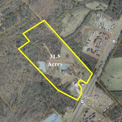
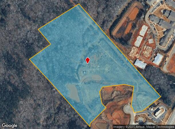
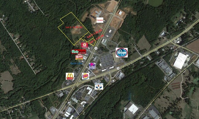
785 Highway 29 Dr N
Athens-Clarke County, GA
Com-St-048->10-15
154-036
LOT 3B - BLK B - 23.449 AC - PB I/278
Residentialacreage
Clarke
AE
Georgia
13059C0017F
3b
2025
23.14 AC
2025
North Athens
140400
Other Market Areas
2,058 SF
DEMOGRAPHICS near 785 Highway 29 Dr N
1 Mile
3 Mile
5 Mile
2024 Total Population
1,094
20,348
74,221
2029 Population
1,128
20,559
75,327
Pop Growth 2024-2029
+ 3.11%
+ 1.04%
+ 1.49%
Average Age
39
35
33
2024 Total Households
408
7,825
27,618
HH Growth 2024-2029
+ 3.43%
+ 0.79%
+ 1.44%
Median Household Inc
$57,646
$40,089
$43,753
Avg Household Size
2.60
2.50
2.30
2024 Avg HH Vehicles
2.00
2.00
2.00
Median Home Value
$93,705
$140,060
$197,021
Median Year Built
1995
1991
1984
Nearby Places
- Restaurants
- Banks
- Shops
- Fitness
- Groceries
SALE & LEASE HISTORY
LISTING DATE
SALE/LEASE

Sep 24, 2016
For Sale
Jul 16, 2021
For Sale
Nearby Properties
Address
Land Use
TOTAL SIZE
Lot Size
Zoning
Address
Land Use
TOTAL SIZE
Lot Size
Zoning
1,403 SF
21.64 AC
C-G
Address
Land Use
TOTAL SIZE
Lot Size
Zoning
3.16 AC
E-I
Address
Land Use
TOTAL SIZE
Lot Size
Zoning
2,856 SF
39.78 AC
C-G
Address
Land Use
TOTAL SIZE
Lot Size
Zoning
8,357 SF
22.38 AC
RM-2
Address
Land Use
TOTAL SIZE
Lot Size
Zoning
124,959 SF
20.54 AC
E-I
Address
Land Use
TOTAL SIZE
Lot Size
Zoning
2,880 SF
36.84 AC
RM-1
Address
Land Use
TOTAL SIZE
Lot Size
Zoning
3,628 SF
6.57 AC
RM-2
Address
Land Use
TOTAL SIZE
Lot Size
Zoning
140,375 SF
26.15 AC
E-I
Address
Land Use
TOTAL SIZE
Lot Size
Zoning
46.26 AC
G
Address
Land Use
TOTAL SIZE
Lot Size
Zoning
Address
Land Use
TOTAL SIZE
Lot Size
Zoning
9,600 SF
12.71 AC
RM-2
Address
Land Use
TOTAL SIZE
Lot Size
Zoning
14,000 SF
42.62 AC
E-I
Address
Land Use
TOTAL SIZE
Lot Size
Zoning
4,392 SF
11.79 AC
C-G
Address
Land Use
TOTAL SIZE
Lot Size
Zoning
26,100 SF
18.59 AC
C-G
Address
Land Use
TOTAL SIZE
Lot Size
Zoning
71,472 SF
43.36 AC
E-I
Address
Land Use
TOTAL SIZE
Lot Size
Zoning
72,072 SF
7.59 AC
RM-2
Address
Land Use
TOTAL SIZE
Lot Size
Zoning
262,387 SF
16.45 AC
E-I
Address
Land Use
TOTAL SIZE
Lot Size
Zoning
47,928 SF
80.47 AC
E-I
Address
Land Use
TOTAL SIZE
Lot Size
Zoning
36.93 AC
G
Address
Land Use
TOTAL SIZE
Lot Size
Zoning
11,520 SF
5.03 AC
RM-2
Address
Land Use
TOTAL SIZE
Lot Size
Zoning
2,465 SF
9.45 AC
RM-2
Address
Land Use
TOTAL SIZE
Lot Size
Zoning
124,136 SF
19.82 AC
C-G (PD)
Address
Land Use
TOTAL SIZE
Lot Size
Zoning
136,460 SF
13.27 AC
C-G
Address
Land Use
TOTAL SIZE
Lot Size
Zoning
18.38 AC
G
Address
Land Use
TOTAL SIZE
Lot Size
Zoning
67,768 SF
40 AC
E-I
Address
Land Use
TOTAL SIZE
Lot Size
Zoning
15.34 AC
G
Address
Land Use
TOTAL SIZE
Lot Size
Zoning
258,200 SF
16.49 AC
E-I
Address
Land Use
TOTAL SIZE
Lot Size
Zoning
16.63 AC
G
Address
Land Use
TOTAL SIZE
Lot Size
Zoning
327,319 SF
24.46 AC
E-I
Address
Land Use
TOTAL SIZE
Lot Size
Zoning
8,664 SF
103.89 AC
E-I
The World's #1 Commercial Real Estate Marketplace
Connect with us
© 2025 CoStar Group
The information above has been obtained from sources believed reliable. While we do not doubt its accuracy we have not verified it and make no guarantee, warranty or representation about it. It is your responsibility to independently confirm its accuracy and completeness. Any projections, opinions, assumptions, or estimates used are for example only and do not represent the current or future performance of the property. The value of this transaction to you depends on tax and other factors which should be evaluated by your tax, financial, and legal advisors. You and your advisors should conduct a careful, independent investigation of the property to determine to your satisfaction the suitability of the property for your needs.