Property Record
785 Schellbourne St, Reno, NV 89511

Property Detail
785 Schellbourne St
Reno, NV
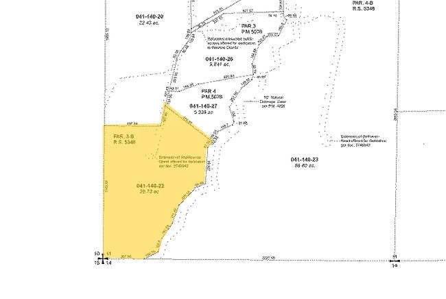
RS 5348 PAR 3-B
041-140-22
WASHOE
Residentialacreage
Nevada
MDR 73% /
3-b
B and X Area of moderate flood hazard, usually the area between the limits of the 100-year and 500-year floods.
20.73 AC
2025
South Meadows
2026
Reno/Sparks
001013
NEARBY LISTINGS FOR SALE OR LEASE
DEMOGRAPHICS near 785 Schellbourne St
1 mile
3 mile
5 mile
2025 Total Population
676
15,966
94,409
2030 Population
694
16,331
97,017
Pop Growth 2025-2030
+ 2.66%
+ 2.29%
+ 2.76%
Average Age
51
48
43
2025 Total Households
271
6,718
40,036
HH Growth 2025-2030
+ 2.58%
+ 2.22%
+ 2.82%
Median Household Inc
$175,000
$129,908
$91,433
Avg Household Size
2.50
2.30
2.30
2025 Avg HH Vehicles
3.00
2.00
2.00
Median Home Value
$1,086,441
$968,983
$749,321
Median Year Built
2002
1992
1990
Nearby Places
Map Layers
Map Styles
 Street
 Aerial
Transit
 Traffic
 Biking
Places
Listings with unknown addresses are not visible on the map
- Restaurants
- Banks
- Shops
- Fitness
- Groceries
PUBLIC TRANSPORTATION
COMMUTER RAIL
Reno (California Zephyr - Amtrak)
Drive
Walk
Distance
Reno (California Zephyr - Amtrak)
21 min
7.7 mi
AIRPORT
Reno/Tahoe International
Drive
Walk
Distance
Reno/Tahoe International
35 min
10.1 mi
Freight Ports
Port of Stockton
Drive
Walk
Distance
Port of Stockton
224 min
185.8 mi
Nearby Properties
Address
Land Use
TOTAL SIZE
Lot Size
Zoning
Address
Land Use
TOTAL SIZE
Lot Size
Zoning
421,744 SF
12.07 AC
MS
Address
Land Use
TOTAL SIZE
Lot Size
Zoning
191,762 SF
51.49 AC
LDS
Address
Land Use
TOTAL SIZE
Lot Size
Zoning
342,019 SF
23.32 AC
MF14
Address
Land Use
TOTAL SIZE
Lot Size
Zoning
149,324 SF
4.34 AC
PD
Address
Land Use
TOTAL SIZE
Lot Size
Zoning
252,039 SF
19.54 AC
MF14
Address
Land Use
TOTAL SIZE
Lot Size
Zoning
139,552 SF
10.64 AC
MS
Address
Land Use
TOTAL SIZE
Lot Size
Zoning
299,798 SF
17.77 AC
SF5
Address
Land Use
TOTAL SIZE
Lot Size
Zoning
73,904 SF
4.86 AC
PO
Address
Land Use
TOTAL SIZE
Lot Size
Zoning
248,200 SF
12.50 AC
MS
Address
Land Use
TOTAL SIZE
Lot Size
Zoning
107,028 SF
4.10 AC
PD
Address
Land Use
TOTAL SIZE
Lot Size
Zoning
68,506 SF
11.43 AC
MS
Address
Land Use
TOTAL SIZE
Lot Size
Zoning
175,120 SF
14.92 AC
PD
Address
Land Use
TOTAL SIZE
Lot Size
Zoning
235,500 SF
11.57 AC
MS
Address
Land Use
TOTAL SIZE
Lot Size
Zoning
217,998 SF
14.70 AC
MF30
Address
Land Use
TOTAL SIZE
Lot Size
Zoning
65,075 SF
3.50 AC
SPD
Address
Land Use
TOTAL SIZE
Lot Size
Zoning
142,779 SF
13.05 AC
MS
Address
Land Use
TOTAL SIZE
Lot Size
Zoning
56,594 SF
3.29 AC
SPD
Address
Land Use
TOTAL SIZE
Lot Size
Zoning
20,678 SF
7.64 AC
PD
Address
Land Use
TOTAL SIZE
Lot Size
Zoning
43,925 SF
2.27 AC
SPD
Address
Land Use
TOTAL SIZE
Lot Size
Zoning
24,000 SF
33.42 AC
LDS
Address
Land Use
TOTAL SIZE
Lot Size
Zoning
64,974 SF
3.78 AC
MU
Address
Land Use
TOTAL SIZE
Lot Size
Zoning
74,799 SF
149.07 AC
PR
Address
Land Use
TOTAL SIZE
Lot Size
Zoning
79,381 SF
8.68 AC
MS
Address
Land Use
TOTAL SIZE
Lot Size
Zoning
116,256 SF
7.12 AC
PD
Address
Land Use
TOTAL SIZE
Lot Size
Zoning
158,695 SF
10.93 AC
MF30
Address
Land Use
TOTAL SIZE
Lot Size
Zoning
50,255 SF
6.25 AC
MS
Address
Land Use
TOTAL SIZE
Lot Size
Zoning
60,024 SF
4.38 AC
SPD
Address
Land Use
TOTAL SIZE
Lot Size
Zoning
59,974 SF
7.91 AC
MS
Address
Land Use
TOTAL SIZE
Lot Size
Zoning
76,745 SF
6.89 AC
MS
Address
Land Use
TOTAL SIZE
Lot Size
Zoning
102,832 SF
9.99 AC
MS
The World's #1 Commercial Real Estate Marketplace
Connect with us
© 2026 CoStar Group
The information above has been obtained from sources believed reliable. While we do not doubt its accuracy we have not verified it and make no guarantee, warranty or representation about it. It is your responsibility to independently confirm its accuracy and completeness. Any projections, opinions, assumptions, or estimates used are for example only and do not represent the current or future performance of the property. The value of this transaction to you depends on tax and other factors which should be evaluated by your tax, financial, and legal advisors. You and your advisors should conduct a careful, independent investigation of the property to determine to your satisfaction the suitability of the property for your needs.