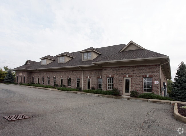
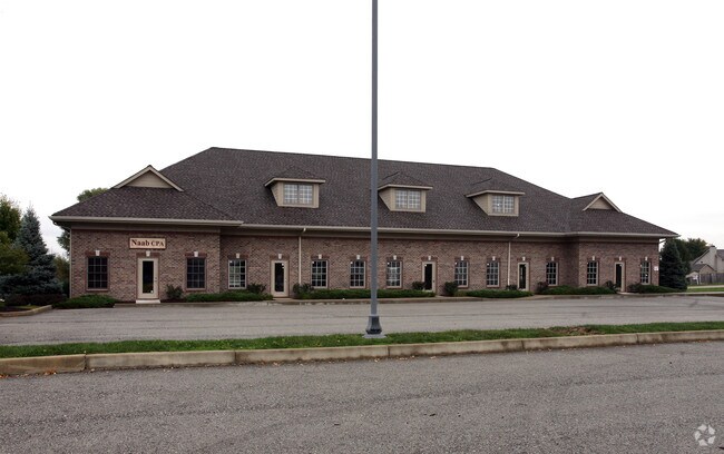
Property Record
7855 Cork Rd, Indianapolis, IN 46236

NEARBY LISTINGS FOR SALE OR LEASE
-
-
View all Indianapolis listings for sale on LoopNet.com
Property Detail
7855 Cork Rd
49-01-28-116-021.000-407
Sunnyside Comm Village Hpr
Officebuilding
PTNW1/4 S28 T17 R5 BEG 664.31 E & 50 S OF NW COR P.O.B. E235.02 S315.03 W235.02 N315.03 TO BEG 1.70AC
X
Marion
18097C0088F
Indiana
2023
1.70 AC
2024
Castleton
330208
Indianapolis
8,192 SF
Indianapolis-Carmel-Anderson, IN
DEMOGRAPHICS near 7855 Cork Rd
1 Mile
3 Mile
5 Mile
2024 Total Population
5,921
50,001
148,558
2029 Population
5,776
50,703
154,427
Pop Growth 2024-2029
(2.45%)
+ 1.40%
+ 3.95%
Average Age
44
41
38
2024 Total Households
2,382
18,844
57,419
HH Growth 2024-2029
(2.56%)
+ 1.16%
+ 3.63%
Median Household Inc
$108,713
$110,161
$84,412
Avg Household Size
2.40
2.60
2.50
2024 Avg HH Vehicles
2.00
2.00
2.00
Median Home Value
$312,500
$275,748
$264,080
Median Year Built
1988
1992
1992
Nearby Places
Map Layers
Map Styles
 Street
 Aerial
- Restaurants
- Banks
- Shops
- Fitness
- Groceries
PUBLIC TRANSPORTATION
AIRPORT
Indianapolis International
DRIVE
WALK
Distance
Indianapolis International
52 min
30.6 mi
Freight Ports
Port of Toledo
DRIVE
WALK
Distance
Port of Toledo
256 min
211.9 mi
Nearby Properties
Address
Land Use
TOTAL SIZE
Lot Size
Zoning
Address
Land Use
TOTAL SIZE
Lot Size
Zoning
11,154 SF
21.99 AC
Address
Land Use
TOTAL SIZE
Lot Size
Zoning
129,608 SF
54.85 AC
ZO01
Address
Land Use
TOTAL SIZE
Lot Size
Zoning
94,472 SF
15.91 AC
Address
Land Use
TOTAL SIZE
Lot Size
Zoning
136,336 SF
8.74 AC
ZO01
Address
Land Use
TOTAL SIZE
Lot Size
Zoning
43,530 SF
5.06 AC
Address
Land Use
TOTAL SIZE
Lot Size
Zoning
16,836 SF
16.90 AC
Address
Land Use
TOTAL SIZE
Lot Size
Zoning
1,769 SF
18.27 AC
Address
Land Use
TOTAL SIZE
Lot Size
Zoning
88,772 SF
20.05 AC
Address
Land Use
TOTAL SIZE
Lot Size
Zoning
107,364 SF
29.96 AC
Address
Land Use
TOTAL SIZE
Lot Size
Zoning
109,200 SF
4.63 AC
ZO01
Address
Land Use
TOTAL SIZE
Lot Size
Zoning
28,144 SF
10.70 AC
Address
Land Use
TOTAL SIZE
Lot Size
Zoning
192,246 SF
27.51 AC
Address
Land Use
TOTAL SIZE
Lot Size
Zoning
203,720 SF
21.44 AC
Address
Land Use
TOTAL SIZE
Lot Size
Zoning
116,233 SF
5.29 AC
Address
Land Use
TOTAL SIZE
Lot Size
Zoning
40,092 SF
8.44 AC
Address
Land Use
TOTAL SIZE
Lot Size
Zoning
151,107 SF
18.64 AC
Address
Land Use
TOTAL SIZE
Lot Size
Zoning
59,900 SF
7.82 AC
ZO01
Address
Land Use
TOTAL SIZE
Lot Size
Zoning
5,430 SF
10.29 AC
ZO01
Address
Land Use
TOTAL SIZE
Lot Size
Zoning
40,105 SF
10.02 AC
ZO01
Address
Land Use
TOTAL SIZE
Lot Size
Zoning
58,252 SF
4.59 AC
Address
Land Use
TOTAL SIZE
Lot Size
Zoning
52,800 SF
5.28 AC
ZO01
Address
Land Use
TOTAL SIZE
Lot Size
Zoning
152,577 SF
8.94 AC
ZO01
Address
Land Use
TOTAL SIZE
Lot Size
Zoning
64,649 SF
6.95 AC
ZO01
Address
Land Use
TOTAL SIZE
Lot Size
Zoning
34,880 SF
3.55 AC
Address
Land Use
TOTAL SIZE
Lot Size
Zoning
201,000 SF
14.57 AC
ZO01
Address
Land Use
TOTAL SIZE
Lot Size
Zoning
87,073 SF
10.42 AC
Address
Land Use
TOTAL SIZE
Lot Size
Zoning
34,412 SF
6.96 AC
Address
Land Use
TOTAL SIZE
Lot Size
Zoning
66,665 SF
7.22 AC
ZO01
Address
Land Use
TOTAL SIZE
Lot Size
Zoning
35,500 SF
3.04 AC
ZO01
Address
Land Use
TOTAL SIZE
Lot Size
Zoning
25,370 SF
3.50 AC
The World's #1 Commercial Real Estate Marketplace
Connect with us
© 2025 CoStar Group
The information above has been obtained from sources believed reliable. While we do not doubt its accuracy we have not verified it and make no guarantee, warranty or representation about it. It is your responsibility to independently confirm its accuracy and completeness. Any projections, opinions, assumptions, or estimates used are for example only and do not represent the current or future performance of the property. The value of this transaction to you depends on tax and other factors which should be evaluated by your tax, financial, and legal advisors. You and your advisors should conduct a careful, independent investigation of the property to determine to your satisfaction the suitability of the property for your needs.