Property Record
7855 Doral Dr, Tobaccoville, NC 27050


NEARBY LISTINGS FOR SALE OR LEASE
Property Detail
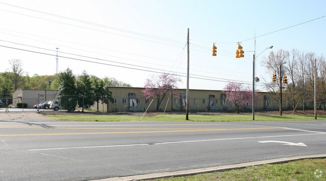
7855 Doral Dr
Winston-Salem, NC
Rjr Tobaccoville
5991-75-3488
RJR TOBACCOVILLE (INSIDE TOB) LO:128P BL:4727 BU:1
Commercialnec
Forsyth
X
North Carolina
3710599100K
128p
2024
6.24 AC
2025
NW Forsyth County
002809
Greensboro/Winston-Salem
40,800 SF
DEMOGRAPHICS near 7855 Doral Dr
1 Mile
3 Mile
5 Mile
2024 Total Population
1,382
12,656
28,397
2029 Population
1,411
13,040
29,412
Pop Growth 2024-2029
+ 2.10%
+ 3.03%
+ 3.57%
Average Age
45
44
43
2024 Total Households
637
5,385
11,866
HH Growth 2024-2029
+ 1.88%
+ 2.99%
+ 3.54%
Median Household Inc
$43,717
$64,012
$63,815
Avg Household Size
2.10
2.30
2.40
2024 Avg HH Vehicles
2.00
2.00
2.00
Median Home Value
$168,674
$179,522
$180,384
Median Year Built
1979
1987
1986
Nearby Places
Map Layers
Map Styles
 Street
 Aerial
- Restaurants
- Banks
- Shops
- Fitness
- Groceries
PUBLIC TRANSPORTATION
AIRPORT
Piedmont Triad International
DRIVE
WALK
Distance
Piedmont Triad International
49 min
32.9 mi
Freight Ports
Virginia Port Authority - Richmond
DRIVE
WALK
Distance
Virginia Port Authority - Richmond
276 min
236.6 mi
Nearby Properties
Address
Land Use
TOTAL SIZE
Lot Size
Zoning
Address
Land Use
TOTAL SIZE
Lot Size
Zoning
2,289,130 SF
555.56 AC
GI
Address
Land Use
TOTAL SIZE
Lot Size
Zoning
525,977 SF
248.96 AC
GI,RS20
Address
Land Use
TOTAL SIZE
Lot Size
Zoning
20,832 SF
53.09 AC
LI KING,RS
Address
Land Use
TOTAL SIZE
Lot Size
Zoning
158,096 SF
16.42 AC
L-I
Address
Land Use
TOTAL SIZE
Lot Size
Zoning
34,444 SF
44.38 AC
B-2,R-MF-T
Address
Land Use
TOTAL SIZE
Lot Size
Zoning
34,444 SF
44.12 AC
B-2,R-MF-T
Address
Land Use
TOTAL SIZE
Lot Size
Zoning
17,714 SF
5.39 AC
R-15
Address
Land Use
TOTAL SIZE
Lot Size
Zoning
51,393 SF
4.68 AC
R-MF
Address
Land Use
TOTAL SIZE
Lot Size
Zoning
56,034 SF
9.68 AC
B-2
Address
Land Use
TOTAL SIZE
Lot Size
Zoning
30,836 SF
9.33 AC
L-I
Address
Land Use
TOTAL SIZE
Lot Size
Zoning
80,634 SF
8.59 AC
B-2
Address
Land Use
TOTAL SIZE
Lot Size
Zoning
34,510 SF
13.74 AC
B-2
Address
Land Use
TOTAL SIZE
Lot Size
Zoning
45,064 SF
5.45 AC
LI,LI KING
Address
Land Use
TOTAL SIZE
Lot Size
Zoning
135,382 SF
10.06 AC
LI KING
Address
Land Use
TOTAL SIZE
Lot Size
Zoning
48,042 SF
14.98 AC
R-20
Address
Land Use
TOTAL SIZE
Lot Size
Zoning
30,276 SF
26.10 AC
AG,IP
Address
Land Use
TOTAL SIZE
Lot Size
Zoning
26,813 SF
2.71 AC
RS20
Address
Land Use
TOTAL SIZE
Lot Size
Zoning
35,040 SF
3.51 AC
L-I
Address
Land Use
TOTAL SIZE
Lot Size
Zoning
32,160 SF
8.30 AC
O-I
Address
Land Use
TOTAL SIZE
Lot Size
Zoning
18,930 SF
2.20 AC
L-I
Address
Land Use
TOTAL SIZE
Lot Size
Zoning
29,553 SF
14.80 AC
R-15
Address
Land Use
TOTAL SIZE
Lot Size
Zoning
12,244 SF
18.58 AC
B-2
Address
Land Use
TOTAL SIZE
Lot Size
Zoning
26,334 SF
22 AC
R-20
Address
Land Use
TOTAL SIZE
Lot Size
Zoning
41,015 SF
2.91 AC
RS20
Address
Land Use
TOTAL SIZE
Lot Size
Zoning
37,604 SF
4.82 AC
R-MF
Address
Land Use
TOTAL SIZE
Lot Size
Zoning
5,250 SF
2.74 AC
B-2
Address
Land Use
TOTAL SIZE
Lot Size
Zoning
9,930 SF
1.65 AC
B-2
Address
Land Use
TOTAL SIZE
Lot Size
Zoning
10,488 SF
4.70 AC
R-MF
Address
Land Use
TOTAL SIZE
Lot Size
Zoning
7,128 SF
5.74 AC
R-MF
Address
Land Use
TOTAL SIZE
Lot Size
Zoning
24,363 SF
1.75 AC
B-2
The World's #1 Commercial Real Estate Marketplace
Connect with us
© 2026 CoStar Group
The information above has been obtained from sources believed reliable. While we do not doubt its accuracy we have not verified it and make no guarantee, warranty or representation about it. It is your responsibility to independently confirm its accuracy and completeness. Any projections, opinions, assumptions, or estimates used are for example only and do not represent the current or future performance of the property. The value of this transaction to you depends on tax and other factors which should be evaluated by your tax, financial, and legal advisors. You and your advisors should conduct a careful, independent investigation of the property to determine to your satisfaction the suitability of the property for your needs.