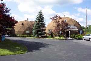
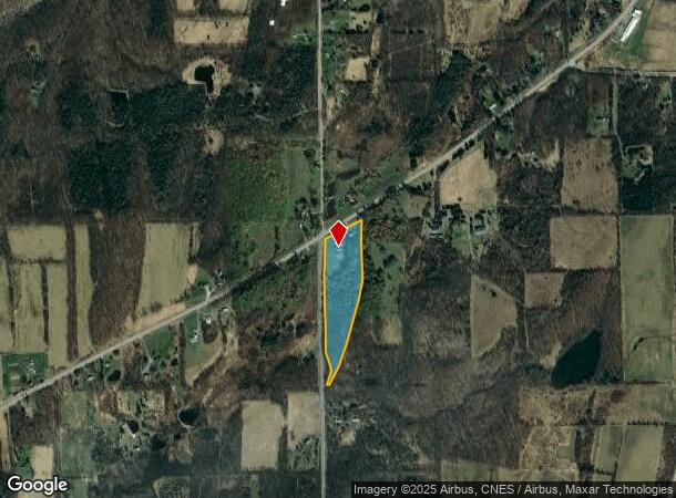
Property Record
7855 State Route 20A, Bloomfield, NY 14469
NEARBY LISTINGS FOR SALE OR LEASE
-
-
View all Bloomfield listings for sale on LoopNet.com
Property Detail
7855 State Route 20A
Rochester, NY
785/1099
322000-123-000-0001-020-210
Ontario
Storebuilding
New York
2025
20.210
2024
10.50 AC
050501
Outlying Ontario County
1,820 SF
Rochester
DEMOGRAPHICS near 7855 State Route 20A
1 Mile
3 Mile
5 Mile
2024 Total Population
197
2,038
5,651
2029 Population
195
2,020
5,631
Pop Growth 2024-2029
(1.02%)
(0.88%)
(0.35%)
Average Age
47
47
47
2024 Total Households
84
889
2,474
HH Growth 2024-2029
(1.19%)
(1.01%)
(0.32%)
Median Household Inc
$82,812
$70,473
$72,329
Avg Household Size
2.30
2.30
2.20
2024 Avg HH Vehicles
2.00
2.00
2.00
Median Home Value
$186,764
$184,023
$198,332
Median Year Built
1980
1976
1973
Nearby Places
Map Layers
Map Styles
 Street
 Aerial
- Restaurants
- Banks
- Shops
- Fitness
- Groceries
PUBLIC TRANSPORTATION
AIRPORT
Frederick Douglass/Greater Rochester International
DRIVE
WALK
Distance
Frederick Douglass/Greater Rochester International
55 min
36.5 mi
Freight Ports
Albany, NY Port
DRIVE
WALK
Distance
Albany, NY Port
264 min
220.2 mi
Nearby Properties
Address
Land Use
TOTAL SIZE
Lot Size
Zoning
Address
Land Use
TOTAL SIZE
Lot Size
Zoning
177,021 SF
43.90 AC
01 - NOT Z
Address
Land Use
TOTAL SIZE
Lot Size
Zoning
2,314 SF
1.20 AC
06 - INDUS
Address
Land Use
TOTAL SIZE
Lot Size
Zoning
124,800 SF
8.50 AC
06 - INDUS
Address
Land Use
TOTAL SIZE
Lot Size
Zoning
75,300 SF
15.10 AC
06 - INDUS
Address
Land Use
TOTAL SIZE
Lot Size
Zoning
1,584 SF
24.70 AC
AC
Address
Land Use
TOTAL SIZE
Lot Size
Zoning
3,360 SF
5.30 AC
05 - COMME
Address
Land Use
TOTAL SIZE
Lot Size
Zoning
4,704 SF
2.90 AC
05 - COMME
Address
Land Use
TOTAL SIZE
Lot Size
Zoning
6,600 SF
4.90 AC
06 - INDUS
Address
Land Use
TOTAL SIZE
Lot Size
Zoning
10,640 SF
3.10 AC
03 - MULTI
Address
Land Use
TOTAL SIZE
Lot Size
Zoning
21,900 SF
2.80 AC
05 - COMME
Address
Land Use
TOTAL SIZE
Lot Size
Zoning
121.70 AC
AC
Address
Land Use
TOTAL SIZE
Lot Size
Zoning
2,240 SF
179.10 AC
AC
Address
Land Use
TOTAL SIZE
Lot Size
Zoning
2,860 SF
2 AC
01 - NOT Z
Address
Land Use
TOTAL SIZE
Lot Size
Zoning
10,426 SF
8.70 AC
05 - COMME
Address
Land Use
TOTAL SIZE
Lot Size
Zoning
1,200 SF
90 AC
AC
Address
Land Use
TOTAL SIZE
Lot Size
Zoning
6,944 SF
1.80 AC
06 - INDUS
Address
Land Use
TOTAL SIZE
Lot Size
Zoning
2,490 SF
76.90 AC
AC
Address
Land Use
TOTAL SIZE
Lot Size
Zoning
3,500 SF
1 AC
06 - INDUS
Address
Land Use
TOTAL SIZE
Lot Size
Zoning
200 SF
81 AC
AC
Address
Land Use
TOTAL SIZE
Lot Size
Zoning
9,275 SF
1 AC
05 - COMME
Address
Land Use
TOTAL SIZE
Lot Size
Zoning
12,000 SF
35 AC
AC
Address
Land Use
TOTAL SIZE
Lot Size
Zoning
2,304 SF
103.80 AC
AC
Address
Land Use
TOTAL SIZE
Lot Size
Zoning
5,220 SF
1.90 AC
AC
Address
Land Use
TOTAL SIZE
Lot Size
Zoning
0.17 AC
01 - NOT Z
Address
Land Use
TOTAL SIZE
Lot Size
Zoning
1,560 SF
18.70 AC
AC
Address
Land Use
TOTAL SIZE
Lot Size
Zoning
45.70 AC
02 - SINGL
Address
Land Use
TOTAL SIZE
Lot Size
Zoning
25,260 SF
2.20 AC
06 - INDUS
Address
Land Use
TOTAL SIZE
Lot Size
Zoning
1,296 SF
11.30 AC
AC
Address
Land Use
TOTAL SIZE
Lot Size
Zoning
2,176 SF
0.74 AC
05 - COMME
The World's #1 Commercial Real Estate Marketplace
Connect with us
© 2025 CoStar Group
The information above has been obtained from sources believed reliable. While we do not doubt its accuracy we have not verified it and make no guarantee, warranty or representation about it. It is your responsibility to independently confirm its accuracy and completeness. Any projections, opinions, assumptions, or estimates used are for example only and do not represent the current or future performance of the property. The value of this transaction to you depends on tax and other factors which should be evaluated by your tax, financial, and legal advisors. You and your advisors should conduct a careful, independent investigation of the property to determine to your satisfaction the suitability of the property for your needs.