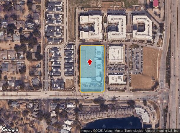
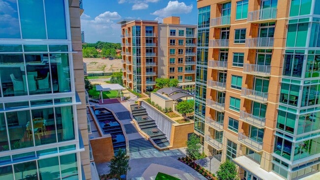
Property Record
7859 Walnut Hill Ln, Dallas, TX 75230

Current Lease Availabilities
NEARBY LISTINGS FOR SALE OR LEASE
Property Detail
7859 Walnut Hill Ln
Dallas-Fort Worth-Arlington, TX
Preston Hollow Village Ph 1
005455000S01B0000
PRESTON HOLLOW VILLAGE PH 1 BLK S/5455 LT 1B ACS 3.178 INT201400093270 DD04032014 CO-DC 5455 00S 01B00 7DA5455 00S
Parkingstructure
Dallas
X
Texas
48113C0195K
1b
2024
3.18 AC
2025
Central Expressway
013104
Dallas/Ft Worth
401,620 SF
DEMOGRAPHICS near 7859 Walnut Hill Ln
1 Mile
3 Mile
5 Mile
2024 Total Population
21,707
154,607
412,804
2029 Population
21,937
154,710
412,775
Pop Growth 2024-2029
+ 1.06%
+ 0.07%
(0.01%)
Average Age
39
38
38
2024 Total Households
11,503
70,124
182,365
HH Growth 2024-2029
+ 0.97%
+ 0.12%
+ 0.01%
Median Household Inc
$59,134
$69,486
$72,241
Avg Household Size
1.80
2.10
2.20
2024 Avg HH Vehicles
1.00
2.00
2.00
Median Home Value
$598,357
$725,929
$585,653
Median Year Built
1983
1981
1979
Nearby Places
Map Layers
Map Styles
 Street
 Aerial
- Restaurants
- Banks
- Shops
- Fitness
- Groceries
PUBLIC TRANSPORTATION
TRANSIT/SUBWAY
Walnut Hill (DART LIGHT RAIL - ORANGE LINE - Dallas Area Rapid Transit (DART), DART LIGHT RAIL - RED LINE - Dallas Area Rapid Transit (DART), Orange Line - Dallas Area Rapid Transit (DART), Red Line - Dallas Area Rapid Transit (DART))
DRIVE
WALK
Distance
Walnut Hill (DART LIGHT RAIL - ORANGE LINE - Dallas Area Rapid Transit (DART), DART LIGHT RAIL - RED LINE - Dallas Area Rapid Transit (DART), Orange Line - Dallas Area Rapid Transit (DART), Red Line - Dallas Area Rapid Transit (DART))
1 min
15 min
0.6 mi
Park Lane (Orange Line - Dallas Area Rapid Transit (DART), Red Line - Dallas Area Rapid Transit (DART))
DRIVE
WALK
Distance
Park Lane (Orange Line - Dallas Area Rapid Transit (DART), Red Line - Dallas Area Rapid Transit (DART))
3 min
20 min
1.1 mi
COMMUTER RAIL
Medical/Market Ctr Station (TRINITY RAILWAY - Dallas Area Rapid Transit (DART))
DRIVE
WALK
Distance
Medical/Market Ctr Station (TRINITY RAILWAY - Dallas Area Rapid Transit (DART))
14 min
8.6 mi
Medical/Market Center (Trinity Railway Express - Dallas Area Rapid Transit (DART))
DRIVE
WALK
Distance
Medical/Market Center (Trinity Railway Express - Dallas Area Rapid Transit (DART))
14 min
8.6 mi
AIRPORT
Dallas Love Field
DRIVE
WALK
Distance
Dallas Love Field
15 min
7.8 mi
Dallas-Fort Worth International
DRIVE
WALK
Distance
Dallas-Fort Worth International
31 min
24.6 mi
Freight Ports
Port of Shreveport
DRIVE
WALK
Distance
Port of Shreveport
218 min
201.9 mi
Nearby Properties
Address
Land Use
TOTAL SIZE
Lot Size
Zoning
Address
Land Use
TOTAL SIZE
Lot Size
Zoning
1,634,356 SF
92.90 AC
Z421
Address
Land Use
TOTAL SIZE
Lot Size
Zoning
4,157,377 SF
76.79 AC
Z248
Address
Land Use
TOTAL SIZE
Lot Size
Zoning
858,872 SF
23.90 AC
Z421
Address
Land Use
TOTAL SIZE
Lot Size
Zoning
2,186,362 SF
48.27 AC
Z239
Address
Land Use
TOTAL SIZE
Lot Size
Zoning
502,529 SF
3.08 AC
Z239
Address
Land Use
TOTAL SIZE
Lot Size
Zoning
1,252,860 SF
57.08 AC
Z239
Address
Land Use
TOTAL SIZE
Lot Size
Zoning
3,423,779 SF
32.42 AC
Z151
Address
Land Use
TOTAL SIZE
Lot Size
Zoning
100 SF
27.05 AC
Z421
Address
Land Use
TOTAL SIZE
Lot Size
Zoning
226,331 SF
1.12 AC
Address
Land Use
TOTAL SIZE
Lot Size
Zoning
77.76 AC
Z239
Address
Land Use
TOTAL SIZE
Lot Size
Zoning
1,086,919 SF
5.85 AC
Z239
Address
Land Use
TOTAL SIZE
Lot Size
Zoning
812,701 SF
3.73 AC
Address
Land Use
TOTAL SIZE
Lot Size
Zoning
557,392 SF
10.06 AC
Z239
Address
Land Use
TOTAL SIZE
Lot Size
Zoning
875,990 SF
4.30 AC
Z239
Address
Land Use
TOTAL SIZE
Lot Size
Zoning
447,418 SF
5.69 AC
Z236
Address
Land Use
TOTAL SIZE
Lot Size
Zoning
662,911 SF
4.36 AC
Z239
Address
Land Use
TOTAL SIZE
Lot Size
Zoning
801,209 SF
1.57 AC
Z239
Address
Land Use
TOTAL SIZE
Lot Size
Zoning
395,377 SF
14.61 AC
Z163
Address
Land Use
TOTAL SIZE
Lot Size
Zoning
601,951 SF
2.10 AC
Z239
Address
Land Use
TOTAL SIZE
Lot Size
Zoning
735,000 SF
2.05 AC
Z239
Address
Land Use
TOTAL SIZE
Lot Size
Zoning
835,301 SF
9.29 AC
Z239
Address
Land Use
TOTAL SIZE
Lot Size
Zoning
674,474 SF
18.81 AC
Z164
Address
Land Use
TOTAL SIZE
Lot Size
Zoning
776,707 SF
8.47 AC
Address
Land Use
TOTAL SIZE
Lot Size
Zoning
717,809 SF
4.88 AC
Z239
Address
Land Use
TOTAL SIZE
Lot Size
Zoning
671,830 SF
3.16 AC
Z239
Address
Land Use
TOTAL SIZE
Lot Size
Zoning
421,798 SF
9 AC
Z151
Address
Land Use
TOTAL SIZE
Lot Size
Zoning
611,755 SF
6.11 AC
Z151
Address
Land Use
TOTAL SIZE
Lot Size
Zoning
540,436 SF
1.86 AC
Z239
Address
Land Use
TOTAL SIZE
Lot Size
Zoning
852,562 SF
13.86 AC
Z151
Address
Land Use
TOTAL SIZE
Lot Size
Zoning
567,135 SF
4.09 AC
Z239
The World's #1 Commercial Real Estate Marketplace
Connect with us
© 2025 CoStar Group
The information above has been obtained from sources believed reliable. While we do not doubt its accuracy we have not verified it and make no guarantee, warranty or representation about it. It is your responsibility to independently confirm its accuracy and completeness. Any projections, opinions, assumptions, or estimates used are for example only and do not represent the current or future performance of the property. The value of this transaction to you depends on tax and other factors which should be evaluated by your tax, financial, and legal advisors. You and your advisors should conduct a careful, independent investigation of the property to determine to your satisfaction the suitability of the property for your needs.