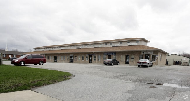
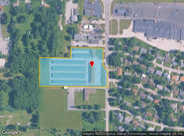
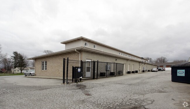
Property Record
786 Mccool Rd, Valparaiso, IN 46385
NEARBY LISTINGS FOR SALE OR LEASE
Property Detail
786 Mccool Rd
64-06-30-226-026.000-015
S275 N898 E660 & E355 S100.4 N622 EX RD ROW NE NE 30-36-6 4.82A
Publicstorage
Porter
X
Indiana
18127C0117D
44 SF
2023
Porter County
2024
Chicago
050505
Chicago-Naperville-Elgin, IL-IN-WI
66,766 SF
DEMOGRAPHICS near 786 Mccool Rd
1 Mile
3 Mile
5 Mile
2024 Total Population
5,385
33,630
76,619
2029 Population
5,352
34,198
78,150
Pop Growth 2024-2029
(0.61%)
+ 1.69%
+ 2.00%
Average Age
38
40
40
2024 Total Households
2,122
12,576
29,137
HH Growth 2024-2029
(0.52%)
+ 1.69%
+ 2.02%
Median Household Inc
$53,557
$71,273
$73,104
Avg Household Size
2.50
2.60
2.60
2024 Avg HH Vehicles
2.00
2.00
2.00
Median Home Value
$144,995
$193,623
$200,091
Median Year Built
1971
1982
1982
Nearby Places
Map Layers
Map Styles
 Street
 Aerial
- Restaurants
- Banks
- Shops
- Fitness
- Groceries
PUBLIC TRANSPORTATION
COMMUTER RAIL
Ogden Dunes (Portage) Station (South Shore Line - Northern Indiana Commuter Transportation District (South Shore Line))
DRIVE
WALK
Distance
Ogden Dunes (Portage) Station (South Shore Line - Northern Indiana Commuter Transportation District (South Shore Line))
16 min
9.4 mi
Miller (Gary) Station (South Shore Line - Northern Indiana Commuter Transportation District (South Shore Line))
DRIVE
WALK
Distance
Miller (Gary) Station (South Shore Line - Northern Indiana Commuter Transportation District (South Shore Line))
19 min
9.5 mi
AIRPORT
Chicago Midway International
DRIVE
WALK
Distance
Chicago Midway International
64 min
43.8 mi
SALE & LEASE HISTORY
LISTING DATE
SALE/LEASE

Sep 25, 2016
For Lease
May 19, 2020
For Lease
Jun 13, 2025
For Lease
Nearby Properties
Address
Land Use
TOTAL SIZE
Lot Size
Zoning
Address
Land Use
TOTAL SIZE
Lot Size
Zoning
218,452 SF
87 SF
Address
Land Use
TOTAL SIZE
Lot Size
Zoning
168,126 SF
44 SF
Address
Land Use
TOTAL SIZE
Lot Size
Zoning
169,427 SF
44 SF
Address
Land Use
TOTAL SIZE
Lot Size
Zoning
215,770 SF
87 SF
Address
Land Use
TOTAL SIZE
Lot Size
Zoning
133,249 SF
44 SF
Address
Land Use
TOTAL SIZE
Lot Size
Zoning
112,216 SF
44 SF
Address
Land Use
TOTAL SIZE
Lot Size
Zoning
140,434 SF
15.26 AC
Address
Land Use
TOTAL SIZE
Lot Size
Zoning
69,459 SF
13.97 AC
Address
Land Use
TOTAL SIZE
Lot Size
Zoning
223,221 SF
87 SF
Address
Land Use
TOTAL SIZE
Lot Size
Zoning
118,798 SF
44 SF
Address
Land Use
TOTAL SIZE
Lot Size
Zoning
50,382 SF
9.83 AC
Address
Land Use
TOTAL SIZE
Lot Size
Zoning
95,281 SF
44 SF
Address
Land Use
TOTAL SIZE
Lot Size
Zoning
191,547 SF
87 SF
Address
Land Use
TOTAL SIZE
Lot Size
Zoning
70,762 SF
3.04 AC
Address
Land Use
TOTAL SIZE
Lot Size
Zoning
96,488 SF
44 SF
Address
Land Use
TOTAL SIZE
Lot Size
Zoning
70,454 SF
1.14 AC
Address
Land Use
TOTAL SIZE
Lot Size
Zoning
70,454 SF
1.20 AC
Address
Land Use
TOTAL SIZE
Lot Size
Zoning
56,308 SF
44 SF
Address
Land Use
TOTAL SIZE
Lot Size
Zoning
51,184 SF
2.50 AC
Address
Land Use
TOTAL SIZE
Lot Size
Zoning
39,644 SF
2.84 AC
Address
Land Use
TOTAL SIZE
Lot Size
Zoning
67,072 SF
44 SF
Address
Land Use
TOTAL SIZE
Lot Size
Zoning
89,232 SF
44 SF
Address
Land Use
TOTAL SIZE
Lot Size
Zoning
71,682 SF
4.40 AC
Address
Land Use
TOTAL SIZE
Lot Size
Zoning
108,527 SF
44 SF
Address
Land Use
TOTAL SIZE
Lot Size
Zoning
134,075 SF
44 SF
Address
Land Use
TOTAL SIZE
Lot Size
Zoning
50,712 SF
2.59 AC
Address
Land Use
TOTAL SIZE
Lot Size
Zoning
15,644 SF
0.03 AC
Address
Land Use
TOTAL SIZE
Lot Size
Zoning
37,252 SF
5.72 AC
Address
Land Use
TOTAL SIZE
Lot Size
Zoning
42,066 SF
13.06 AC
Address
Land Use
TOTAL SIZE
Lot Size
Zoning
37,968 SF
4.14 AC
The World's #1 Commercial Real Estate Marketplace
Connect with us
© 2026 CoStar Group
The information above has been obtained from sources believed reliable. While we do not doubt its accuracy we have not verified it and make no guarantee, warranty or representation about it. It is your responsibility to independently confirm its accuracy and completeness. Any projections, opinions, assumptions, or estimates used are for example only and do not represent the current or future performance of the property. The value of this transaction to you depends on tax and other factors which should be evaluated by your tax, financial, and legal advisors. You and your advisors should conduct a careful, independent investigation of the property to determine to your satisfaction the suitability of the property for your needs.