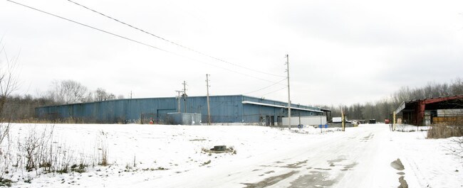
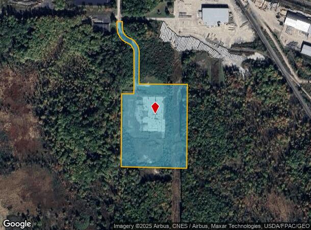
Property Record
7860 Empire Pky, Macedonia, OH 44056
NEARBY LISTINGS FOR SALE OR LEASE
Property Detail
7860 Empire Pky
33-03805
LOT 18 S OF EMPIRE PKWY 17.4737 AC
Commercialnec
Summit
X
Ohio
39035C0345E
18
2023
17.47 AC
2025
Twinsburg/Aurora
532701
Cleveland
98,000 SF
Akron, OH
DEMOGRAPHICS near 7860 Empire Pky
1 Mile
3 Mile
5 Mile
2024 Total Population
2,569
23,576
68,101
2029 Population
2,524
23,100
67,018
Pop Growth 2024-2029
(1.75%)
(2.02%)
(1.59%)
Average Age
43
43
44
2024 Total Households
981
9,196
27,172
HH Growth 2024-2029
(1.83%)
(2.10%)
(1.59%)
Median Household Inc
$116,911
$102,729
$103,113
Avg Household Size
2.60
2.50
2.40
2024 Avg HH Vehicles
2.00
2.00
2.00
Median Home Value
$270,535
$264,781
$283,218
Median Year Built
2001
1987
1985
Nearby Places
Map Layers
Map Styles
 Street
 Aerial
- Restaurants
- Banks
- Shops
- Fitness
- Groceries
PUBLIC TRANSPORTATION
COMMUTER RAIL
Boston Mill (National Park Scenic Railway - Cuyahoga Valley Scenic Railroad)
DRIVE
WALK
Distance
Boston Mill (National Park Scenic Railway - Cuyahoga Valley Scenic Railroad)
15 min
7.3 mi
Peninsula Depot (Lock 29) (National Park Scenic Railway - Cuyahoga Valley Scenic Railroad)
DRIVE
WALK
Distance
Peninsula Depot (Lock 29) (National Park Scenic Railway - Cuyahoga Valley Scenic Railroad)
15 min
9.1 mi
AIRPORT
Cleveland-Hopkins International
DRIVE
WALK
Distance
Cleveland-Hopkins International
43 min
28.5 mi
Akron-Canton Regional
DRIVE
WALK
Distance
Akron-Canton Regional
41 min
30.5 mi
Freight Ports
Port of Toledo
DRIVE
WALK
Distance
Port of Toledo
149 min
126.9 mi
Nearby Properties
Address
Land Use
TOTAL SIZE
Lot Size
Zoning
Address
Land Use
TOTAL SIZE
Lot Size
Zoning
Address
Land Use
TOTAL SIZE
Lot Size
Zoning
315,935 SF
44.94 AC
Address
Land Use
TOTAL SIZE
Lot Size
Zoning
Address
Land Use
TOTAL SIZE
Lot Size
Zoning
1,020,250 SF
63.69 AC
Address
Land Use
TOTAL SIZE
Lot Size
Zoning
Address
Land Use
TOTAL SIZE
Lot Size
Zoning
Address
Land Use
TOTAL SIZE
Lot Size
Zoning
270,968 SF
21.68 AC
Address
Land Use
TOTAL SIZE
Lot Size
Zoning
230,501 SF
39.59 AC
Address
Land Use
TOTAL SIZE
Lot Size
Zoning
155,897 SF
19.81 AC
Address
Land Use
TOTAL SIZE
Lot Size
Zoning
254,828 SF
15.41 AC
Address
Land Use
TOTAL SIZE
Lot Size
Zoning
44,697 SF
17.83 AC
Address
Land Use
TOTAL SIZE
Lot Size
Zoning
418,992 SF
27.87 AC
Address
Land Use
TOTAL SIZE
Lot Size
Zoning
290,113 SF
15.05 AC
Address
Land Use
TOTAL SIZE
Lot Size
Zoning
69,972 SF
15 AC
Address
Land Use
TOTAL SIZE
Lot Size
Zoning
258,840 SF
25.62 AC
Address
Land Use
TOTAL SIZE
Lot Size
Zoning
353,200 SF
25.60 AC
Address
Land Use
TOTAL SIZE
Lot Size
Zoning
111,145 SF
39.21 AC
Address
Land Use
TOTAL SIZE
Lot Size
Zoning
Address
Land Use
TOTAL SIZE
Lot Size
Zoning
130,822 SF
17.50 AC
Address
Land Use
TOTAL SIZE
Lot Size
Zoning
136,800 SF
7.86 AC
Address
Land Use
TOTAL SIZE
Lot Size
Zoning
300,900 SF
10.39 AC
Address
Land Use
TOTAL SIZE
Lot Size
Zoning
204,490 SF
14.52 AC
Address
Land Use
TOTAL SIZE
Lot Size
Zoning
99,400 SF
3.96 AC
Address
Land Use
TOTAL SIZE
Lot Size
Zoning
85,808 SF
10.20 AC
Address
Land Use
TOTAL SIZE
Lot Size
Zoning
263,607 SF
14.69 AC
Address
Land Use
TOTAL SIZE
Lot Size
Zoning
Address
Land Use
TOTAL SIZE
Lot Size
Zoning
Address
Land Use
TOTAL SIZE
Lot Size
Zoning
211,548 SF
14.01 AC
Address
Land Use
TOTAL SIZE
Lot Size
Zoning
41,480 SF
7.09 AC
Address
Land Use
TOTAL SIZE
Lot Size
Zoning
14,247 SF
262 AC
The World's #1 Commercial Real Estate Marketplace
Connect with us
© 2026 CoStar Group
The information above has been obtained from sources believed reliable. While we do not doubt its accuracy we have not verified it and make no guarantee, warranty or representation about it. It is your responsibility to independently confirm its accuracy and completeness. Any projections, opinions, assumptions, or estimates used are for example only and do not represent the current or future performance of the property. The value of this transaction to you depends on tax and other factors which should be evaluated by your tax, financial, and legal advisors. You and your advisors should conduct a careful, independent investigation of the property to determine to your satisfaction the suitability of the property for your needs.