Property Record
7875 E River Rd, Minneapolis, MN 55432
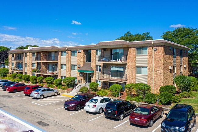
Property Detail
7875 E River Rd
Minneapolis-St. Paul-Bloomington, MN-WI
LOT 1 BLK 1 MEADOW RUN 1ST ADD EX RD, SUBJ TO EASE OF REC
03-30-24-43-0005
ANOKA
Apartment
Minnesota
B and X Area of moderate flood hazard, usually the area between the limits of the 100-year and 500-year floods.
1
2025
3.66 AC
2026
Fridley
051101
Minneapolis/St Paul
64,917 SF
NEARBY LISTINGS FOR SALE OR LEASE
-
-
View all Minneapolis listings for sale on LoopNet.com
DEMOGRAPHICS near 7875 E River Rd
1 mile
3 mile
5 mile
2025 Total Population
8,430
84,917
255,632
2030 Population
8,597
86,010
258,236
Pop Growth 2025-2030
+ 1.98%
+ 1.29%
+ 1.02%
Average Age
40
39
39
2025 Total Households
3,301
31,163
93,272
HH Growth 2025-2030
+ 2.18%
+ 1.50%
+ 1.11%
Median Household Inc
$88,895
$84,358
$83,541
Avg Household Size
2.50
2.60
2.60
2025 Avg HH Vehicles
2.00
2.00
2.00
Median Home Value
$310,442
$305,329
$298,340
Median Year Built
1969
1976
1975
Nearby Places
Map Layers
Map Styles
 Street
 Aerial
Transit
 Traffic
 Biking
Places
Listings with unknown addresses are not visible on the map
- Restaurants
- Banks
- Shops
- Fitness
- Groceries
PUBLIC TRANSPORTATION
COMMUTER RAIL
Fridley Station (Northstar Corridor - Northstar Commuter Rail)
Drive
Walk
Distance
Fridley Station (Northstar Corridor - Northstar Commuter Rail)
6 min
2.7 mi
Coon Rapids-Riverdale Station (Northstar Corridor - Northstar Commuter Rail)
Drive
Walk
Distance
Coon Rapids-Riverdale Station (Northstar Corridor - Northstar Commuter Rail)
16 min
7.4 mi
AIRPORT
Minneapolis-St Paul International/Wold-Chamberlain
Drive
Walk
Distance
Minneapolis-St Paul International/Wold-Chamberlain
38 min
22.3 mi
Freight Ports
Port Milwaukee
Drive
Walk
Distance
Port Milwaukee
385 min
347.8 mi
Nearby Properties
Address
Land Use
TOTAL SIZE
Lot Size
Zoning
Address
Land Use
TOTAL SIZE
Lot Size
Zoning
47,727 SF
17.03 AC
Address
Land Use
TOTAL SIZE
Lot Size
Zoning
35,488 SF
39.07 AC
Address
Land Use
TOTAL SIZE
Lot Size
Zoning
Address
Land Use
TOTAL SIZE
Lot Size
Zoning
417,810 SF
20.60 AC
Address
Land Use
TOTAL SIZE
Lot Size
Zoning
663,908 SF
109.91 AC
Address
Land Use
TOTAL SIZE
Lot Size
Zoning
66,342 SF
8.85 AC
Address
Land Use
TOTAL SIZE
Lot Size
Zoning
Address
Land Use
TOTAL SIZE
Lot Size
Zoning
10.39 AC
Address
Land Use
TOTAL SIZE
Lot Size
Zoning
214,300 SF
9.15 AC
Address
Land Use
TOTAL SIZE
Lot Size
Zoning
229,420 SF
4.14 AC
Address
Land Use
TOTAL SIZE
Lot Size
Zoning
539,671 SF
26.93 AC
Address
Land Use
TOTAL SIZE
Lot Size
Zoning
13,588 SF
129.03 AC
Address
Land Use
TOTAL SIZE
Lot Size
Zoning
249,884 SF
Address
Land Use
TOTAL SIZE
Lot Size
Zoning
Address
Land Use
TOTAL SIZE
Lot Size
Zoning
14,908 SF
28.38 AC
Address
Land Use
TOTAL SIZE
Lot Size
Zoning
12.37 AC
Address
Land Use
TOTAL SIZE
Lot Size
Zoning
Address
Land Use
TOTAL SIZE
Lot Size
Zoning
213,984 SF
12.21 AC
Address
Land Use
TOTAL SIZE
Lot Size
Zoning
194,221 SF
27.83 AC
Address
Land Use
TOTAL SIZE
Lot Size
Zoning
173,183 SF
18.87 AC
Address
Land Use
TOTAL SIZE
Lot Size
Zoning
196 SF
9.81 AC
Address
Land Use
TOTAL SIZE
Lot Size
Zoning
169,628 SF
2.67 AC
Address
Land Use
TOTAL SIZE
Lot Size
Zoning
368,545 SF
18.09 AC
Address
Land Use
TOTAL SIZE
Lot Size
Zoning
10.28 AC
Address
Land Use
TOTAL SIZE
Lot Size
Zoning
345,857 SF
25 AC
Address
Land Use
TOTAL SIZE
Lot Size
Zoning
122,498 SF
31.67 AC
Address
Land Use
TOTAL SIZE
Lot Size
Zoning
128,841 SF
13 AC
Address
Land Use
TOTAL SIZE
Lot Size
Zoning
128,557 SF
12.06 AC
Address
Land Use
TOTAL SIZE
Lot Size
Zoning
198,012 SF
13.07 AC
Address
Land Use
TOTAL SIZE
Lot Size
Zoning
262,452 SF
The World's #1 Commercial Real Estate Marketplace
Connect with us
© 2026 CoStar Group
The information above has been obtained from sources believed reliable. While we do not doubt its accuracy we have not verified it and make no guarantee, warranty or representation about it. It is your responsibility to independently confirm its accuracy and completeness. Any projections, opinions, assumptions, or estimates used are for example only and do not represent the current or future performance of the property. The value of this transaction to you depends on tax and other factors which should be evaluated by your tax, financial, and legal advisors. You and your advisors should conduct a careful, independent investigation of the property to determine to your satisfaction the suitability of the property for your needs.