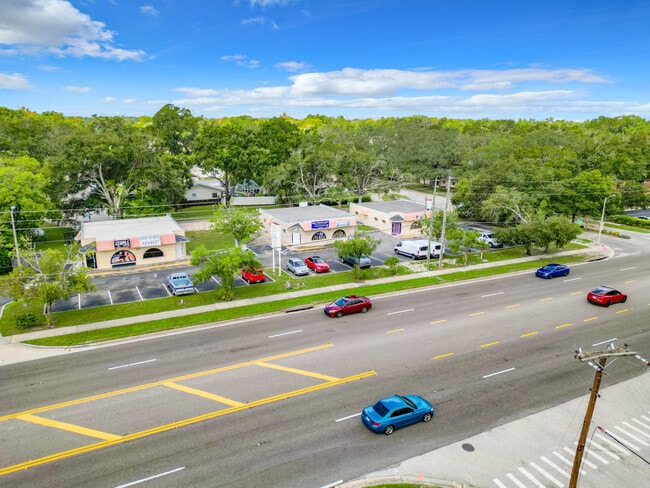
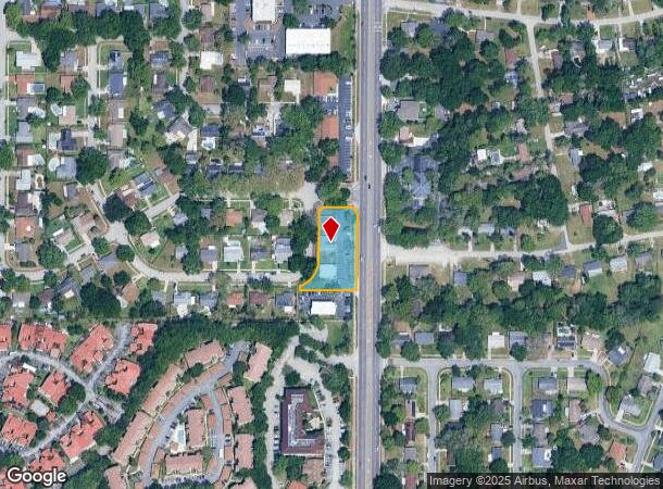
Property Record
790 N State Road 434, Altamonte Springs, FL 32714
NEARBY LISTINGS FOR SALE OR LEASE
Property Detail
790 N State Road 434
Orlando-Kissimmee-Sanford, FL
Northwood
09-21-29-504-0000-0010
LOT 1 & 2 & PT LOTS 3 & 4 BEG NW COR LOT 3 RUN E 121.44 FT S 93.7 FT W 181.29 FT N 12.77 FT NELY ON CURVE TO BEG NORTHWOOD PB 17 PG 42
Storebuilding
Seminole
X
Florida
12095C0145F
1 2
2024
0.54 AC
2024
W Seminole Outlying
021606
Orlando
5,904 SF
DEMOGRAPHICS near 790 N State Road 434
1 Mile
3 Mile
5 Mile
2024 Total Population
12,311
98,751
201,498
2029 Population
12,827
102,803
208,973
Pop Growth 2024-2029
+ 4.19%
+ 4.10%
+ 3.71%
Average Age
40
41
41
2024 Total Households
4,948
41,157
80,721
HH Growth 2024-2029
+ 4.43%
+ 4.33%
+ 3.91%
Median Household Inc
$59,162
$66,033
$63,836
Avg Household Size
2.40
2.30
2.40
2024 Avg HH Vehicles
2.00
2.00
2.00
Median Home Value
$279,382
$331,447
$305,035
Median Year Built
1980
1983
1983
Nearby Places
- Restaurants
- Banks
- Shops
- Fitness
- Groceries
PUBLIC TRANSPORTATION
COMMUTER RAIL
Altamonte Springs (SunRail - Florida Department of Transportation)
DRIVE
WALK
Distance
Altamonte Springs (SunRail - Florida Department of Transportation)
9 min
4.9 mi
Maitland (SunRail - Florida Department of Transportation)
DRIVE
WALK
Distance
Maitland (SunRail - Florida Department of Transportation)
12 min
6.7 mi
AIRPORT
Orlando Sanford International
DRIVE
WALK
Distance
Orlando Sanford International
27 min
16.2 mi
Orlando International
DRIVE
WALK
Distance
Orlando International
38 min
23.6 mi
Freight Ports
Port Canaveral
DRIVE
WALK
Distance
Port Canaveral
84 min
65.6 mi
SALE & LEASE HISTORY
LISTING DATE
SALE/LEASE

May 15, 2024
For Lease
Nearby Properties
Address
Land Use
TOTAL SIZE
Lot Size
Zoning
Address
Land Use
TOTAL SIZE
Lot Size
Zoning
630,861 SF
31.67 AC
PUDMO
Address
Land Use
TOTAL SIZE
Lot Size
Zoning
88,256 SF
39.64 AC
MOC3
Address
Land Use
TOTAL SIZE
Lot Size
Zoning
423,270 SF
3.45 AC
MOC3
Address
Land Use
TOTAL SIZE
Lot Size
Zoning
745,187 SF
18 AC
PUD
Address
Land Use
TOTAL SIZE
Lot Size
Zoning
34,430 SF
19.99 AC
Address
Land Use
TOTAL SIZE
Lot Size
Zoning
1,674 SF
10.53 AC
R3
Address
Land Use
TOTAL SIZE
Lot Size
Zoning
129,745 SF
71.01 AC
PUD
Address
Land Use
TOTAL SIZE
Lot Size
Zoning
357 SF
17.05 AC
Address
Land Use
TOTAL SIZE
Lot Size
Zoning
Address
Land Use
TOTAL SIZE
Lot Size
Zoning
1,416 SF
23.80 AC
Address
Land Use
TOTAL SIZE
Lot Size
Zoning
391,714 SF
42.59 AC
A1
Address
Land Use
TOTAL SIZE
Lot Size
Zoning
381,557 SF
10.09 AC
PD
Address
Land Use
TOTAL SIZE
Lot Size
Zoning
400 SF
13.82 AC
R1AA
Address
Land Use
TOTAL SIZE
Lot Size
Zoning
5,256 SF
1.10 AC
PUDRES
Address
Land Use
TOTAL SIZE
Lot Size
Zoning
11,392 SF
8.44 AC
Address
Land Use
TOTAL SIZE
Lot Size
Zoning
385,111 SF
12.39 AC
PD
Address
Land Use
TOTAL SIZE
Lot Size
Zoning
1,428 SF
8.56 AC
MOR3
Address
Land Use
TOTAL SIZE
Lot Size
Zoning
1,170 SF
17.75 AC
A1
Address
Land Use
TOTAL SIZE
Lot Size
Zoning
5,913 SF
14.46 AC
Address
Land Use
TOTAL SIZE
Lot Size
Zoning
779,046 SF
14.36 AC
PD
Address
Land Use
TOTAL SIZE
Lot Size
Zoning
447,386 SF
5.73 AC
PD
Address
Land Use
TOTAL SIZE
Lot Size
Zoning
254,477 SF
13.14 AC
MOR2
Address
Land Use
TOTAL SIZE
Lot Size
Zoning
268,195 SF
50.24 AC
O
Address
Land Use
TOTAL SIZE
Lot Size
Zoning
5,924 SF
17.38 AC
R1A
Address
Land Use
TOTAL SIZE
Lot Size
Zoning
3,680 SF
17.70 AC
PUD
Address
Land Use
TOTAL SIZE
Lot Size
Zoning
249,311 SF
21.11 AC
R3A
Address
Land Use
TOTAL SIZE
Lot Size
Zoning
3,140 SF
15.89 AC
PUD
Address
Land Use
TOTAL SIZE
Lot Size
Zoning
3,390 SF
18.59 AC
PUD
Address
Land Use
TOTAL SIZE
Lot Size
Zoning
228,362 SF
214.60 AC
PUD
Address
Land Use
TOTAL SIZE
Lot Size
Zoning
226,171 SF
9.97 AC
PD
The World's #1 Commercial Real Estate Marketplace
Connect with us
© 2025 CoStar Group
The information above has been obtained from sources believed reliable. While we do not doubt its accuracy we have not verified it and make no guarantee, warranty or representation about it. It is your responsibility to independently confirm its accuracy and completeness. Any projections, opinions, assumptions, or estimates used are for example only and do not represent the current or future performance of the property. The value of this transaction to you depends on tax and other factors which should be evaluated by your tax, financial, and legal advisors. You and your advisors should conduct a careful, independent investigation of the property to determine to your satisfaction the suitability of the property for your needs.