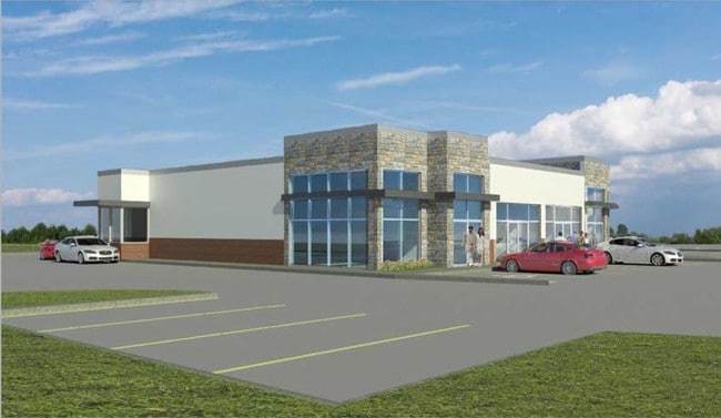
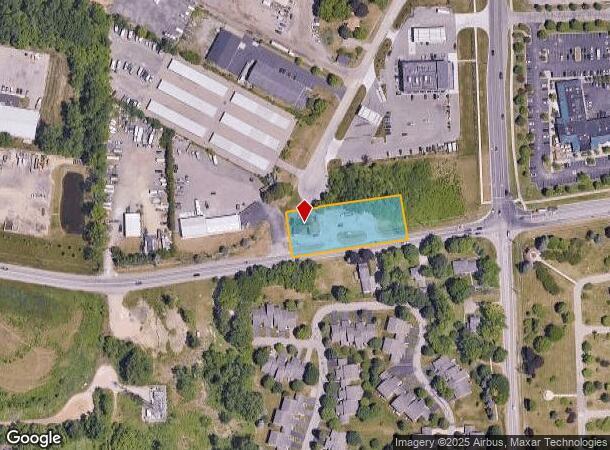
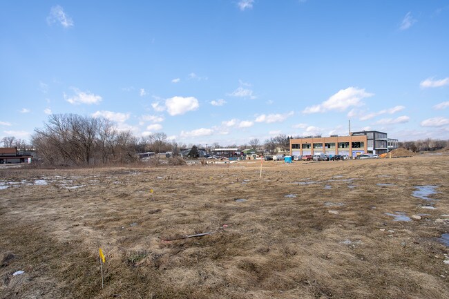
Property Record
7880 Andersonville Rd, Clarkston, MI 48346
NEARBY LISTINGS FOR SALE OR LEASE
Property Detail
7880 Andersonville Rd
08-31-303-003
T4N, R9E, SEC 31 PART OF SW 1/4 BEG AT A PT DIST N 02-17-25 E 68.79 FT & N 85-26-50 E 560.5 FT FROM SW SEC COR 31, TH N 85-26-50 E 335 FT, TH N 04-33-10 W 130 FT, TH S 85-26-50 W 335 FT, TH S 04-26-10 E 130 FT TO BEG 1.00 A 9-29-97 TRANS FR 376-005
Supermarket
Oakland
X
Michigan
26125C0329F
1 AC
2024
Lakes Area
2024
Detroit
127300
Detroit-Warren-Dearborn, MI
2,636 SF
DEMOGRAPHICS near 7880 Andersonville Rd
1 Mile
3 Mile
5 Mile
2024 Total Population
2,164
26,503
82,344
2029 Population
2,130
26,230
81,431
Pop Growth 2024-2029
(1.57%)
(1.03%)
(1.11%)
Average Age
45
43
43
2024 Total Households
932
10,927
33,693
HH Growth 2024-2029
(1.61%)
(1.13%)
(1.19%)
Median Household Inc
$91,374
$90,517
$86,828
Avg Household Size
2.30
2.40
2.40
2024 Avg HH Vehicles
2.00
2.00
2.00
Median Home Value
$260,804
$280,362
$275,090
Median Year Built
1973
1973
1976
Nearby Places
Map Layers
Map Styles
 Street
 Aerial
- Restaurants
- Banks
- Shops
- Fitness
- Groceries
PUBLIC TRANSPORTATION
AIRPORT
Bishop International
DRIVE
WALK
Distance
Bishop International
44 min
28.8 mi
Freight Ports
Port of Toledo
DRIVE
WALK
Distance
Port of Toledo
106 min
83.5 mi
Nearby Properties
Address
Land Use
TOTAL SIZE
Lot Size
Zoning
Address
Land Use
TOTAL SIZE
Lot Size
Zoning
1,075,040 SF
90.26 AC
II
Address
Land Use
TOTAL SIZE
Lot Size
Zoning
208,006 SF
1.24 AC
R2
Address
Land Use
TOTAL SIZE
Lot Size
Zoning
415,169 SF
27.93 AC
II
Address
Land Use
TOTAL SIZE
Lot Size
Zoning
21,719 SF
26.34 AC
R2
Address
Land Use
TOTAL SIZE
Lot Size
Zoning
68,725 SF
4.96 AC
PUD
Address
Land Use
TOTAL SIZE
Lot Size
Zoning
327,288 SF
19.85 AC
R2
Address
Land Use
TOTAL SIZE
Lot Size
Zoning
78,261 SF
7.80 AC
PUD
Address
Land Use
TOTAL SIZE
Lot Size
Zoning
128,290 SF
9.26 AC
BI
Address
Land Use
TOTAL SIZE
Lot Size
Zoning
44.10 AC
PUD
Address
Land Use
TOTAL SIZE
Lot Size
Zoning
87,130 SF
9.01 AC
C-3
Address
Land Use
TOTAL SIZE
Lot Size
Zoning
19,504 SF
3.16 AC
ML
Address
Land Use
TOTAL SIZE
Lot Size
Zoning
327,288 SF
29.09 AC
REC
Address
Land Use
TOTAL SIZE
Lot Size
Zoning
151,736 SF
26.03 AC
C-2
Address
Land Use
TOTAL SIZE
Lot Size
Zoning
111,760 SF
29.33 AC
R2
Address
Land Use
TOTAL SIZE
Lot Size
Zoning
32,059 SF
BLL
Address
Land Use
TOTAL SIZE
Lot Size
Zoning
739 SF
5.36 AC
R1A
Address
Land Use
TOTAL SIZE
Lot Size
Zoning
107,635 SF
8.12 AC
BI
Address
Land Use
TOTAL SIZE
Lot Size
Zoning
143,550 SF
11.92 AC
R2
Address
Land Use
TOTAL SIZE
Lot Size
Zoning
70,140 SF
6.67 AC
BI
Address
Land Use
TOTAL SIZE
Lot Size
Zoning
34,111 SF
20.14 AC
Address
Land Use
TOTAL SIZE
Lot Size
Zoning
82,864 SF
30.65 AC
MH
Address
Land Use
TOTAL SIZE
Lot Size
Zoning
116,816 SF
12.75 AC
R2
Address
Land Use
TOTAL SIZE
Lot Size
Zoning
63,699 SF
0.01 AC
AI
Address
Land Use
TOTAL SIZE
Lot Size
Zoning
30,726 SF
3.44 AC
R3
Address
Land Use
TOTAL SIZE
Lot Size
Zoning
30,711 SF
3.17 AC
PUD
Address
Land Use
TOTAL SIZE
Lot Size
Zoning
2,220 SF
80 AC
REC
Address
Land Use
TOTAL SIZE
Lot Size
Zoning
57,912 SF
BI
Address
Land Use
TOTAL SIZE
Lot Size
Zoning
80,974 SF
8.37 AC
C-3
Address
Land Use
TOTAL SIZE
Lot Size
Zoning
93,759 SF
5.55 AC
BI
Address
Land Use
TOTAL SIZE
Lot Size
Zoning
65,574 SF
2.98 AC
BI
The World's #1 Commercial Real Estate Marketplace
Connect with us
© 2025 CoStar Group
The information above has been obtained from sources believed reliable. While we do not doubt its accuracy we have not verified it and make no guarantee, warranty or representation about it. It is your responsibility to independently confirm its accuracy and completeness. Any projections, opinions, assumptions, or estimates used are for example only and do not represent the current or future performance of the property. The value of this transaction to you depends on tax and other factors which should be evaluated by your tax, financial, and legal advisors. You and your advisors should conduct a careful, independent investigation of the property to determine to your satisfaction the suitability of the property for your needs.