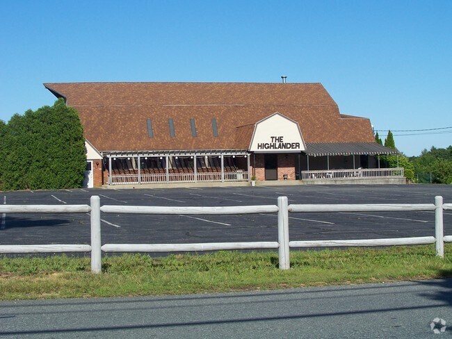
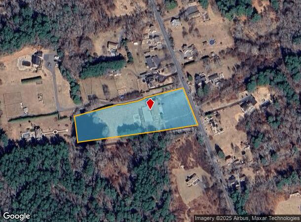
Property Record
789 Main St, Acushnet, MA 02743

NEARBY LISTINGS FOR SALE OR LEASE
Property Detail
789 Main St
Religious
Bristol
X
Massachusetts
25005C0384G
3.29 AC
2025
Attleboro/New Bedford
2025
Boston
654100
Providence-Warwick, RI-MA
5,492 SF
ACUS-000020-000020
DEMOGRAPHICS near 789 Main St
1 Mile
3 Mile
5 Mile
2024 Total Population
763
17,060
62,853
2029 Population
758
16,931
62,040
Pop Growth 2024-2029
(0.66%)
(0.76%)
(1.29%)
Average Age
43
44
41
2024 Total Households
284
6,679
25,534
HH Growth 2024-2029
(0.70%)
(0.84%)
(1.39%)
Median Household Inc
$108,244
$85,496
$68,380
Avg Household Size
2.70
2.50
2.40
2024 Avg HH Vehicles
3.00
2.00
2.00
Median Home Value
$454,761
$379,292
$356,676
Median Year Built
1973
1967
1958
Nearby Places
Map Layers
Map Styles
 Street
 Aerial
- Restaurants
- Banks
- Shops
- Fitness
- Groceries
PUBLIC TRANSPORTATION
AIRPORT
Rhode Island Tf Green International
DRIVE
WALK
Distance
Rhode Island Tf Green International
64 min
42.0 mi
Freight Ports
Port of New Bedford Harbor
DRIVE
WALK
Distance
Port of New Bedford Harbor
16 min
7.2 mi
Nearby Properties
Address
Land Use
TOTAL SIZE
Lot Size
Zoning
Address
Land Use
TOTAL SIZE
Lot Size
Zoning
54.60 AC
Address
Land Use
TOTAL SIZE
Lot Size
Zoning
105,175 SF
7.16 AC
A/R
Address
Land Use
TOTAL SIZE
Lot Size
Zoning
62,408 SF
12.60 AC
RA
Address
Land Use
TOTAL SIZE
Lot Size
Zoning
4,041 SF
31.91 AC
Address
Land Use
TOTAL SIZE
Lot Size
Zoning
46,083 SF
8.43 AC
MUB
Address
Land Use
TOTAL SIZE
Lot Size
Zoning
37,824 SF
1.55 AC
MUB
Address
Land Use
TOTAL SIZE
Lot Size
Zoning
4.50 AC
1
Address
Land Use
TOTAL SIZE
Lot Size
Zoning
3,300 SF
4.69 AC
MUB
Address
Land Use
TOTAL SIZE
Lot Size
Zoning
29,900 SF
4.59 AC
MUB
Address
Land Use
TOTAL SIZE
Lot Size
Zoning
23,928 SF
54.31 AC
Address
Land Use
TOTAL SIZE
Lot Size
Zoning
4.94 AC
1
Address
Land Use
TOTAL SIZE
Lot Size
Zoning
1,500 SF
268.53 AC
1
Address
Land Use
TOTAL SIZE
Lot Size
Zoning
144.81 AC
Address
Land Use
TOTAL SIZE
Lot Size
Zoning
32,588 SF
3.84 AC
MUB
Address
Land Use
TOTAL SIZE
Lot Size
Zoning
1.27 AC
1
Address
Land Use
TOTAL SIZE
Lot Size
Zoning
15,239 SF
2.16 AC
MUB
Address
Land Use
TOTAL SIZE
Lot Size
Zoning
2.08 AC
1
Address
Land Use
TOTAL SIZE
Lot Size
Zoning
3,274 SF
7.50 AC
1
Address
Land Use
TOTAL SIZE
Lot Size
Zoning
10,033 SF
27.76 AC
Address
Land Use
TOTAL SIZE
Lot Size
Zoning
23.56 AC
RB
Address
Land Use
TOTAL SIZE
Lot Size
Zoning
4,356 SF
1.56 AC
MUB
Address
Land Use
TOTAL SIZE
Lot Size
Zoning
1.65 AC
MUB
Address
Land Use
TOTAL SIZE
Lot Size
Zoning
4.76 AC
AR
Address
Land Use
TOTAL SIZE
Lot Size
Zoning
Address
Land Use
TOTAL SIZE
Lot Size
Zoning
26,908 SF
0.81 AC
RA
Address
Land Use
TOTAL SIZE
Lot Size
Zoning
1.39 AC
Address
Land Use
TOTAL SIZE
Lot Size
Zoning
19,591 SF
0.70 AC
RA
Address
Land Use
TOTAL SIZE
Lot Size
Zoning
31,800 SF
2.69 AC
Address
Land Use
TOTAL SIZE
Lot Size
Zoning
12,918 SF
1.16 AC
MUB
Address
Land Use
TOTAL SIZE
Lot Size
Zoning
3,666 SF
1.20 AC
The World's #1 Commercial Real Estate Marketplace
Connect with us
© 2026 CoStar Group
The information above has been obtained from sources believed reliable. While we do not doubt its accuracy we have not verified it and make no guarantee, warranty or representation about it. It is your responsibility to independently confirm its accuracy and completeness. Any projections, opinions, assumptions, or estimates used are for example only and do not represent the current or future performance of the property. The value of this transaction to you depends on tax and other factors which should be evaluated by your tax, financial, and legal advisors. You and your advisors should conduct a careful, independent investigation of the property to determine to your satisfaction the suitability of the property for your needs.