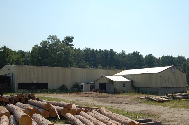
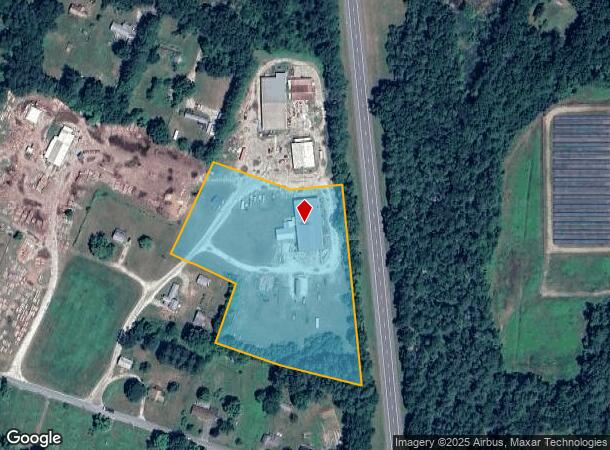
Property Record
79 Clayton Rd, Ashley Falls, MA 01222
NEARBY LISTINGS FOR SALE OR LEASE
Property Detail
79 Clayton Rd
Pittsfield, MA
Berkshire
SHEF-000050-000001-000022
Massachusetts
Truckterminal
2.2
2025
5.75 AC
2025
Massachusetts North/West Area
926100
Other Market Areas
1,152 SF
DEMOGRAPHICS near 79 Clayton Rd
1 Mile
3 Mile
5 Mile
2024 Total Population
409
3,427
6,694
2029 Population
390
3,349
6,521
Pop Growth 2024-2029
(4.65%)
(2.28%)
(2.58%)
Average Age
46
46
47
2024 Total Households
171
1,507
2,950
HH Growth 2024-2029
(4.68%)
(2.26%)
(2.61%)
Median Household Inc
$71,826
$64,451
$67,343
Avg Household Size
2.20
2.20
2.20
2024 Avg HH Vehicles
2.00
2.00
2.00
Median Home Value
$271,969
$282,246
$321,916
Median Year Built
1976
1962
1959
Nearby Places
Map Layers
Map Styles
 Street
 Aerial
- Restaurants
- Banks
- Shops
- Fitness
- Groceries
SALE & LEASE HISTORY
LISTING DATE
SALE/LEASE

Sep 24, 2016
For Sale
Nearby Properties
Address
Land Use
TOTAL SIZE
Lot Size
Zoning
Address
Land Use
TOTAL SIZE
Lot Size
Zoning
123,049 SF
43.87 AC
2
Address
Land Use
TOTAL SIZE
Lot Size
Zoning
44.80 AC
2
Address
Land Use
TOTAL SIZE
Lot Size
Zoning
124.26 AC
1
Address
Land Use
TOTAL SIZE
Lot Size
Zoning
58,782 SF
7.63 AC
3
Address
Land Use
TOTAL SIZE
Lot Size
Zoning
225.40 AC
NM
Address
Land Use
TOTAL SIZE
Lot Size
Zoning
12.88 AC
2
Address
Land Use
TOTAL SIZE
Lot Size
Zoning
11 AC
5
Address
Land Use
TOTAL SIZE
Lot Size
Zoning
1,219.10 AC
MR
Address
Land Use
TOTAL SIZE
Lot Size
Zoning
34,997 SF
2.87 AC
2
Address
Land Use
TOTAL SIZE
Lot Size
Zoning
24.27 AC
3
Address
Land Use
TOTAL SIZE
Lot Size
Zoning
25.02 AC
RR1
Address
Land Use
TOTAL SIZE
Lot Size
Zoning
5,851 SF
4.22 AC
RR1
Address
Land Use
TOTAL SIZE
Lot Size
Zoning
3.57 AC
3
Address
Land Use
TOTAL SIZE
Lot Size
Zoning
1,062 SF
27.13 AC
5
Address
Land Use
TOTAL SIZE
Lot Size
Zoning
2,844 SF
4.48 AC
2
Address
Land Use
TOTAL SIZE
Lot Size
Zoning
2,152 SF
14.52 AC
R1
Address
Land Use
TOTAL SIZE
Lot Size
Zoning
38,269 SF
4.10 AC
GB
Address
Land Use
TOTAL SIZE
Lot Size
Zoning
2,212 SF
1.18 AC
RR1
Address
Land Use
TOTAL SIZE
Lot Size
Zoning
Address
Land Use
TOTAL SIZE
Lot Size
Zoning
4.68 AC
RR1
Address
Land Use
TOTAL SIZE
Lot Size
Zoning
49,005 SF
2.64 AC
C
Address
Land Use
TOTAL SIZE
Lot Size
Zoning
217.43 AC
1
Address
Land Use
TOTAL SIZE
Lot Size
Zoning
10.78 AC
2
Address
Land Use
TOTAL SIZE
Lot Size
Zoning
9,971 SF
0.92 AC
3
Address
Land Use
TOTAL SIZE
Lot Size
Zoning
4,712 SF
9.08 AC
Address
Land Use
TOTAL SIZE
Lot Size
Zoning
2.56 AC
3
Address
Land Use
TOTAL SIZE
Lot Size
Zoning
816 SF
10.60 AC
RR1
Address
Land Use
TOTAL SIZE
Lot Size
Zoning
5.17 AC
LA
Address
Land Use
TOTAL SIZE
Lot Size
Zoning
4.53 AC
RR1
Address
Land Use
TOTAL SIZE
Lot Size
Zoning
3.51 AC
RR1
The World's #1 Commercial Real Estate Marketplace
Connect with us
© 2025 CoStar Group
The information above has been obtained from sources believed reliable. While we do not doubt its accuracy we have not verified it and make no guarantee, warranty or representation about it. It is your responsibility to independently confirm its accuracy and completeness. Any projections, opinions, assumptions, or estimates used are for example only and do not represent the current or future performance of the property. The value of this transaction to you depends on tax and other factors which should be evaluated by your tax, financial, and legal advisors. You and your advisors should conduct a careful, independent investigation of the property to determine to your satisfaction the suitability of the property for your needs.