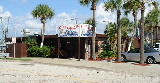
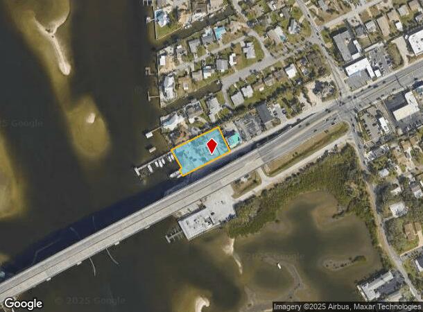
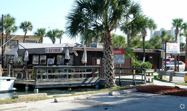
Property Record
79 Dunlawton Ave, Port Orange, FL 32127

NEARBY LISTINGS FOR SALE OR LEASE
Property Detail
79 Dunlawton Ave
6302-00-00-0080
Dunlawton
Restaurantbuilding
S 145.05 FT ON W/L OF LAND N OF DUNLAWTON BLVD & W OF PEN DR LYING OPPOSITE BLK G PORT ORANGE BCH EXC E 608 FT INC RIP RTS PER OR 3796 PG 1619 PER OR 5633 PG 1165 & PER OR 6356 PG 0360 PER OR 6356 PG 0363
AE
Volusia
12127C0388J
Florida
2025
0.81 AC
2025
Coastal Daytona Beach
082605
Deltona/Daytona Beach
8,851 SF
Deltona-Daytona Beach-Ormond Beach, FL
DEMOGRAPHICS near 79 Dunlawton Ave
1 Mile
3 Mile
5 Mile
2024 Total Population
4,595
42,082
106,928
2029 Population
5,389
47,350
119,123
Pop Growth 2024-2029
+ 17.28%
+ 12.52%
+ 11.40%
Average Age
55
49
46
2024 Total Households
2,384
20,391
48,935
HH Growth 2024-2029
+ 17.74%
+ 12.90%
+ 11.93%
Median Household Inc
$65,487
$49,235
$52,209
Avg Household Size
1.90
2.00
2.10
2024 Avg HH Vehicles
1.00
2.00
2.00
Median Home Value
$360,966
$225,497
$233,483
Median Year Built
1982
1979
1982
Nearby Places
Map Layers
Map Styles
 Street
 Aerial
- Restaurants
- Banks
- Shops
- Fitness
- Groceries
PUBLIC TRANSPORTATION
AIRPORT
Daytona Beach International
DRIVE
WALK
Distance
Daytona Beach International
18 min
8.7 mi
Freight Ports
Port Canaveral
DRIVE
WALK
Distance
Port Canaveral
83 min
68.9 mi
Nearby Properties
Address
Land Use
TOTAL SIZE
Lot Size
Zoning
Address
Land Use
TOTAL SIZE
Lot Size
Zoning
325,744 SF
12.23 AC
Address
Land Use
TOTAL SIZE
Lot Size
Zoning
269,133 SF
6.33 AC
Address
Land Use
TOTAL SIZE
Lot Size
Zoning
94,338 SF
7.39 AC
Address
Land Use
TOTAL SIZE
Lot Size
Zoning
9,952 SF
9.30 AC
16RMH
Address
Land Use
TOTAL SIZE
Lot Size
Zoning
9,061 SF
0.23 AC
16RMH
Address
Land Use
TOTAL SIZE
Lot Size
Zoning
3,886 SF
3.99 AC
16RMH
Address
Land Use
TOTAL SIZE
Lot Size
Zoning
Address
Land Use
TOTAL SIZE
Lot Size
Zoning
173,765 SF
0.32 AC
Address
Land Use
TOTAL SIZE
Lot Size
Zoning
9,833 SF
52.38 AC
16RMH
Address
Land Use
TOTAL SIZE
Lot Size
Zoning
131,376 SF
1.88 AC
03T
Address
Land Use
TOTAL SIZE
Lot Size
Zoning
212,782 SF
0.71 AC
Address
Land Use
TOTAL SIZE
Lot Size
Zoning
4,166 SF
51.05 AC
Address
Land Use
TOTAL SIZE
Lot Size
Zoning
157,147 SF
47.79 AC
16A
Address
Land Use
TOTAL SIZE
Lot Size
Zoning
327,223 SF
21.66 AC
Address
Land Use
TOTAL SIZE
Lot Size
Zoning
19,753 SF
1.17 AC
Address
Land Use
TOTAL SIZE
Lot Size
Zoning
109,265 SF
13.45 AC
Address
Land Use
TOTAL SIZE
Lot Size
Zoning
138,930 SF
13.70 AC
16PCD
Address
Land Use
TOTAL SIZE
Lot Size
Zoning
79,205 SF
1.13 AC
03T
Address
Land Use
TOTAL SIZE
Lot Size
Zoning
95,455 SF
1.45 AC
03T
Address
Land Use
TOTAL SIZE
Lot Size
Zoning
80,836 SF
3.03 AC
R3
Address
Land Use
TOTAL SIZE
Lot Size
Zoning
102,229 SF
1.60 AC
Address
Land Use
TOTAL SIZE
Lot Size
Zoning
117,890 SF
11.97 AC
Address
Land Use
TOTAL SIZE
Lot Size
Zoning
111,559 SF
5.80 AC
Address
Land Use
TOTAL SIZE
Lot Size
Zoning
5,026 SF
28 AC
16RMH
Address
Land Use
TOTAL SIZE
Lot Size
Zoning
81,793 SF
1.66 AC
03T
Address
Land Use
TOTAL SIZE
Lot Size
Zoning
173,716 SF
6.76 AC
Address
Land Use
TOTAL SIZE
Lot Size
Zoning
1,940 SF
25.37 AC
Address
Land Use
TOTAL SIZE
Lot Size
Zoning
52,536 SF
1.29 AC
03T
Address
Land Use
TOTAL SIZE
Lot Size
Zoning
105,559 SF
19.97 AC
Address
Land Use
TOTAL SIZE
Lot Size
Zoning
87,320 SF
5.52 AC
The World's #1 Commercial Real Estate Marketplace
Connect with us
© 2025 CoStar Group
The information above has been obtained from sources believed reliable. While we do not doubt its accuracy we have not verified it and make no guarantee, warranty or representation about it. It is your responsibility to independently confirm its accuracy and completeness. Any projections, opinions, assumptions, or estimates used are for example only and do not represent the current or future performance of the property. The value of this transaction to you depends on tax and other factors which should be evaluated by your tax, financial, and legal advisors. You and your advisors should conduct a careful, independent investigation of the property to determine to your satisfaction the suitability of the property for your needs.