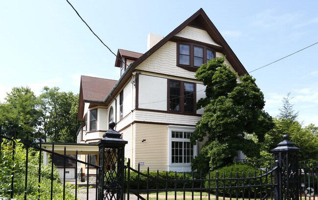
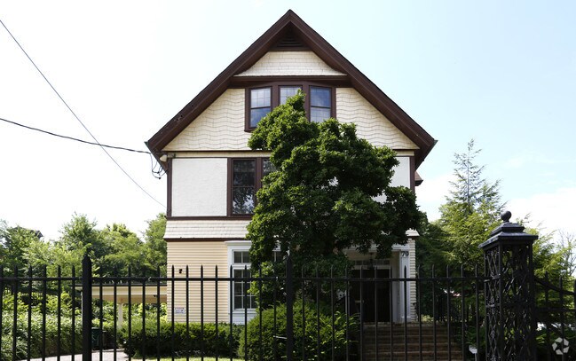
Property Record
79 E Hollister St, Cincinnati, OH 45219
NEARBY LISTINGS FOR SALE OR LEASE
Property Detail
79 E Hollister St
088-0009-0038
79 HOLLISTER ST 50 X 150 SS HOLLISTER 304 FT W OF AUBURN
Commercialofficeresidentialmixeduse
Hamilton
X
Ohio
39061C0219E
0.20 AC
2024
Clifton/Midtown
2024
Cincinnati/Dayton
002300
Cincinnati, OH-KY-IN
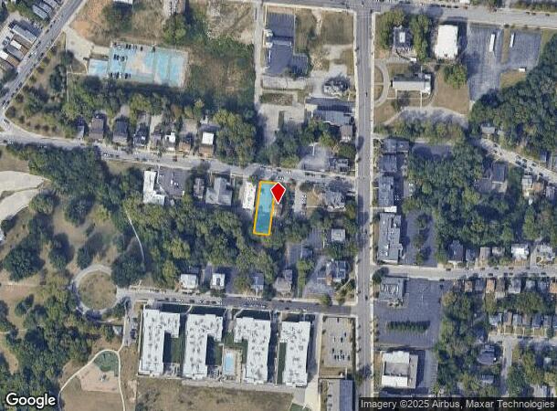
DEMOGRAPHICS near 79 E Hollister St
1 Mile
3 Mile
5 Mile
2024 Total Population
33,778
155,772
343,367
2029 Population
34,235
158,630
346,536
Pop Growth 2024-2029
+ 1.35%
+ 1.83%
+ 0.92%
Average Age
29
36
37
2024 Total Households
12,511
70,458
152,286
HH Growth 2024-2029
+ 1.81%
+ 1.97%
+ 0.92%
Median Household Inc
$34,684
$45,536
$48,088
Avg Household Size
2.00
1.90
2.10
2024 Avg HH Vehicles
1.00
1.00
1.00
Median Home Value
$250,831
$241,445
$211,318
Median Year Built
1949
1949
1949
Nearby Places
Map Layers
Map Styles
 Street
 Aerial
- Restaurants
- Banks
- Shops
- Fitness
- Groceries
PUBLIC TRANSPORTATION
TRANSIT/SUBWAY
Brewery District Station, Elm & Henry (Streetcar - OTR - Banks - Southwest Ohio Regional Transit Authority)
DRIVE
WALK
Distance
Brewery District Station, Elm & Henry (Streetcar - OTR - Banks - Southwest Ohio Regional Transit Authority)
3 min
19 min
1.0 mi
Findlay Market-Race Station, Race & Elder (Streetcar - OTR - Banks - Southwest Ohio Regional Transit Authority)
DRIVE
WALK
Distance
Findlay Market-Race Station, Race & Elder (Streetcar - OTR - Banks - Southwest Ohio Regional Transit Authority)
3 min
20 min
1.1 mi
COMMUTER RAIL
Cincinnati Union Terminal (Cardinal - Amtrak)
DRIVE
WALK
Distance
Cincinnati Union Terminal (Cardinal - Amtrak)
8 min
2.5 mi
AIRPORT
Cincinnati/Northern Kentucky International
DRIVE
WALK
Distance
Cincinnati/Northern Kentucky International
32 min
16.1 mi
Freight Ports
Port of Toledo
DRIVE
WALK
Distance
Port of Toledo
240 min
203.3 mi
SALE & LEASE HISTORY
LISTING DATE
SALE/LEASE

Sep 25, 2016
For Lease
Nearby Properties
Address
Land Use
TOTAL SIZE
Lot Size
Zoning
Address
Land Use
TOTAL SIZE
Lot Size
Zoning
77.73 AC
IR
Address
Land Use
TOTAL SIZE
Lot Size
Zoning
6.35 AC
IR
Address
Land Use
TOTAL SIZE
Lot Size
Zoning
39.99 AC
MG
Address
Land Use
TOTAL SIZE
Lot Size
Zoning
11.82 AC
Address
Land Use
TOTAL SIZE
Lot Size
Zoning
19.36 AC
Address
Land Use
TOTAL SIZE
Lot Size
Zoning
17.10 AC
DD
Address
Land Use
TOTAL SIZE
Lot Size
Zoning
1.97 AC
DD
Address
Land Use
TOTAL SIZE
Lot Size
Zoning
62.10 AC
Address
Land Use
TOTAL SIZE
Lot Size
Zoning
11.41 AC
IR
Address
Land Use
TOTAL SIZE
Lot Size
Zoning
22.45 AC
Address
Land Use
TOTAL SIZE
Lot Size
Zoning
13.80 AC
Address
Land Use
TOTAL SIZE
Lot Size
Zoning
60,750 SF
1.52 AC
Address
Land Use
TOTAL SIZE
Lot Size
Zoning
2.60 AC
Address
Land Use
TOTAL SIZE
Lot Size
Zoning
9.55 AC
Address
Land Use
TOTAL SIZE
Lot Size
Zoning
3.09 AC
Address
Land Use
TOTAL SIZE
Lot Size
Zoning
2.80 AC
IR
Address
Land Use
TOTAL SIZE
Lot Size
Zoning
3.40 AC
IR
Address
Land Use
TOTAL SIZE
Lot Size
Zoning
89,500 SF
0.58 AC
Address
Land Use
TOTAL SIZE
Lot Size
Zoning
Address
Land Use
TOTAL SIZE
Lot Size
Zoning
290,233 SF
Address
Land Use
TOTAL SIZE
Lot Size
Zoning
3.51 AC
DD
Address
Land Use
TOTAL SIZE
Lot Size
Zoning
Address
Land Use
TOTAL SIZE
Lot Size
Zoning
153,312 SF
4 AC
Address
Land Use
TOTAL SIZE
Lot Size
Zoning
9.14 AC
Address
Land Use
TOTAL SIZE
Lot Size
Zoning
11.68 AC
Address
Land Use
TOTAL SIZE
Lot Size
Zoning
298,611 SF
Address
Land Use
TOTAL SIZE
Lot Size
Zoning
7.14 AC
Address
Land Use
TOTAL SIZE
Lot Size
Zoning
256,000 SF
Address
Land Use
TOTAL SIZE
Lot Size
Zoning
1.95 AC
Address
Land Use
TOTAL SIZE
Lot Size
Zoning
The World's #1 Commercial Real Estate Marketplace
Connect with us
© 2025 CoStar Group
The information above has been obtained from sources believed reliable. While we do not doubt its accuracy we have not verified it and make no guarantee, warranty or representation about it. It is your responsibility to independently confirm its accuracy and completeness. Any projections, opinions, assumptions, or estimates used are for example only and do not represent the current or future performance of the property. The value of this transaction to you depends on tax and other factors which should be evaluated by your tax, financial, and legal advisors. You and your advisors should conduct a careful, independent investigation of the property to determine to your satisfaction the suitability of the property for your needs.