Property Record
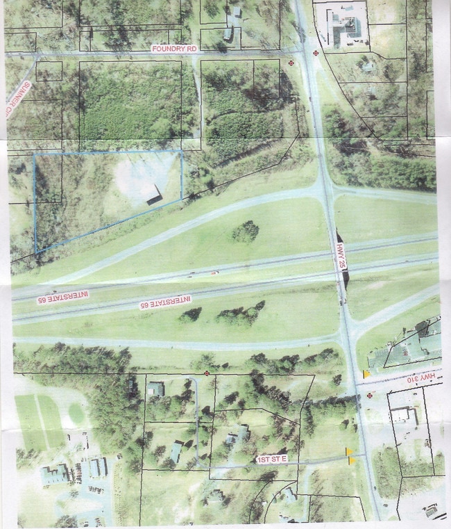
79 Foundry Rd, Calera, AL 35040

Property Detail
79 Foundry Rd
28-5-22-3-001-038-000
COM SW COR SE1/4 SW1/4 N655.28 TO POB CONT N600 E196.99 TO W ROW I-65 HWY SLY639.14 W423.44 TO POB
Warehouse
Shelby
B and X Area of moderate flood hazard, usually the area between the limits of the 100-year and 500-year floods.
Alabama
2025
3.77 AC
2025
I-65 Corr/S Shelby County
030504
Birmingham
3,000 SF
Birmingham, AL
NEARBY LISTINGS FOR SALE OR LEASE
DEMOGRAPHICS near 79 Foundry Rd
1 mile
3 mile
5 mile
2025 Total Population
1,628
9,840
20,939
2030 Population
1,702
10,359
21,934
Pop Growth 2025-2030
+ 4.55%
+ 5.27%
+ 4.75%
Average Age
37
36
37
2025 Total Households
599
3,579
7,771
HH Growth 2025-2030
+ 4.51%
+ 5.28%
+ 4.72%
Median Household Inc
$72,499
$71,146
$74,910
Avg Household Size
2.70
2.70
2.60
2025 Avg HH Vehicles
2.00
2.00
2.00
Median Home Value
$254,687
$240,265
$235,947
Median Year Built
2001
2003
2003
Nearby Places
Map Layers
Map Styles
 Street
 Aerial
Layers
 Traffic
 Biking
Places
Listings with unknown addresses are not visible on the map
- Restaurants
- Banks
- Shops
- Fitness
- Groceries
PUBLIC TRANSPORTATION
AIRPORT
Birmingham-Shuttlesworth International
Drive
Walk
Distance
Birmingham-Shuttlesworth International
47 min
37.7 mi
Nearby Properties
Address
Land Use
TOTAL SIZE
Lot Size
Zoning
Address
Land Use
TOTAL SIZE
Lot Size
Zoning
222,078 SF
14.10 AC
Address
Land Use
TOTAL SIZE
Lot Size
Zoning
1,880 SF
7.80 AC
Address
Land Use
TOTAL SIZE
Lot Size
Zoning
97,384 SF
2.94 AC
Address
Land Use
TOTAL SIZE
Lot Size
Zoning
104,643 SF
5.39 AC
Address
Land Use
TOTAL SIZE
Lot Size
Zoning
8,328 SF
6.89 AC
Address
Land Use
TOTAL SIZE
Lot Size
Zoning
73,825 SF
15 AC
Address
Land Use
TOTAL SIZE
Lot Size
Zoning
600 SF
69 AC
Address
Land Use
TOTAL SIZE
Lot Size
Zoning
33,440 SF
5.23 AC
Address
Land Use
TOTAL SIZE
Lot Size
Zoning
38,816 SF
33.96 AC
Address
Land Use
TOTAL SIZE
Lot Size
Zoning
40,295 SF
0.60 AC
Address
Land Use
TOTAL SIZE
Lot Size
Zoning
Address
Land Use
TOTAL SIZE
Lot Size
Zoning
36,430 SF
4.10 AC
Address
Land Use
TOTAL SIZE
Lot Size
Zoning
2,400 SF
13 AC
Address
Land Use
TOTAL SIZE
Lot Size
Zoning
66,260 SF
3.84 AC
Address
Land Use
TOTAL SIZE
Lot Size
Zoning
29,000 SF
5.91 AC
Address
Land Use
TOTAL SIZE
Lot Size
Zoning
8,120 SF
24 AC
Address
Land Use
TOTAL SIZE
Lot Size
Zoning
14,700 SF
12 AC
Address
Land Use
TOTAL SIZE
Lot Size
Zoning
17,950 SF
8.89 AC
Address
Land Use
TOTAL SIZE
Lot Size
Zoning
47,480 SF
19.86 AC
Address
Land Use
TOTAL SIZE
Lot Size
Zoning
24,000 SF
14 AC
Address
Land Use
TOTAL SIZE
Lot Size
Zoning
10,268 SF
5 AC
Address
Land Use
TOTAL SIZE
Lot Size
Zoning
25,980 SF
2.43 AC
Address
Land Use
TOTAL SIZE
Lot Size
Zoning
5,192 SF
71.12 AC
Address
Land Use
TOTAL SIZE
Lot Size
Zoning
14,058 SF
21 AC
Address
Land Use
TOTAL SIZE
Lot Size
Zoning
13,304 SF
1.41 AC
Address
Land Use
TOTAL SIZE
Lot Size
Zoning
10,500 SF
5 AC
Address
Land Use
TOTAL SIZE
Lot Size
Zoning
7,950 SF
1.08 AC
Address
Land Use
TOTAL SIZE
Lot Size
Zoning
21,286 SF
1.40 AC
Address
Land Use
TOTAL SIZE
Lot Size
Zoning
13,355 SF
29.90 AC
Address
Land Use
TOTAL SIZE
Lot Size
Zoning
5,000 SF
174 AC
The World's #1 Commercial Real Estate Marketplace
Connect with us
© 2026 CoStar Group
The information above has been obtained from sources believed reliable. While we do not doubt its accuracy we have not verified it and make no guarantee, warranty or representation about it. It is your responsibility to independently confirm its accuracy and completeness. Any projections, opinions, assumptions, or estimates used are for example only and do not represent the current or future performance of the property. The value of this transaction to you depends on tax and other factors which should be evaluated by your tax, financial, and legal advisors. You and your advisors should conduct a careful, independent investigation of the property to determine to your satisfaction the suitability of the property for your needs.