Property Record
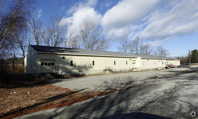
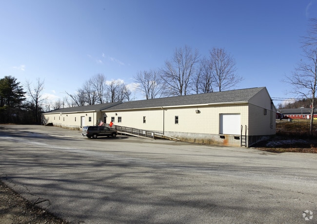
79 Hadley Rd, Jaffrey, NH 03452

Save to a Folder
{{folder.Name}}
{{folder.ListingIds.length}} Properties
{{folder.ListingIds.length}} Property
Create a New Folder
Property Detail
79 Hadley Rd
Departmentstore
Cheshire
IND
New Hampshire
AE The base floodplain where base flood elevations are provided. AE Zones are now used on new format FIRMs instead of A1-A30 Zones.
0.76 AC
2025
Other Market Areas
2025
Keene, NH
970500
JAFF-000254-000005
11,000 SF
NEARBY LISTINGS FOR SALE OR LEASE
-
-
View all Jaffrey listings for sale on LoopNet.com
DEMOGRAPHICS near 79 Hadley Rd
1 mile
3 mile
5 mile
2025 Total Population
550
5,537
16,070
2030 Population
558
5,647
16,689
Pop Growth 2025-2030
+ 1.45%
+ 1.99%
+ 3.85%
Average Age
43
43
43
2025 Total Households
232
2,275
6,330
HH Growth 2025-2030
+ 1.29%
+ 2.11%
+ 4.12%
Median Household Inc
$92,338
$102,220
$102,183
Avg Household Size
2.30
2.30
2.30
2025 Avg HH Vehicles
2.00
2.00
2.00
Median Home Value
$277,631
$323,486
$403,283
Median Year Built
1975
1971
1978
Nearby Places
Map Layers
Map Styles
 Street
 Aerial
Layers
 Traffic
 Biking
Places
Listings with unknown addresses are not visible on the map
- Restaurants
- Banks
- Shops
- Fitness
- Groceries
PUBLIC TRANSPORTATION
AIRPORT
Manchester Boston Regional
Drive
Walk
Distance
Manchester Boston Regional
71 min
41.1 mi
Freight Ports
Port of Boston
Drive
Walk
Distance
Port of Boston
117 min
67.8 mi
Nearby Properties
Address
Land Use
TOTAL SIZE
Lot Size
Zoning
Address
Land Use
TOTAL SIZE
Lot Size
Zoning
67,754 SF
28 AC
RB2
Address
Land Use
TOTAL SIZE
Lot Size
Zoning
4.36 AC
RA1
Address
Land Use
TOTAL SIZE
Lot Size
Zoning
2,276 SF
146 AC
IND
Address
Land Use
TOTAL SIZE
Lot Size
Zoning
56,684 SF
3.51 AC
RA2
Address
Land Use
TOTAL SIZE
Lot Size
Zoning
25.40 AC
INDUST
Address
Land Use
TOTAL SIZE
Lot Size
Zoning
44.39 AC
Address
Land Use
TOTAL SIZE
Lot Size
Zoning
80,781 SF
8.88 AC
IND
Address
Land Use
TOTAL SIZE
Lot Size
Zoning
30,677 SF
5.14 AC
IND
Address
Land Use
TOTAL SIZE
Lot Size
Zoning
39,133 SF
10.88 AC
GB
Address
Land Use
TOTAL SIZE
Lot Size
Zoning
17,360 SF
4.01 AC
RA2
Address
Land Use
TOTAL SIZE
Lot Size
Zoning
32,597 SF
5.17 AC
GB
Address
Land Use
TOTAL SIZE
Lot Size
Zoning
20,767 SF
6.10 AC
RA1
Address
Land Use
TOTAL SIZE
Lot Size
Zoning
94,400 SF
7.18 AC
IND
Address
Land Use
TOTAL SIZE
Lot Size
Zoning
5,888 SF
8.35 AC
RA2
Address
Land Use
TOTAL SIZE
Lot Size
Zoning
16,096 SF
2.89 AC
GB
Address
Land Use
TOTAL SIZE
Lot Size
Zoning
28,141 SF
72.70 AC
IND
Address
Land Use
TOTAL SIZE
Lot Size
Zoning
41.36 AC
R
Address
Land Use
TOTAL SIZE
Lot Size
Zoning
25,600 SF
9.38 AC
IND
Address
Land Use
TOTAL SIZE
Lot Size
Zoning
4.73 AC
I
Address
Land Use
TOTAL SIZE
Lot Size
Zoning
9,628 SF
3.70 AC
R2
Address
Land Use
TOTAL SIZE
Lot Size
Zoning
13,842 SF
19.99 AC
R1
Address
Land Use
TOTAL SIZE
Lot Size
Zoning
8,716 SF
0.77 AC
GB
Address
Land Use
TOTAL SIZE
Lot Size
Zoning
6,736 SF
7 AC
RA2
Address
Land Use
TOTAL SIZE
Lot Size
Zoning
3,200 SF
49 AC
R1
Address
Land Use
TOTAL SIZE
Lot Size
Zoning
22,400 SF
2.02 AC
IND
Address
Land Use
TOTAL SIZE
Lot Size
Zoning
5,950 SF
4.56 AC
IND
Address
Land Use
TOTAL SIZE
Lot Size
Zoning
40,120 SF
1.32 AC
GB
Address
Land Use
TOTAL SIZE
Lot Size
Zoning
33,252 SF
3.12 AC
IND
Address
Land Use
TOTAL SIZE
Lot Size
Zoning
37,064 SF
5.10 AC
IND
Address
Land Use
TOTAL SIZE
Lot Size
Zoning
8,400 SF
1.90 AC
R2
The World's #1 Commercial Real Estate Marketplace
Connect with us
© 2026 CoStar Group
The information above has been obtained from sources believed reliable. While we do not doubt its accuracy we have not verified it and make no guarantee, warranty or representation about it. It is your responsibility to independently confirm its accuracy and completeness. Any projections, opinions, assumptions, or estimates used are for example only and do not represent the current or future performance of the property. The value of this transaction to you depends on tax and other factors which should be evaluated by your tax, financial, and legal advisors. You and your advisors should conduct a careful, independent investigation of the property to determine to your satisfaction the suitability of the property for your needs.