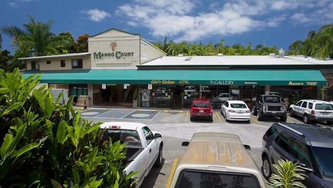
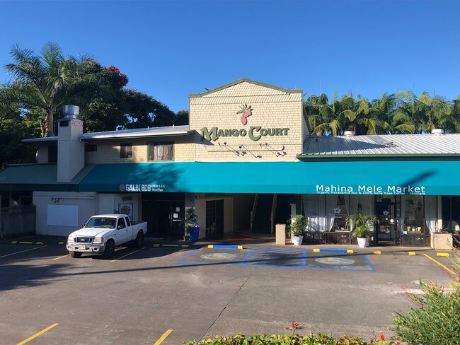
Property Record
79 Hawaii Belt Rd, Kealakekua, HI 96750

NEARBY LISTINGS FOR SALE OR LEASE
Property Detail
79 Hawaii Belt Rd
3-7-9-007-029-0000
Kainaliu Village
Commercialnec
1.897 AC DES POR RP GR 1462
X
Hawaii
1551660968F
Hawaii
2024
1.90 AC
2025
Kona/West Big Island
021402
Hawaii
17,328 SF
Hilo, HI
DEMOGRAPHICS near 79 Hawaii Belt Rd
1 Mile
3 Mile
5 Mile
2024 Total Population
3,253
6,592
12,315
2029 Population
3,388
6,844
13,193
Pop Growth 2024-2029
+ 4.15%
+ 3.82%
+ 7.13%
Average Age
44
45
46
2024 Total Households
1,105
2,267
4,440
HH Growth 2024-2029
+ 3.80%
+ 3.57%
+ 7.25%
Median Household Inc
$80,452
$78,180
$76,646
Avg Household Size
2.80
2.80
2.60
2024 Avg HH Vehicles
2.00
2.00
2.00
Median Home Value
$675,587
$694,337
$737,790
Median Year Built
1975
1976
1979
Nearby Places
- Restaurants
- Banks
- Shops
- Fitness
- Groceries
PUBLIC TRANSPORTATION
AIRPORT
Ellison Onizuka Kona International at Keahole
DRIVE
WALK
Distance
Ellison Onizuka Kona International at Keahole
31 min
17.5 mi
SALE & LEASE HISTORY
LISTING DATE
SALE/LEASE

Sep 25, 2016
For Lease
Oct 29, 2019
For Sale
Feb 21, 2018
For Sale
Dec 06, 2016
For Sale
Apr 15, 2019
For Sale
Nearby Properties
Address
Land Use
TOTAL SIZE
Lot Size
Zoning
Address
Land Use
TOTAL SIZE
Lot Size
Zoning
4,774 SF
1.15 AC
A-1a
Address
Land Use
TOTAL SIZE
Lot Size
Zoning
19,163 SF
15.56 AC
A-1a
Address
Land Use
TOTAL SIZE
Lot Size
Zoning
5,349 SF
1.73 AC
A-1a
Address
Land Use
TOTAL SIZE
Lot Size
Zoning
4,284 SF
1.42 AC
A-1a
Address
Land Use
TOTAL SIZE
Lot Size
Zoning
16,364 SF
5.84 AC
A-5a
Address
Land Use
TOTAL SIZE
Lot Size
Zoning
4,638 SF
1.25 AC
A-1a
Address
Land Use
TOTAL SIZE
Lot Size
Zoning
1,392.71 AC
A-1a
Address
Land Use
TOTAL SIZE
Lot Size
Zoning
27,840 SF
2.08 AC
CV-7.5
Address
Land Use
TOTAL SIZE
Lot Size
Zoning
5,204 SF
1.10 AC
A-1a
Address
Land Use
TOTAL SIZE
Lot Size
Zoning
4,682 SF
1.35 AC
A-1a
Address
Land Use
TOTAL SIZE
Lot Size
Zoning
30,714 SF
5.57 AC
RM-4
Address
Land Use
TOTAL SIZE
Lot Size
Zoning
157.10 AC
A-1a
Address
Land Use
TOTAL SIZE
Lot Size
Zoning
4,166 SF
1.58 AC
A-1a
Address
Land Use
TOTAL SIZE
Lot Size
Zoning
3,771 SF
1.34 AC
A-1a
Address
Land Use
TOTAL SIZE
Lot Size
Zoning
4,586 SF
1.19 AC
A-1a
Address
Land Use
TOTAL SIZE
Lot Size
Zoning
1.41 AC
A-1a
Address
Land Use
TOTAL SIZE
Lot Size
Zoning
4,774 SF
1.28 AC
A-1a
Address
Land Use
TOTAL SIZE
Lot Size
Zoning
5,035 SF
1.25 AC
A-1a
Address
Land Use
TOTAL SIZE
Lot Size
Zoning
12,465 SF
10.08 AC
A-5a
Address
Land Use
TOTAL SIZE
Lot Size
Zoning
3,386 SF
1 AC
A-1a
Address
Land Use
TOTAL SIZE
Lot Size
Zoning
2,016 SF
105.99 AC
A-5a
Address
Land Use
TOTAL SIZE
Lot Size
Zoning
2,864 SF
1.32 AC
A-1a
Address
Land Use
TOTAL SIZE
Lot Size
Zoning
5,181 SF
1.08 AC
A-1a
Address
Land Use
TOTAL SIZE
Lot Size
Zoning
5,974 SF
1.12 AC
A-1a
Address
Land Use
TOTAL SIZE
Lot Size
Zoning
3,745 SF
1.19 AC
A-1a
Address
Land Use
TOTAL SIZE
Lot Size
Zoning
3,837 SF
1.12 AC
A-1a
Address
Land Use
TOTAL SIZE
Lot Size
Zoning
42,312 SF
1.25 AC
CV-7.5
Address
Land Use
TOTAL SIZE
Lot Size
Zoning
4,632 SF
0.59 AC
A-5a
Address
Land Use
TOTAL SIZE
Lot Size
Zoning
4,587 SF
1.06 AC
A-1a
Address
Land Use
TOTAL SIZE
Lot Size
Zoning
5.06 AC
A-5a
The World's #1 Commercial Real Estate Marketplace
Connect with us
© 2025 CoStar Group
The information above has been obtained from sources believed reliable. While we do not doubt its accuracy we have not verified it and make no guarantee, warranty or representation about it. It is your responsibility to independently confirm its accuracy and completeness. Any projections, opinions, assumptions, or estimates used are for example only and do not represent the current or future performance of the property. The value of this transaction to you depends on tax and other factors which should be evaluated by your tax, financial, and legal advisors. You and your advisors should conduct a careful, independent investigation of the property to determine to your satisfaction the suitability of the property for your needs.