Property Record
79 Highway 286, Chatsworth, GA 30705
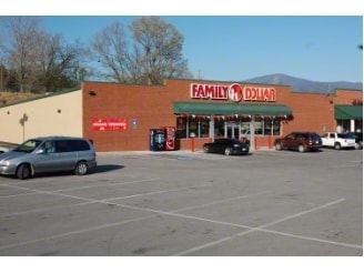
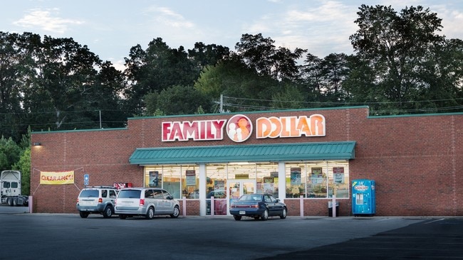

This Property Is For Sale
NEARBY LISTINGS FOR SALE OR LEASE
Property Detail
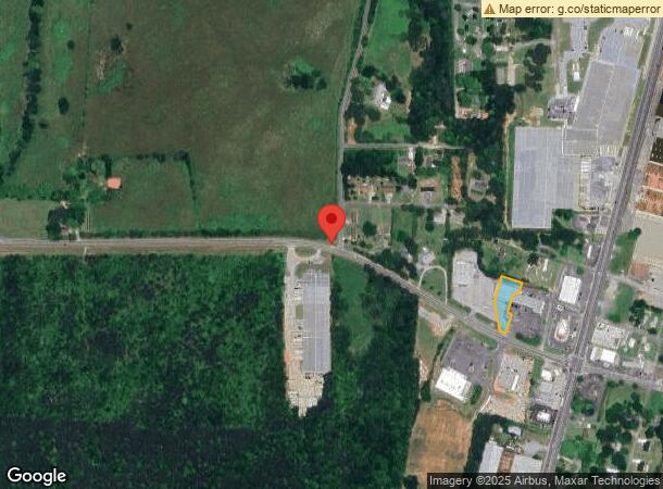
79 Highway 286
Dalton, GA
Et64a 012
0064A-019-002
LT 1 PL 44-172 ETON PLAZA
Commercialnec
Murray
X
Georgia
13213C0109D
1
2024
0.67 AC
2024
Georgia Northwest
010204
Other Market Areas
8,000 SF
DEMOGRAPHICS near 79 Highway 286
1 Mile
3 Mile
5 Mile
2024 Total Population
1,367
8,140
19,998
2029 Population
1,401
8,395
20,625
Pop Growth 2024-2029
+ 2.49%
+ 3.13%
+ 3.14%
Average Age
37
38
39
2024 Total Households
485
2,854
7,198
HH Growth 2024-2029
+ 2.47%
+ 3.05%
+ 3.07%
Median Household Inc
$64,014
$60,136
$58,529
Avg Household Size
2.80
2.80
2.70
2024 Avg HH Vehicles
3.00
2.00
2.00
Median Home Value
$133,987
$143,818
$153,549
Median Year Built
1996
1993
1992
Nearby Places
Map Layers
Map Styles
 Street
 Aerial
- Restaurants
- Banks
- Shops
- Fitness
- Groceries
PUBLIC TRANSPORTATION
AIRPORT
Lovell Field
DRIVE
WALK
Distance
Lovell Field
56 min
42.3 mi
Freight Ports
Georgia Ports - Savannah
DRIVE
WALK
Distance
Georgia Ports - Savannah
394 min
338.2 mi
Nearby Properties
Address
Land Use
TOTAL SIZE
Lot Size
Zoning
Address
Land Use
TOTAL SIZE
Lot Size
Zoning
143,078 SF
21.14 AC
SR
Address
Land Use
TOTAL SIZE
Lot Size
Zoning
96,395 SF
26.46 AC
SR
Address
Land Use
TOTAL SIZE
Lot Size
Zoning
382,147 SF
23.91 AC
IND
Address
Land Use
TOTAL SIZE
Lot Size
Zoning
773,250 SF
60.79 AC
CH
Address
Land Use
TOTAL SIZE
Lot Size
Zoning
904,772 SF
100.72 AC
CH
Address
Land Use
TOTAL SIZE
Lot Size
Zoning
57,272 SF
7.62 AC
CH
Address
Land Use
TOTAL SIZE
Lot Size
Zoning
20,884 SF
151.86 AC
AG
Address
Land Use
TOTAL SIZE
Lot Size
Zoning
552,650 SF
26.40 AC
ET
Address
Land Use
TOTAL SIZE
Lot Size
Zoning
427,972 SF
25.07 AC
ET
Address
Land Use
TOTAL SIZE
Lot Size
Zoning
95,320 SF
13.30 AC
IND
Address
Land Use
TOTAL SIZE
Lot Size
Zoning
534,454 SF
20.99 AC
ET
Address
Land Use
TOTAL SIZE
Lot Size
Zoning
1,588 AC
AG
Address
Land Use
TOTAL SIZE
Lot Size
Zoning
24,130 SF
17.92 AC
SR
Address
Land Use
TOTAL SIZE
Lot Size
Zoning
13,392 SF
7.11 AC
ET
Address
Land Use
TOTAL SIZE
Lot Size
Zoning
6,912 SF
4.54 AC
MFR
Address
Land Use
TOTAL SIZE
Lot Size
Zoning
228,850 SF
7.82 AC
IND
Address
Land Use
TOTAL SIZE
Lot Size
Zoning
175,029 SF
9.08 AC
IND
Address
Land Use
TOTAL SIZE
Lot Size
Zoning
4,800 SF
3.44 AC
MFR
Address
Land Use
TOTAL SIZE
Lot Size
Zoning
14,609 SF
2.68 AC
CH
Address
Land Use
TOTAL SIZE
Lot Size
Zoning
85,576 SF
6 AC
IND
Address
Land Use
TOTAL SIZE
Lot Size
Zoning
173,410 SF
9.56 AC
CH
Address
Land Use
TOTAL SIZE
Lot Size
Zoning
135,500 SF
30.18 AC
CH
Address
Land Use
TOTAL SIZE
Lot Size
Zoning
4,160 SF
7.10 AC
MFR
Address
Land Use
TOTAL SIZE
Lot Size
Zoning
90,200 SF
13.61 AC
IND
Address
Land Use
TOTAL SIZE
Lot Size
Zoning
31,250 SF
12.92 AC
CH
Address
Land Use
TOTAL SIZE
Lot Size
Zoning
33,674 SF
3.44 AC
CH
Address
Land Use
TOTAL SIZE
Lot Size
Zoning
161,430 SF
10.21 AC
CH
Address
Land Use
TOTAL SIZE
Lot Size
Zoning
81,600 SF
14.58 AC
ET
Address
Land Use
TOTAL SIZE
Lot Size
Zoning
100,895 SF
8.07 AC
CH
Address
Land Use
TOTAL SIZE
Lot Size
Zoning
113,246 SF
23.98 AC
ET
The World's #1 Commercial Real Estate Marketplace
Connect with us
© 2026 CoStar Group
The information above has been obtained from sources believed reliable. While we do not doubt its accuracy we have not verified it and make no guarantee, warranty or representation about it. It is your responsibility to independently confirm its accuracy and completeness. Any projections, opinions, assumptions, or estimates used are for example only and do not represent the current or future performance of the property. The value of this transaction to you depends on tax and other factors which should be evaluated by your tax, financial, and legal advisors. You and your advisors should conduct a careful, independent investigation of the property to determine to your satisfaction the suitability of the property for your needs.