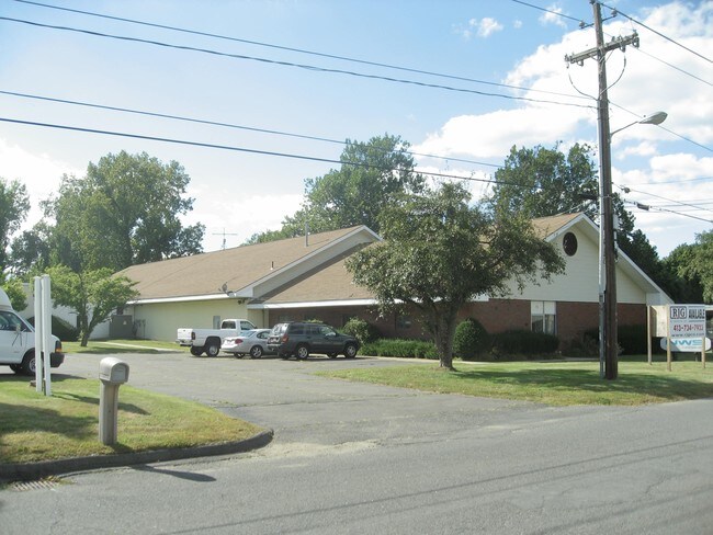
Property Record
79 Mainline Dr, Westfield, MA 01085

This Property Is For Sale
Current Lease Availabilities
Property Detail
79 Mainline Dr
WFLD-000028-R000000-000020
Hampden
Manufacturinglight
Massachusetts
AE The base floodplain where base flood elevations are provided. AE Zones are now used on new format FIRMs instead of A1-A30 Zones.
20
2025
4 AC
2025
Hampden County
812600
Hartford
19,820 SF
Springfield, MA
NEARBY LISTINGS FOR SALE OR LEASE
DEMOGRAPHICS near 79 Mainline Dr
1 mile
3 mile
5 mile
2025 Total Population
3,845
31,341
67,745
2030 Population
3,800
31,220
67,721
Pop Growth 2025-2030
(1.17%)
(0.39%)
(0.04%)
Average Age
43
42
42
2025 Total Households
1,603
12,892
26,713
HH Growth 2025-2030
(1.31%)
(0.42%)
(0.10%)
Median Household Inc
$77,278
$82,633
$88,826
Avg Household Size
2.30
2.30
2.40
2025 Avg HH Vehicles
2.00
2.00
2.00
Median Home Value
$330,803
$329,720
$339,772
Median Year Built
1957
1961
1964
Nearby Places
Map Layers
Map Styles
 Street
 Aerial
Layers
 Traffic
 Biking
Places
Listings with unknown addresses are not visible on the map
- Restaurants
- Banks
- Shops
- Fitness
- Groceries
PUBLIC TRANSPORTATION
COMMUTER RAIL
Springfield (Hartford Line - CONN DOT)
Drive
Walk
Distance
Springfield (Hartford Line - CONN DOT)
17 min
8.5 mi
AIRPORT
Bradley International
Drive
Walk
Distance
Bradley International
39 min
17.8 mi
Freight Ports
Port of New Haven
Drive
Walk
Distance
Port of New Haven
99 min
72.7 mi
Nearby Properties
Address
Land Use
TOTAL SIZE
Lot Size
Zoning
Address
Land Use
TOTAL SIZE
Lot Size
Zoning
Address
Land Use
TOTAL SIZE
Lot Size
Zoning
16.48 AC
Address
Land Use
TOTAL SIZE
Lot Size
Zoning
9.25 AC
Address
Land Use
TOTAL SIZE
Lot Size
Zoning
180,130 SF
90.75 AC
Address
Land Use
TOTAL SIZE
Lot Size
Zoning
1,992 SF
185 AC
Address
Land Use
TOTAL SIZE
Lot Size
Zoning
264,759 SF
51.70 AC
Address
Land Use
TOTAL SIZE
Lot Size
Zoning
25.35 AC
Address
Land Use
TOTAL SIZE
Lot Size
Zoning
113,406 SF
23.30 AC
Address
Land Use
TOTAL SIZE
Lot Size
Zoning
215,179 SF
9.83 AC
Address
Land Use
TOTAL SIZE
Lot Size
Zoning
14.78 AC
Address
Land Use
TOTAL SIZE
Lot Size
Zoning
64,414 SF
6.62 AC
Address
Land Use
TOTAL SIZE
Lot Size
Zoning
28.81 AC
Address
Land Use
TOTAL SIZE
Lot Size
Zoning
17,428 SF
15.80 AC
Address
Land Use
TOTAL SIZE
Lot Size
Zoning
Address
Land Use
TOTAL SIZE
Lot Size
Zoning
9.99 AC
Address
Land Use
TOTAL SIZE
Lot Size
Zoning
50,911 SF
3.31 AC
Address
Land Use
TOTAL SIZE
Lot Size
Zoning
43,050 SF
11.60 AC
Address
Land Use
TOTAL SIZE
Lot Size
Zoning
42.70 AC
Address
Land Use
TOTAL SIZE
Lot Size
Zoning
275,103 SF
23.28 AC
Address
Land Use
TOTAL SIZE
Lot Size
Zoning
9.80 AC
Address
Land Use
TOTAL SIZE
Lot Size
Zoning
6.80 AC
Address
Land Use
TOTAL SIZE
Lot Size
Zoning
100,908 SF
1.84 AC
Address
Land Use
TOTAL SIZE
Lot Size
Zoning
53,734 SF
8 AC
Address
Land Use
TOTAL SIZE
Lot Size
Zoning
97,311 SF
5.11 AC
Address
Land Use
TOTAL SIZE
Lot Size
Zoning
51,608 SF
6.43 AC
IR
Address
Land Use
TOTAL SIZE
Lot Size
Zoning
Address
Land Use
TOTAL SIZE
Lot Size
Zoning
63,175 SF
4.39 AC
IR
Address
Land Use
TOTAL SIZE
Lot Size
Zoning
53,734 SF
15 AC
Address
Land Use
TOTAL SIZE
Lot Size
Zoning
Address
Land Use
TOTAL SIZE
Lot Size
Zoning
4.44 AC
The World's #1 Commercial Real Estate Marketplace
Connect with us
© 2026 CoStar Group
The information above has been obtained from sources believed reliable. While we do not doubt its accuracy we have not verified it and make no guarantee, warranty or representation about it. It is your responsibility to independently confirm its accuracy and completeness. Any projections, opinions, assumptions, or estimates used are for example only and do not represent the current or future performance of the property. The value of this transaction to you depends on tax and other factors which should be evaluated by your tax, financial, and legal advisors. You and your advisors should conduct a careful, independent investigation of the property to determine to your satisfaction the suitability of the property for your needs.