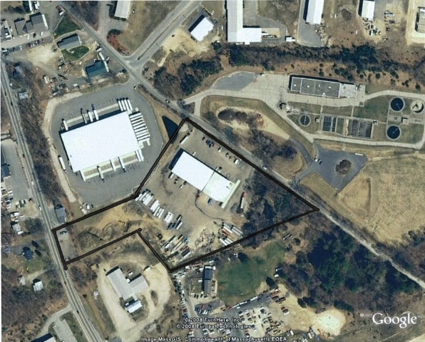
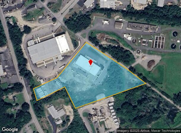
Property Record
79 River Rd, Uxbridge, MA 01569
NEARBY LISTINGS FOR SALE OR LEASE
Property Detail
79 River Rd
Warehouse
Worcester
AE
Massachusetts
25021C0300E
7.40 AC
2025
Outlying Worcester
2025
Boston
749100
Worcester, MA-CT
25,100 SF
UXBR-304045013450000T
DEMOGRAPHICS near 79 River Rd
1 Mile
3 Mile
5 Mile
2024 Total Population
522
12,094
38,908
2029 Population
531
12,136
38,785
Pop Growth 2024-2029
+ 1.72%
+ 0.35%
(0.32%)
Average Age
43
42
43
2024 Total Households
196
4,526
15,154
HH Growth 2024-2029
+ 1.53%
+ 0.31%
(0.40%)
Median Household Inc
$133,035
$114,776
$105,682
Avg Household Size
2.60
2.60
2.50
2024 Avg HH Vehicles
2.00
2.00
2.00
Median Home Value
$450,000
$416,329
$399,692
Median Year Built
1997
1983
1978
Nearby Places
Map Layers
Map Styles
 Street
 Aerial
- Restaurants
- Banks
- Shops
- Fitness
- Groceries
PUBLIC TRANSPORTATION
AIRPORT
Worcester Regional
DRIVE
WALK
Distance
Worcester Regional
37 min
24.9 mi
Rhode Island Tf Green International
DRIVE
WALK
Distance
Rhode Island Tf Green International
41 min
28.2 mi
Nearby Properties
Address
Land Use
TOTAL SIZE
Lot Size
Zoning
Address
Land Use
TOTAL SIZE
Lot Size
Zoning
450,800 SF
56.41 AC
I
Address
Land Use
TOTAL SIZE
Lot Size
Zoning
602,336 SF
204.50 AC
B
Address
Land Use
TOTAL SIZE
Lot Size
Zoning
108.65 AC
RC
Address
Land Use
TOTAL SIZE
Lot Size
Zoning
48,071 SF
44.42 AC
I
Address
Land Use
TOTAL SIZE
Lot Size
Zoning
27,720 SF
4.36 AC
I
Address
Land Use
TOTAL SIZE
Lot Size
Zoning
93,424 SF
6.90 AC
I
Address
Land Use
TOTAL SIZE
Lot Size
Zoning
65,809 SF
17.66 AC
BN
Address
Land Use
TOTAL SIZE
Lot Size
Zoning
28,468 SF
1.24 AC
I
Address
Land Use
TOTAL SIZE
Lot Size
Zoning
42,837 SF
11.32 AC
RS
Address
Land Use
TOTAL SIZE
Lot Size
Zoning
52,041 SF
47.80 AC
VRD
Address
Land Use
TOTAL SIZE
Lot Size
Zoning
45,960 SF
2.88 AC
RA
Address
Land Use
TOTAL SIZE
Lot Size
Zoning
64,110 SF
6 AC
I
Address
Land Use
TOTAL SIZE
Lot Size
Zoning
9,464 SF
53.10 AC
AG
Address
Land Use
TOTAL SIZE
Lot Size
Zoning
33,552 SF
7.87 AC
I
Address
Land Use
TOTAL SIZE
Lot Size
Zoning
53,875 SF
5.42 AC
C
Address
Land Use
TOTAL SIZE
Lot Size
Zoning
7,176 SF
4.55 AC
I
Address
Land Use
TOTAL SIZE
Lot Size
Zoning
56.47 AC
RES
Address
Land Use
TOTAL SIZE
Lot Size
Zoning
22,680 SF
29.31 AC
RC
Address
Land Use
TOTAL SIZE
Lot Size
Zoning
17,987 SF
I
Address
Land Use
TOTAL SIZE
Lot Size
Zoning
43,654 SF
5.29 AC
I
Address
Land Use
TOTAL SIZE
Lot Size
Zoning
17,924 SF
5.62 AC
I
Address
Land Use
TOTAL SIZE
Lot Size
Zoning
18,424 SF
4.93 AC
RC
Address
Land Use
TOTAL SIZE
Lot Size
Zoning
2,706 SF
43.74 AC
RC
Address
Land Use
TOTAL SIZE
Lot Size
Zoning
9,404 SF
0.77 AC
B
Address
Land Use
TOTAL SIZE
Lot Size
Zoning
16,507 SF
0.87 AC
B
Address
Land Use
TOTAL SIZE
Lot Size
Zoning
32,428 SF
5.99 AC
B
Address
Land Use
TOTAL SIZE
Lot Size
Zoning
27,673 SF
10.01 AC
B
Address
Land Use
TOTAL SIZE
Lot Size
Zoning
5,728 SF
11.73 AC
I
Address
Land Use
TOTAL SIZE
Lot Size
Zoning
21,993 SF
2.66 AC
B
The World's #1 Commercial Real Estate Marketplace
Connect with us
© 2025 CoStar Group
The information above has been obtained from sources believed reliable. While we do not doubt its accuracy we have not verified it and make no guarantee, warranty or representation about it. It is your responsibility to independently confirm its accuracy and completeness. Any projections, opinions, assumptions, or estimates used are for example only and do not represent the current or future performance of the property. The value of this transaction to you depends on tax and other factors which should be evaluated by your tax, financial, and legal advisors. You and your advisors should conduct a careful, independent investigation of the property to determine to your satisfaction the suitability of the property for your needs.