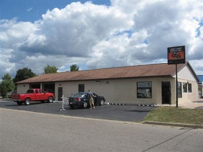
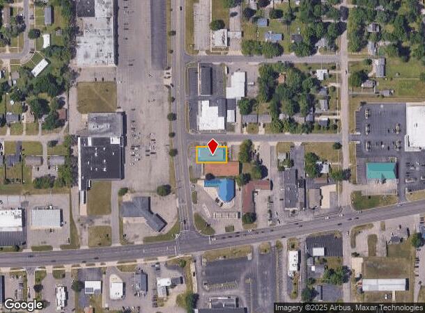
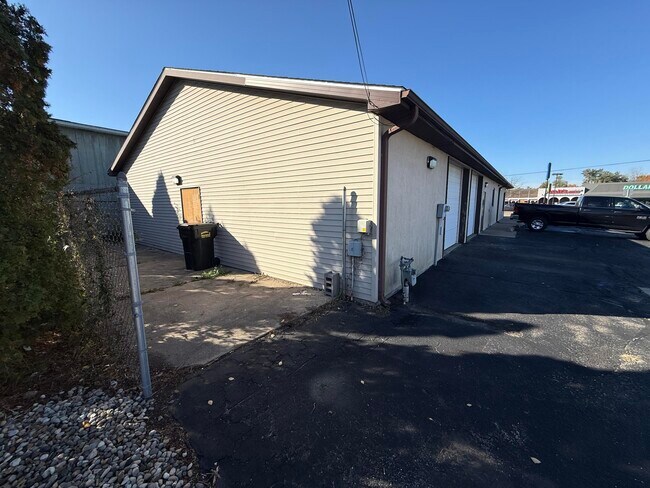
Property Record
79 20Th St S, Battle Creek, MI 49015
Current Lease Availabilities
NEARBY LISTINGS FOR SALE OR LEASE
Property Detail
79 20Th St S
Battle Creek, MI
Prairieview Gardens Subdivision
6970-13-946-0
SUPRS PLAT OF PRAIRIEVIEW GARDEN LOT 46
Storebuilding
Calhoun
X
Michigan
26025C0187C
46
0
0.19 AC
2025
Battle Crk/W Calhoun Cnty
001400
West Michigan
3,748 SF
DEMOGRAPHICS near 79 20Th St S
1 Mile
3 Mile
5 Mile
2024 Total Population
8,293
38,364
74,714
2029 Population
8,165
38,030
74,025
Pop Growth 2024-2029
(1.54%)
(0.87%)
(0.92%)
Average Age
39
39
39
2024 Total Households
3,359
15,188
30,666
HH Growth 2024-2029
(1.52%)
(0.90%)
(0.95%)
Median Household Inc
$52,119
$50,156
$48,605
Avg Household Size
2.40
2.40
2.30
2024 Avg HH Vehicles
2.00
2.00
2.00
Median Home Value
$103,719
$120,305
$116,865
Median Year Built
1951
1954
1959
Nearby Places
- Restaurants
- Banks
- Shops
- Fitness
- Groceries
PUBLIC TRANSPORTATION
COMMUTER RAIL
Battle Creek (Blue Water - Amtrak, Wolverine - Amtrak)
DRIVE
WALK
Distance
Battle Creek (Blue Water - Amtrak, Wolverine - Amtrak)
7 min
3.2 mi
AIRPORT
Kalamazoo/Battle Creek International
DRIVE
WALK
Distance
Kalamazoo/Battle Creek International
31 min
20.8 mi
Freight Ports
Port of Toledo
DRIVE
WALK
Distance
Port of Toledo
155 min
124.5 mi
Nearby Properties
Address
Land Use
TOTAL SIZE
Lot Size
Zoning
Address
Land Use
TOTAL SIZE
Lot Size
Zoning
337,297 SF
18.85 AC
T4
Address
Land Use
TOTAL SIZE
Lot Size
Zoning
291,206 SF
18.98 AC
T4
Address
Land Use
TOTAL SIZE
Lot Size
Zoning
158,242 SF
28.01 AC
B1
Address
Land Use
TOTAL SIZE
Lot Size
Zoning
174,064 SF
T4
Address
Land Use
TOTAL SIZE
Lot Size
Zoning
131,048 SF
12.28 AC
R1A
Address
Land Use
TOTAL SIZE
Lot Size
Zoning
111,002 SF
AG
Address
Land Use
TOTAL SIZE
Lot Size
Zoning
134,482 SF
17.15 AC
MFR
Address
Land Use
TOTAL SIZE
Lot Size
Zoning
158,242 SF
25.25 AC
B1
Address
Land Use
TOTAL SIZE
Lot Size
Zoning
134,355 SF
5.35 AC
MFR
Address
Land Use
TOTAL SIZE
Lot Size
Zoning
308,395 SF
24.34 AC
I2
Address
Land Use
TOTAL SIZE
Lot Size
Zoning
150,018 SF
13.12 AC
MFR
Address
Land Use
TOTAL SIZE
Lot Size
Zoning
129,598 SF
0.62 AC
T5
Address
Land Use
TOTAL SIZE
Lot Size
Zoning
34,452 SF
1.12 AC
T4
Address
Land Use
TOTAL SIZE
Lot Size
Zoning
106,703 SF
9.69 AC
MFR
Address
Land Use
TOTAL SIZE
Lot Size
Zoning
94,222 SF
I2
Address
Land Use
TOTAL SIZE
Lot Size
Zoning
49,412 SF
Address
Land Use
TOTAL SIZE
Lot Size
Zoning
188,388 SF
18.15 AC
T3
Address
Land Use
TOTAL SIZE
Lot Size
Zoning
111,744 SF
9.75 AC
RM-1
Address
Land Use
TOTAL SIZE
Lot Size
Zoning
95,666 SF
46.56 AC
I1
Address
Land Use
TOTAL SIZE
Lot Size
Zoning
123,918 SF
24.50 AC
I2
Address
Land Use
TOTAL SIZE
Lot Size
Zoning
41,310 SF
3.53 AC
B2
Address
Land Use
TOTAL SIZE
Lot Size
Zoning
53,501 SF
7.34 AC
B1
Address
Land Use
TOTAL SIZE
Lot Size
Zoning
98,360 SF
0.31 AC
T5
Address
Land Use
TOTAL SIZE
Lot Size
Zoning
50,000 SF
8.48 AC
R-2
Address
Land Use
TOTAL SIZE
Lot Size
Zoning
30,463 SF
1.43 AC
B2
Address
Land Use
TOTAL SIZE
Lot Size
Zoning
82,210 SF
0.29 AC
T5
Address
Land Use
TOTAL SIZE
Lot Size
Zoning
149,939 SF
28.09 AC
I1
Address
Land Use
TOTAL SIZE
Lot Size
Zoning
38,577 SF
4.87 AC
T3
Address
Land Use
TOTAL SIZE
Lot Size
Zoning
350,559 SF
18.76 AC
I2
Address
Land Use
TOTAL SIZE
Lot Size
Zoning
45,864 SF
7.84 AC
B1
The World's #1 Commercial Real Estate Marketplace
Connect with us
© 2025 CoStar Group
The information above has been obtained from sources believed reliable. While we do not doubt its accuracy we have not verified it and make no guarantee, warranty or representation about it. It is your responsibility to independently confirm its accuracy and completeness. Any projections, opinions, assumptions, or estimates used are for example only and do not represent the current or future performance of the property. The value of this transaction to you depends on tax and other factors which should be evaluated by your tax, financial, and legal advisors. You and your advisors should conduct a careful, independent investigation of the property to determine to your satisfaction the suitability of the property for your needs.