Property Record
79 Waterville Rd, Belfast, ME 04915


Property Detail
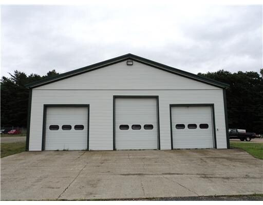
79 Waterville Rd
Commercialbuilding
Waldo
B and X Area of moderate flood hazard, usually the area between the limits of the 100-year and 500-year floods.
Maine
2025
9-a
2025
3.52 AC
043000
Other Market Areas
5,085 SF
BELF-000006-000000-000009-A000000
NEARBY LISTINGS FOR SALE OR LEASE
-
-
View all Belfast listings for sale on LoopNet.com
DEMOGRAPHICS near 79 Waterville Rd
1 mile
3 mile
5 mile
2025 Total Population
255
2,034
8,624
2030 Population
255
2,043
8,731
Pop Growth 2025-2030
0.00%
+ 0.44%
+ 1.24%
Average Age
46
46
46
2025 Total Households
113
899
3,908
HH Growth 2025-2030
0.00%
+ 0.44%
+ 1.23%
Median Household Inc
$59,499
$57,012
$62,693
Avg Household Size
2.20
2.20
2.10
2025 Avg HH Vehicles
2.00
2.00
2.00
Median Home Value
$254,999
$281,386
$303,025
Median Year Built
1990
1990
1980
Nearby Places
Map Layers
Map Styles
 Street
 Aerial
Layers
 Traffic
 Biking
Places
Listings with unknown addresses are not visible on the map
- Restaurants
- Banks
- Shops
- Fitness
- Groceries
PUBLIC TRANSPORTATION
AIRPORT
Bangor International
Drive
Walk
Distance
Bangor International
68 min
41.7 mi
Freight Ports
Searsport, ME
Drive
Walk
Distance
Searsport, ME
15 min
8.4 mi
SALE & LEASE HISTORY
LISTING DATE
SALE/LEASE

Jan 24, 2018
For Sale
Nearby Properties
Address
Land Use
TOTAL SIZE
Lot Size
Zoning
Address
Land Use
TOTAL SIZE
Lot Size
Zoning
181,936 SF
53.08 AC
Address
Land Use
TOTAL SIZE
Lot Size
Zoning
103,235 SF
24.50 AC
Address
Land Use
TOTAL SIZE
Lot Size
Zoning
70,100 SF
82.65 AC
Address
Land Use
TOTAL SIZE
Lot Size
Zoning
1.19 AC
Address
Land Use
TOTAL SIZE
Lot Size
Zoning
67,041 SF
17 AC
Address
Land Use
TOTAL SIZE
Lot Size
Zoning
4,704 SF
268.72 AC
Address
Land Use
TOTAL SIZE
Lot Size
Zoning
Address
Land Use
TOTAL SIZE
Lot Size
Zoning
65,566 SF
3.14 AC
Address
Land Use
TOTAL SIZE
Lot Size
Zoning
16,344 SF
4.22 AC
Address
Land Use
TOTAL SIZE
Lot Size
Zoning
18,880 SF
11.03 AC
Address
Land Use
TOTAL SIZE
Lot Size
Zoning
52,440 SF
17.75 AC
Address
Land Use
TOTAL SIZE
Lot Size
Zoning
44,500 SF
4.60 AC
Address
Land Use
TOTAL SIZE
Lot Size
Zoning
45,064 SF
12.11 AC
Address
Land Use
TOTAL SIZE
Lot Size
Zoning
42,059 SF
8.53 AC
Address
Land Use
TOTAL SIZE
Lot Size
Zoning
8,672 SF
38.50 AC
Address
Land Use
TOTAL SIZE
Lot Size
Zoning
9,170 SF
3.50 AC
Address
Land Use
TOTAL SIZE
Lot Size
Zoning
Address
Land Use
TOTAL SIZE
Lot Size
Zoning
14,455 SF
18.70 AC
Address
Land Use
TOTAL SIZE
Lot Size
Zoning
25,200 SF
5.57 AC
Address
Land Use
TOTAL SIZE
Lot Size
Zoning
25,964 SF
0.33 AC
Address
Land Use
TOTAL SIZE
Lot Size
Zoning
28,301 SF
3 AC
Address
Land Use
TOTAL SIZE
Lot Size
Zoning
31,486 SF
6.50 AC
Address
Land Use
TOTAL SIZE
Lot Size
Zoning
1.14 AC
Address
Land Use
TOTAL SIZE
Lot Size
Zoning
25,941 SF
6 AC
Address
Land Use
TOTAL SIZE
Lot Size
Zoning
18,738 SF
4.47 AC
Address
Land Use
TOTAL SIZE
Lot Size
Zoning
7,320 SF
2.41 AC
Address
Land Use
TOTAL SIZE
Lot Size
Zoning
16,744 SF
0.84 AC
Address
Land Use
TOTAL SIZE
Lot Size
Zoning
23,765 SF
8.30 AC
Address
Land Use
TOTAL SIZE
Lot Size
Zoning
1.51 AC
Address
Land Use
TOTAL SIZE
Lot Size
Zoning
8,223 SF
0.83 AC
The World's #1 Commercial Real Estate Marketplace
Connect with us
© 2026 CoStar Group
The information above has been obtained from sources believed reliable. While we do not doubt its accuracy we have not verified it and make no guarantee, warranty or representation about it. It is your responsibility to independently confirm its accuracy and completeness. Any projections, opinions, assumptions, or estimates used are for example only and do not represent the current or future performance of the property. The value of this transaction to you depends on tax and other factors which should be evaluated by your tax, financial, and legal advisors. You and your advisors should conduct a careful, independent investigation of the property to determine to your satisfaction the suitability of the property for your needs.