Property Record
790 E Johnstown Rd, Columbus, OH 43230
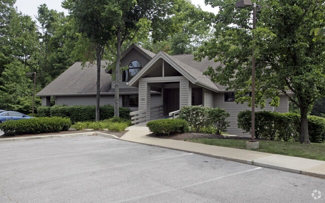
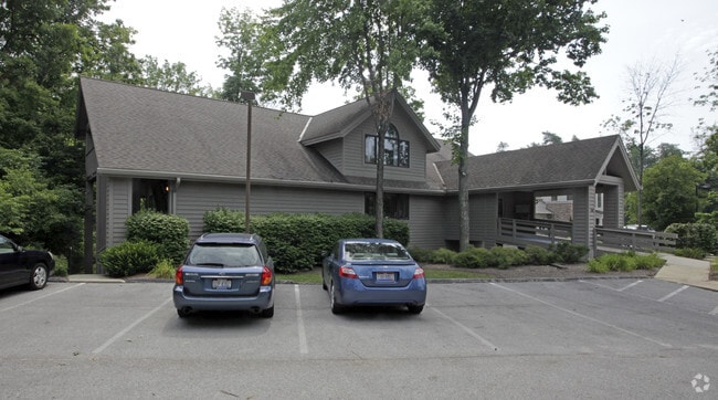

Property Detail
790 E Johnstown Rd
025-001925
JOHNSTOWN RD R16 T1 1/4T2 0.837 ACRE
Officebuilding
FRANKLIN
A Areas with a 1% annual chance of flooding and a 26% chance of flooding over the life of a 30-year mortgage.
Ohio
2024
1.49 AC
2025
East
007492
Columbus
13,860 SF
Columbus, OH
NEARBY LISTINGS FOR SALE OR LEASE
DEMOGRAPHICS near 790 E Johnstown Rd
1 mile
3 mile
5 mile
2025 Total Population
9,035
70,163
201,239
2030 Population
9,180
72,266
207,609
Pop Growth 2025-2030
+ 1.60%
+ 3.00%
+ 3.17%
Average Age
43
39
38
2025 Total Households
3,691
28,860
81,354
HH Growth 2025-2030
+ 1.68%
+ 2.96%
+ 3.29%
Median Household Inc
$115,502
$97,131
$82,295
Avg Household Size
2.40
2.40
2.40
2025 Avg HH Vehicles
2.00
2.00
2.00
Median Home Value
$374,761
$344,359
$319,462
Median Year Built
1990
1993
1992
Nearby Places
Map Layers
Map Styles
 Street
 Aerial
Transit
 Traffic
 Biking
Places
Listings with unknown addresses are not visible on the map
- Restaurants
- Banks
- Shops
- Fitness
- Groceries
PUBLIC TRANSPORTATION
AIRPORT
John Glenn Columbus International
Drive
Walk
Distance
John Glenn Columbus International
12 min
5.2 mi
Rickenbacker International
Drive
Walk
Distance
Rickenbacker International
30 min
18.6 mi
SALE & LEASE HISTORY
LISTING DATE
SALE/LEASE

Sep 25, 2016
For Lease
Nearby Properties
Address
Land Use
TOTAL SIZE
Lot Size
Zoning
Address
Land Use
TOTAL SIZE
Lot Size
Zoning
2,299,970 SF
60.76 AC
Address
Land Use
TOTAL SIZE
Lot Size
Zoning
1,935,173 SF
202.04 AC
Address
Land Use
TOTAL SIZE
Lot Size
Zoning
529,035 SF
37.56 AC
Address
Land Use
TOTAL SIZE
Lot Size
Zoning
449,494 SF
9.75 AC
Address
Land Use
TOTAL SIZE
Lot Size
Zoning
570,003 SF
29.71 AC
Address
Land Use
TOTAL SIZE
Lot Size
Zoning
186,557 SF
35.69 AC
Address
Land Use
TOTAL SIZE
Lot Size
Zoning
316,548 SF
145.20 AC
Address
Land Use
TOTAL SIZE
Lot Size
Zoning
25,298 SF
33.25 AC
Address
Land Use
TOTAL SIZE
Lot Size
Zoning
329,049 SF
38.53 AC
Address
Land Use
TOTAL SIZE
Lot Size
Zoning
242,064 SF
18.02 AC
Address
Land Use
TOTAL SIZE
Lot Size
Zoning
240,432 SF
16.59 AC
Address
Land Use
TOTAL SIZE
Lot Size
Zoning
602,448 SF
24.71 AC
Address
Land Use
TOTAL SIZE
Lot Size
Zoning
537,537 SF
77.62 AC
Address
Land Use
TOTAL SIZE
Lot Size
Zoning
47,003 SF
24.68 AC
Address
Land Use
TOTAL SIZE
Lot Size
Zoning
214,424 SF
18.57 AC
Address
Land Use
TOTAL SIZE
Lot Size
Zoning
299,890 SF
74.80 AC
Address
Land Use
TOTAL SIZE
Lot Size
Zoning
80,007 SF
27.54 AC
Address
Land Use
TOTAL SIZE
Lot Size
Zoning
331,458 SF
15.37 AC
Address
Land Use
TOTAL SIZE
Lot Size
Zoning
204,829 SF
37.69 AC
Address
Land Use
TOTAL SIZE
Lot Size
Zoning
42,596 SF
37.05 AC
Address
Land Use
TOTAL SIZE
Lot Size
Zoning
94,416 SF
0.24 AC
Address
Land Use
TOTAL SIZE
Lot Size
Zoning
71,592 SF
32.42 AC
Address
Land Use
TOTAL SIZE
Lot Size
Zoning
144,900 SF
11.04 AC
Address
Land Use
TOTAL SIZE
Lot Size
Zoning
500,376 SF
3 AC
Address
Land Use
TOTAL SIZE
Lot Size
Zoning
202,956 SF
13.40 AC
Address
Land Use
TOTAL SIZE
Lot Size
Zoning
253,893 SF
12.57 AC
Address
Land Use
TOTAL SIZE
Lot Size
Zoning
171,366 SF
28.27 AC
Address
Land Use
TOTAL SIZE
Lot Size
Zoning
150,718 SF
4.35 AC
Address
Land Use
TOTAL SIZE
Lot Size
Zoning
122,390 SF
7.77 AC
Address
Land Use
TOTAL SIZE
Lot Size
Zoning
181,819 SF
7.18 AC
The World's #1 Commercial Real Estate Marketplace
Connect with us
© 2026 CoStar Group
The information above has been obtained from sources believed reliable. While we do not doubt its accuracy we have not verified it and make no guarantee, warranty or representation about it. It is your responsibility to independently confirm its accuracy and completeness. Any projections, opinions, assumptions, or estimates used are for example only and do not represent the current or future performance of the property. The value of this transaction to you depends on tax and other factors which should be evaluated by your tax, financial, and legal advisors. You and your advisors should conduct a careful, independent investigation of the property to determine to your satisfaction the suitability of the property for your needs.